![]()
|
|
|
|
|
|
|
|
|
|
|
Proposed new town for Hartley, 1944
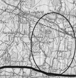
Map
showing very approximate location of 1944 proposed new town and motorway.
Hartley has developed slowly and piecemeal since the war, but it might not have been like that. For Hartley, Longfield and Meopham were designated as one of the proposed post-war new towns.
In 1942 the Standing Conference on London Regional Planning was commissioned to come up with proposals for the region outside the old county of London. The team led by Professor Patrick Abercrombie reported in 1944. Their aim was to encourage 1 million people to move from the crowded areas of inner London to new towns near London, and to discourage migration to the region by putting an embargo on new industries in the south-east. Professor Crombie said "courage is needed to seize the moment when it arrives and to make a resolute start". Professor Abercrombie said "courage is needed to seize the moment when it arrives and to make a resolute start".
Sir (Leslie) Patrick Abercrombie (1879 - 1957) was by far the greatest architect and town planner of his day. As well as London, he produced post war plans for Plymouth, Hull, Edinburgh and West Midlands amongst others. He was a modernist and clearly loved the job of proposing brand new sites, but he greatly valued the past too, in particular he was at pains to protect the beauty of the Darenth Valley. He was one of the founders of the Council for the Protection of Rural England and campaigned for the Green Belt around London before the war.
|
"The choosing of sites for new communities is always
an exhilarating side of the planner's work; it is impossible
to escape from the sequel that opportunity is to be offered
for the creation of a town which will embody the latest
ideas of civic design" |
The report proposed 10 new towns around London. They had intended that any eight of them should be built, but in the end only Stevenage, Harlow and Hemel Hempstead got off the drawing board. They did reject one site at that little place called Milton Keynes! North-west Kent proved difficult to find sites for, but the Meopham area came to the fore from about July 1943.
|
"Adams has in mind 20,000 satellite town in Meopham
area, but no site found by him as yet" (7.7.1943) |
The other sites in Kent which they rejected were:
This town of 40,000 would have included a big swathe of Hartley east of the Ash Road/Church Road junction and Castle Hill, stretching south of the railway to Hook Green just short of Meopham Green in the east. North of the railway would have been an industrial area comprising the southern half of New Barn and Longfield Hill (jam and fruit, mineral waters, plastics, agricultural implements were suggested). Just over 2 miles in diameter, the town was over 2,600 acres in extent. What remained of Hartley would be the new green belt. The town would have also been partly a dormitory suburb of Gravesend.
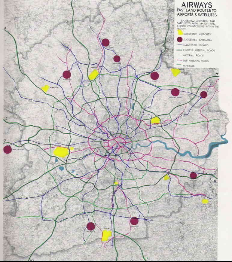
Plan showing the proposed new towns, roads and airports (click
on image to enlarge)
The town would have been divided into 4 neighbourhoods of about 500 acres, where the overall density would be about 20 people per acre, a little higher than the approximate 15 per acre today. They were greatly influenced by the garden cities of Letchworth and Welwyn, and so wanted spacious towns of small terraces of houses with generous gardens. No more than 25% of housing would be flats. They did acknowledge the undulating topography would call for some ingenuity in planning! In each 500 acres, two-thirds would be devoted to housing for 10,000 people. Of the rest 100 acres was to be open space and the rest roads, parking, shops, schools, churches and other community buildings. A town this size would qualify for 4 secondary modern schools. There would be provision for 8 churches (based on 10% of the population attending weekly) and 6 swimming pools, as well as numerous sports pitches, some to be shared with schools.
To give some idea of how the new towns would look like they gave three examples. The nearest in style to Hartley would have been Ongar in Essex, although this was scheduled to be larger (60,000 population). The town would be divided into 6 neighbourhoods of 10,000 each with their own shops, civic centre and schools. In the centre of the town would be the main shopping centre and grammar schools. The neighbourhoods would be divided by parkland and each neighbourhood itself was to be divided into smaller units by smaller green wedges. Housing would be a mixture of houses and flats at an average of 30 per acre for the built up area, and no higher than 50 per acre anywhere. Like Hartley the industry was to be in the north-east to carry any smoke or smell away from the town. One of the planners' principal aims was to "create real communities in which people can be proud to live".
1.  2.
2.  3.
3. 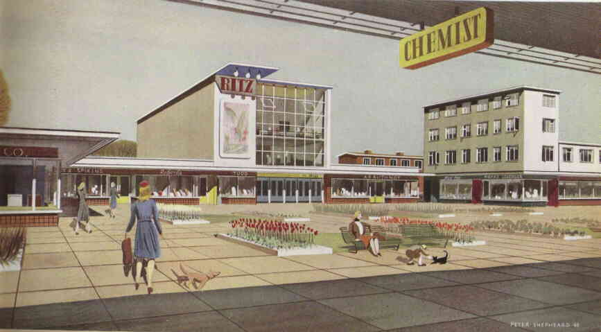
Plans
and elevations for proposed new town at Ongar (click on image to enlarge).
But what about infrastructure? Well the planners did consider this too. Thousands of houses would generate a lot of traffic, so the answer was to build a motorway from Swanley to Canterbury that would have skirted the south of Hartley just before the Ash Road/Church Road junction in New Ash Green (incidently they were first to propose the M25). The noise might not have been so much of a problem when you consider they also wanted a freight airport at Lullingstone!
A town this size would need almost 1.5 million gallons of water per day. They reckoned the Hartley pumping station, which had gone on line in 1944, might cope but another pumping station at Fawkham might become necessary (the Hartley station could pump 2¼ million gallons per day but about half went to Gravesend). On sewerage they dropped the initial plan to pump treated sewage into the chalk, preferring instead to suggest sewers to the Northfleet disposal works. They were quite worried about contamination of water supplies, saying only concrete and asphalt roads should be allowed.
Almost as soon as Professor Abercrombie had made his recommendation, than the various government departments were squabbling about the best site. The Ministry of Town Planning wanted to move the site a mile to the east so it would mainly be in Meopham with a satellite town of 10,000 planned for Longfield and Hartley. There are plans in the National Archives of how this would have looked. It is remarkable how little opposition these plans appear to have generated (there is one objection on file from the Meopham Ratepayers Committee, but none from Hartley). Perhaps there was a consensus to "win the peace".
The Ministry of Town Planning were vigorously opposed by the Ministry of Agriculture, who argued that the existing development at Hartley had harmed the agriculture of the area, and therefore there was less to lose than at Meopham. A big conference of 7 government departments was held on 20 March 1946 to try to decide between Hartley-Longfield, Meopham and a third site at Crowhurst near Croydon. This showed them to be hopelessly split. - the Departments of Town Planning, Trade, Labour, and Health backed Meopham; while Agriculture and Fuel and Power were the ministries to support Hartley-Longfield (Crowhurst got the vote of the Ministry of Transport). Wherever they went it is likely that they would have compulsorily purchased and demolished most of the existing housing.
Although the town was not built, the idea of development in Hartley didn't go away. In 1952 there were plans for an overspill town for 25,000 in Hartley-Longfield on 1,000 acres of land, a 1955 memo from the Ministry of Agriculture said that their Minister had "relunctantly" agreed to this tentative proposal, but it had fallen through because of local authority opposition. It certainly accelerated the development of Hartley, as developers bought large swathes of land in the parish in the 1950s. And who knows - did all these plans influence the decision a decade later to grant permission to New Ash Green?