| 
|
This document is the sale of land
in Hartley and Fawkham that belonged to the Walter family.
The Walters had purchased this
land in 1571, and they lived at Pennis House, but by
1657 the estate was heavily indebted and Bennett Walter,
the widow of John Walter, was forced to sell under the
terms of his will.
The purchaser was Thomas Young
of Southfleet. The family had lived there for
many years, but in 1663 they made a rebuilt Fairby their
home. It is clear from the list of adjoining landowners
in this deed that he had already bought the central
Fairby holding by 1657. The purchase from Bennett
Walter was added to this to create the Fairby farm that
existed up to the early 20th century.
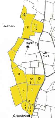
The map shows the approximate
location of the fields listed in the 1657 deed. It
is not possible to be sure in every case, as the boundaries
of the fields had clearly changed in the two centuries
before the tithe map of 1844, which this plan is based
upon. The numbers relate to the list of fields
in the 1657 deed, the land conveyed is tinted yellow.
|
Conveyance 17 August 1657
Made between
(1) Bennett Walter of Fawkham, widow
(2) Thomas Young of Southfleet
Sale of estate under the will of John Walter for £665,
of land in Ash and Hartley
1. Chapel Wood Field (4a):
bounded by Chapelwood (S); Ash to Dartford highway (E); lands of
said John Walter (W); Lower Chapel Wood Field (N)
2. Lower
Chapel Wood Field (3a): bounded by Upper Chapel Wood Field (S);
Ash to Dartford highway (E); Limekillcroft and Spring (N); lands
of John Walter (W)
3. Lymekillcroft
(3a): bounded by Chapel Field (S); Highway (E); Limekillspring (W);
Neither Field (N)
4. Lymekill
Spring (3a): bounded by lands of John Walter and lower end of Chaple
Field (S); Lymekillcroft (E); Neither Field and The Valley (N)
5. Sprimpling
Spring (2a): bounded by the highway (E & W); Neither Field (S);
Rye Croft (N).
Occupied by John Dawlton or his assignees.
6. Neither Field (10a): bounded
by the highway (W); Killcroft & Spring (S); Rye Croft (N)
7. The
Other Neither Field (7a): bounded by Neither Field (E); Lymekillspring
(S); The Valley (W)
8. Neitherfield
Hill (8a): bounded by Neither Field (S); lands of John Walter (W);
Pennis Valley Wood (N)
9. The
Valley (7a): bounded by Neither Field (E); Lymekillspring (S); Northlands
Wood (W); lands of John Walter (N)
In Hartley and Fawkham, occupied by Edward Best or his assigns.
10. Rye Croft (12a): bounded by
highway (E); Shrimplings Spring (S); Neitherfield Hill (W); lands
of said Thomas Young (N)
11. Chalkefield
(9a): bounded by lands of Thomas Edwards and Thomas Young (E); Pinnace
Valley Wood and Spring (S & W); Platfield Spring (N)
12. Grubb
Piece (3a): bounded by Platfield Spring (E); Pinnace Valley Wood
and Chalken Field (S); highway from Fawkham to Hartley (N)
In Hartley in the tenure of Widow Crowhurst
13. Great Old Downe (20a): bounded
by Fawkham to Hartley road (S); land from Fawkham to Greensted Greene
(W); Old Downes (N)
14. The Downs
(12a): bounded by the said Fawkham to Hartley road (S); Parsonage
Croft belonging to Longfield (N)
15. Little
Old Downs (4a): bounded by Upper Old Downs Wood (E); Hartley Laine
(S)
16. Hartelee Hold (4a): bounded
by Gleabeland Wood (N); Upper Old Downs Wood (E); Lower Old Downs
Wood (S)
17. Great Old Downe Wood
(10a): bounded by Hartley to Fawkham road (S); Old Downs Wood (W);
Gleabeland Wood (N)
18. Westlands
(7a): bounded by Ash to Dartford road (E); Great Old Downs Wood
(W); Morrice Croft (S); Gleabelands of Hartley (N)
19. Westlands
Spring (1a): bounded by the foresaid field (N); Hartley Laine (E)
In Fawkham and Hartley, in the occupation of Leonard Carrier.
|