| Geology and Scenery of Hartley updated 6.12.09 |
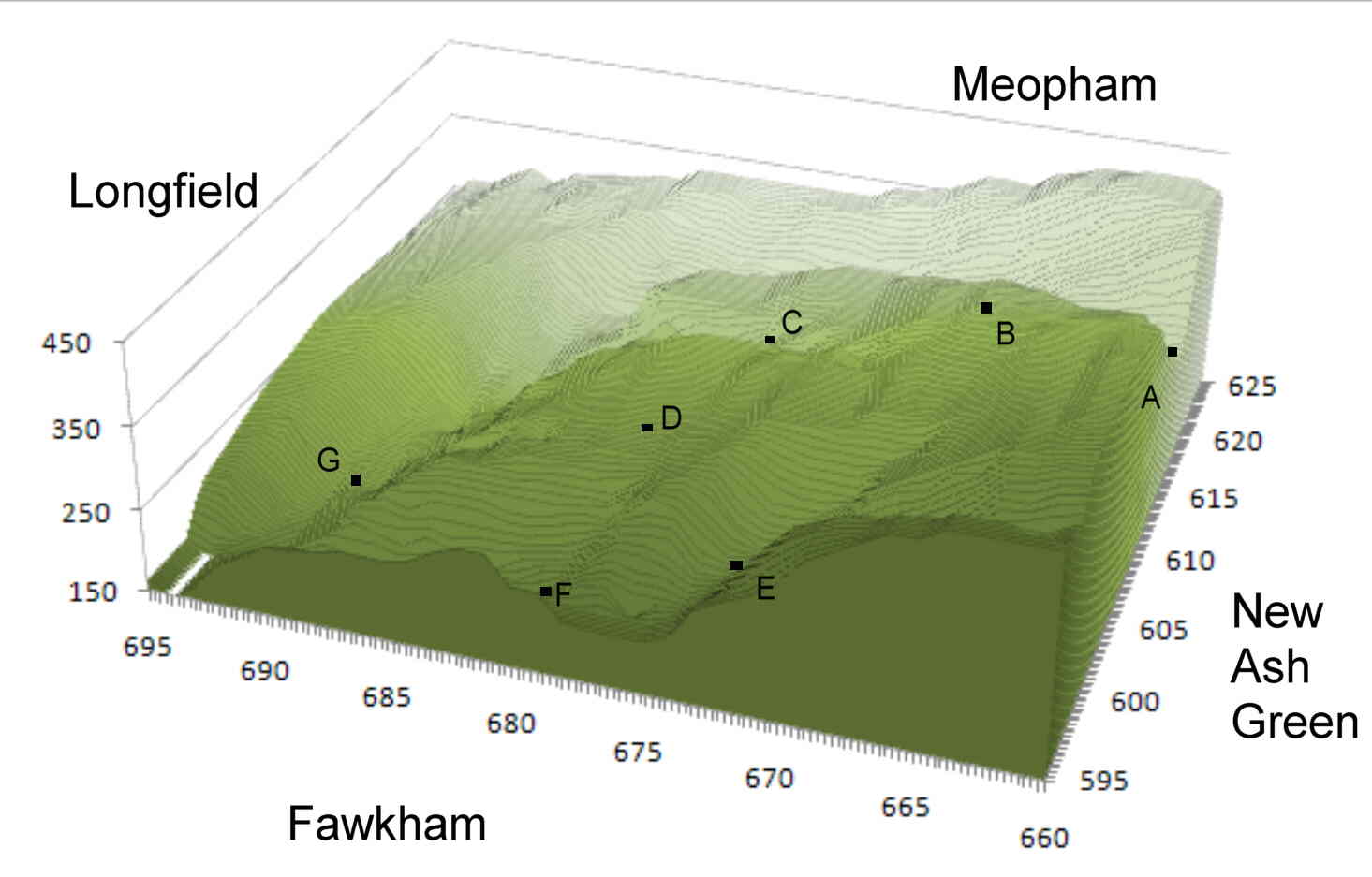
Relief Map of Hartley, Longfield and surrounding area. Heights are
in feet above sea level, the axes are the OS grid references.
(Key: A - Hartley
Bottom Farm; B - All Saints' Church; C - Springcroft; D - Hartley
Green; E - Pennis House; F - Fawkham Church; G - Longfield Church).
Description of Hartley's Geology (Quarterly Journal of the Geological Society 1851)
Special emphasis is placed on the cutting into the bank at the bottom of Hoselands Hill to build Hartley Old Rectory in c1850.
In the present communication I propose to show, that the soils which cover the chalk of Kent at various heights are analogous to the erratic warp of Norfolk ; that they are the result of aqueous transport; and not, according to the prevalent assumption, produced by atmospheric erosion which during the lapse of ages dissolved and removed the calcareous matter of the chalk, leaving behind, as upon a filter, its fine siliceous and argillaceous particles and its flints.
The district to which these remarks apply, comprises only a few square miles lying a little to the S. of Dartford ; but, if of limited extent, it is a fair type of the Kentish Chalk district in general. The rapid changes of soil in this district, where ferruginous and non-calcareous clay, clay-loam, and loam more or less sandy, as well as white calcareous soils, may be seen in the space of forty or fifty acres, would be a strong presumption against the hypothesis of formation, in situ, by chemical solution, unless it can be shown that the composition of the subjacent chalk varies with the variations of soil, and unless a satisfactory explanation can be offered of the solution of the calcareous matter in one case, and its non-solution in another. I shall furnish, however, positive evidence of aqueous transport, in alternation of deposit.
The village of Hartley stands on an elevated table-land of chalk, covered, to depths varying between one and four feet, by a soil of non- calcareous clay-loam passing into a sandy loam, and changing from one to the other within very short distances. The surface is thickly strewn with large unabraded flints and some rounded flint pebbles, referable to the eocene tertiaries, of which there are some outliers a little to the northward, as for instance at the village of Darenth. The surface of the chalk, at its junction with the soil, has been worn into pipes and cavities, some of which are four or five feet deep. Some of tbe road-cuttings show light yellow sandy loam, mixed with angular flints and eocene pebbles, resting immediately on the chalk. A little north of Firby Farm, marked on the Ordnance Map, a gradual slope commences to a valley opening into that of the Thames. The road from Darenth to Longfield and Cobham runs through the bottom of the valley. About three furlongs west of Longfield, by the side of the lane leading to Hartley, which ascends the western side of the valley, a cutting at the new Parsonage House of Hartley, now building in a wood marked on the Ordnance Map, has laid open an instructive section of the soil and subsoil above the chalk, the most material portion of which is exhibited in the accompanying section. Where the section approaches the summit and the surface of the chalk rises, the soil consists of loam and clay-loam varying from one and a half to four or five feet with the irregular surface of the chalk. In immediate contact with the chalk is a layer of dark, ferruginous, and tenacious clay, from a few inches to two feet thick, which also fills cavities in the chalk, and passes upwards into clay-loam. In some parts there are collections of reconstructed chalk, containing seams and patches of the same kind of ferruginous clay as that interposed between the surface-soil and the clay which rests.upon the chalk ; and in one of the pipes are alternations of clay with calcareous matter. Large unabraded flints and rounded flint pebbles of the eocene series are dispersed through all these deposits, and in one part shown in the section, there are accumulations of the small rounded pebbles of the eocene strata.
As the surface of the chalk sinks towards the valley, and the superficial deposits deepen, they become more blended. In the lane between the corner of the wood in which Hartley Parsonage is huilding and the Church of Longfield, a depth of five or six feet of yellow sandy loam is visible above the chalk ; and it constitutes the surface of a field on the western slope of the valley, between the wood and the Longfield and Darenth road. The eastern side of the valley rises more abruptly ; and on that side soils consisting of a white surface of chalk, aud of brown non-calcareous and whitish calcareous loams, may all be seen within an area of fifty acres. A bed of the last, several feet deep, adjoins the road, a few furlongs north of Longfield. For about a mile northward, between that point and Greenstreet Green, the road passes over a bed of coarse flints, slightly waterworn, though more so than those spread over the surface of the higher grounds. This bed of flints, which is in some parts six or seven feet deep, rests on chalk, and is perhaps about ten chains wide. The eastern side of the valley above it shows some slight indications of terraces, but they are very irregular. I have not traced these deposits northward of Greenstreet Green ; but we know that the southern bank of the Thames, in this neighbourhood, is fringed, like the northern, with mammalian and freshwater deposits, at considerable elevations above the existing stream, but lower than the non-fossiliferous deposits described above.