Merton Avenue, Fortuna Close, Merryfields Close
By Peter J Mayer, 19.9.2017
About the road
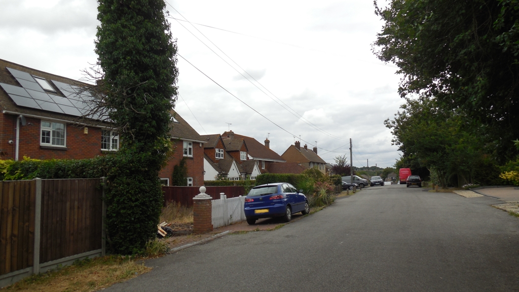
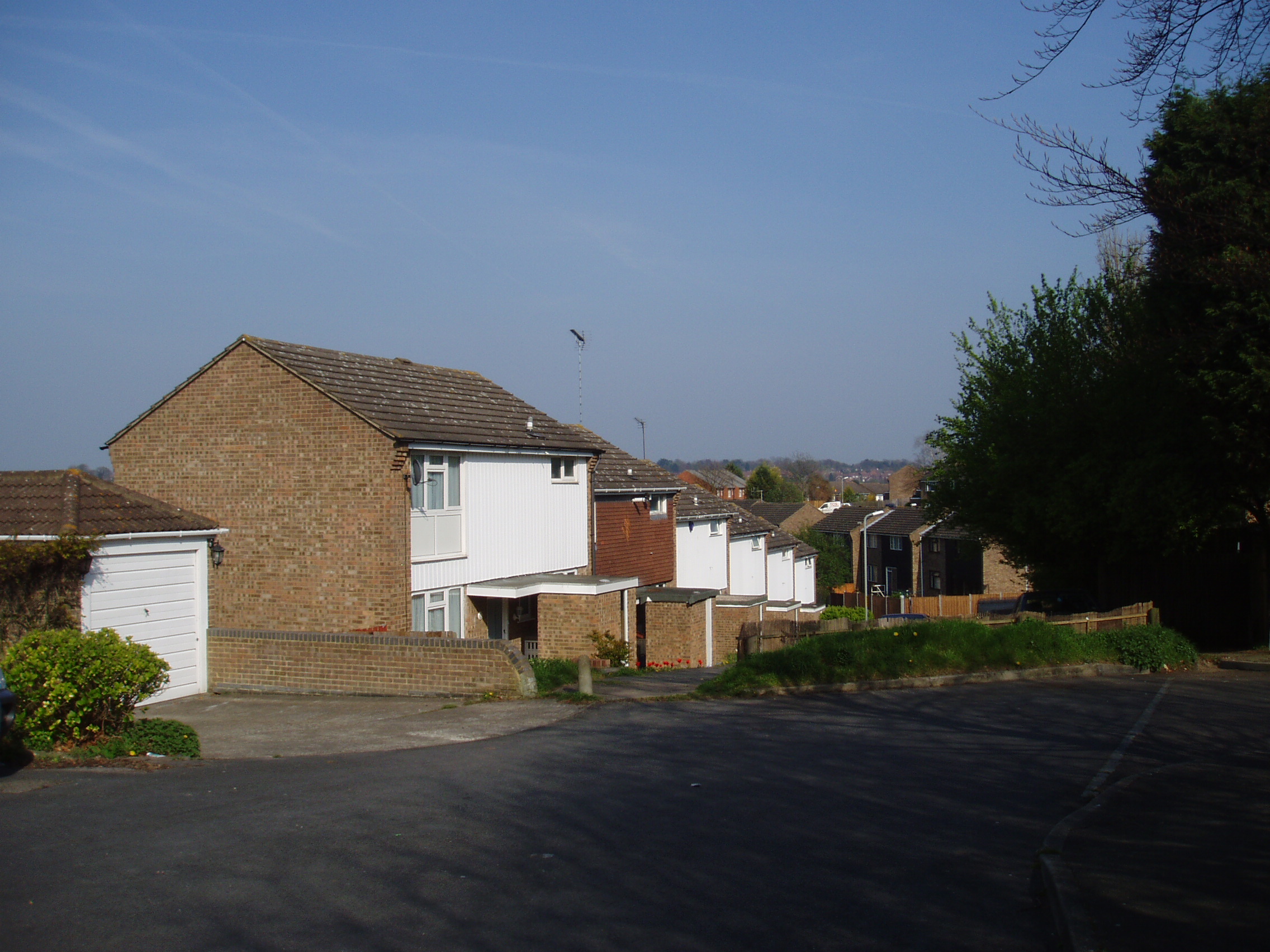
Merton Avenue - north side showing numbers 1-13 (odd)
Merton Avenue is a road in two parts in the north part of Hartley. The major part is off Ash Road (Hoselands Hill), but 6 houses are accessed from Hawthorns. It has a mixture of houses and bungalows of differing dates and styles.
The roadd was created in about 1905, following the acquisition of the land by a firm of London estate agents called Payne Trapps & Co. No-one is really sure where the name came from. Originally the road was much longer as it ran across what is now the Wellfield Estate to Woodland Avenue. Very few houses were built after the plots were sold and most of the land became derilict, in 1939 only three houses existed here - Nil Desperandum (1921, rebuilt 1934, Crawden Bank (1927), Somerleyton (1932-2005), and View Point (1935-1984). In both wars the other land was requisitioned to be ploughed up for food production.
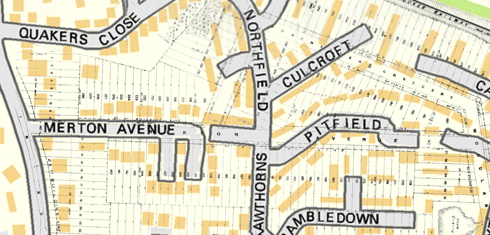
Merton Avenue - Payne and Trapps Map of 1908 overlaid on modern map
Contains OS data © Crown copyright (2016)
The first recorded inhabitant was Mr W E Barlow (1869-1952) and his family in 1921. They had been made homeless from their house in south-east London, but were the owners of a plot of land here. The council found he, his wife and 4 children aged 4 months to 7 years were living in a single tent. Mr Barlow had erected a rough earth closet for sewage and was getting water from nearby premises. Faced with council orders to evict him, Mr Barlow started building a chalk and flint house himself in 1922. The council said (1924) it was totally unfit for human habitation, as 2 adults and 5 children had only 2 rooms between them and they had to go 200 yards to get water. However Mr Barlow clung on. He was still there in 1928 when the council got a court order for him to leave his house. Mr Barlow ostensibly moved into a caravan next to the house but the council was convinced he was really still living in the house. Finally he completed a house the council approved of in 1934. Not for nothing did he call it 'Nil Desperandum' (='Don't despair')!
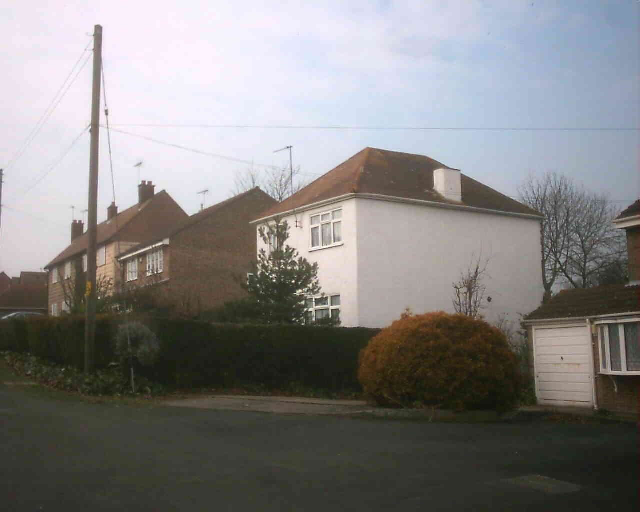
Merton Avenue - Nil Desperandum, taken 14.4.2007, before 2014 extension
After the war Merton Avenue was nominated by the parish council as a site for Hartley's first council houses and Dartford Rural District Council compulsorily purchased the land in 1947. They built six semi-detached pre-fabricated Airey Houses in about 1948 - 1&3, 7&9 and 11&13. Numbers 11 and 13 still have their original look but 7 and 9 were demolished and replaced in 2001. I think 1 and 3 may have been refaced.
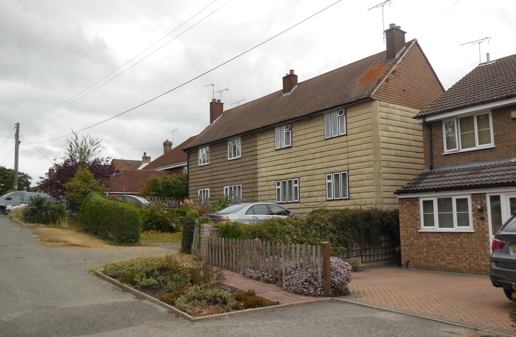
Merton Avenue - Airey Houses (11 & 13)
Merton Avenue is now divided in two by an earth bund. This came about because of the development of the Wellfield Estate, which meant extra traffic along Merton Avenue. As an unadopted road this meant that the extra costs of maintenance fell upon the people who lived there. During 1970s there were plans for either Kent County Council or Sevenoaks Council to pay for it to be made up and adopted. The residents association objected to the £27,000 price tag that KCC were threatening to charge them . However according to newspaper reports, as soon as KCC realised that Sevenoaks would be the main beneficary, they said the council should pay, Sevenoaks didn't want to so the plans fell through in 1978 (Gravesend Reporter & Dartford Chronicle, both 2.9.1977). The following year Sevenoaks Council said they had no plans to stop through traffic. Shortly after the residents took matters into their own hands by building an earth bund across the road, apparently Sevenoaks council removed it only for the residents to put it back again with a mechanical digger. And that's the situation today; presumably the council discovered that there was little they could do legally, as the road was never a public right of way.
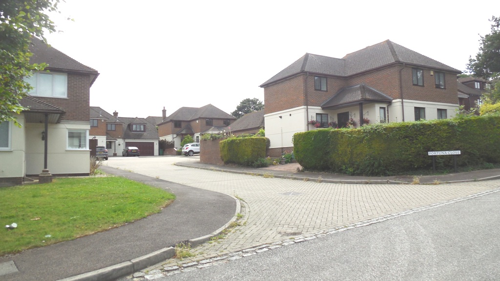
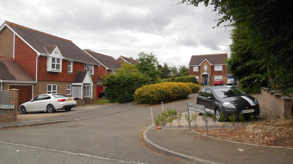
On the south side are two cul-de-sac roads. Fortuna Close was built on the former house of that name. While adjoining it, Wild Barfield made way for Merryfields Close in 1995.
Merton Avenue - Bund and numbers 25-35
Statistics about the road
| Subject | Details |
|---|---|
| Length of Road: | Merton Avenue 0.12 miles (199m) Fortuna Close 0.03 miles (47m) Merryfields Close 0.03 miles (47m) |
| KCC Reference: | Merton Avenue P6198 (Private Street, 175m) Merton Avenue U23366 (adopted, 24m) Fortuna Close P14139 (Private Street) Merryfields Close P14216 (Private Street) |
| Acreage: | Merton Avenue 2.69 acres / 1.09 ha Fortuna Close 0.59 acres / 0.24 ha Merryfields Close 0.67 acres / 0.27 ha |
|
Houses/Flats |
Merton Avenue 24 Fortuna Close 5 Merryfields Close 5 |
| Density: | Merton Avenue 8.9 houses/acre (22.0 houses/ha) Fortuna Close 8.4 houses/acre (20.8 houses/ha) Merryfields Close 7.5 houses/acre (18.5 houses/ha) (Hartley average 4.9 houses/acre) |
| Population (2011): | Merton Avenue 61 Fortuna Close 17 Merryfields Close 14 |
| Companies with registered address here (2013): | Merton Avenue 2 Fortuna Close 1 Merryfields Close 0 |
Information about the houses
Explanation:
Date of Construction is sometimes approximate.
Plot histories include the ancient farms and fields, as well as the plot numbers
on the Payne and Trapps estate.
(1) Planning Permissions include the reference number, so more details can be seen at Sevenoaks Council.
My records are not complete and do not include refused or withdrawn applications.
(2) Before Council Tax the tax on residential property was called the rates. The registers for 1956, 1963 and 1972 are
held at Sevenoaks Council. The rateable value given is the gross estimated rental value of the property, that is how much
the Valuation Office thought people would pay to rent it, the rates were actually calculated on a lower value after certain
statutory allowances were made. For some reason the 1956 register contains the rateable value for the properties as it would
have been in 1939.
(3) Council tax is based on what the Valuation Office thought the property would have sold for in 1993. It is divided into 8 value bands.
(4) House price data 1995 to date produced by Land Registry © Crown copyright 2016. To report
an error, go to Change a sales record form.
I have tried to make sure the information is accurate, but no responsibility can be taken for any errors. If you plan to rely on the information, you should check the source data to be sure. If you spot an error, please let me know via the contact form.
Crawden Bank Merton Avenue, DA3 7EB
Built: 1927
(1) Plot History: Blue House Farm - Care Hill (1844)
(1) Plot History: Plots 9-10 Fawkham Park Estate (1908)
(2) Planning Permission: 1985/390 Extension
(2) Planning Permission: 1987/1141 Extension, garage and access
(3) Rateable Value (1956): £39
(3) Rateable Value (1963): £118
(4) Council Tax (1993): Band E (£88-120K)
(5) Sale (1 Jul 1972): £6,500
1 Merton Avenue, DA3 7EB
Built: 1949
(1) Plot History: Blue House Farm - Yew Tree Field (1844)
(1) Plot History: Plots 229-230 Fawkham Park Estate (1908)
(2) Plot History: 2007/3254 Single storey rear extension and attached garage (2007)
(4) Council Tax (2007): Band 2007/2330 Rear extension and attached garage
(3) Rateable Value (1956): £37
(3) Rateable Value (1963): £105
(3) Rateable Value (1972): £239
(4) Council Tax (1993): Band D (£68-88K)
(5) Sale (29 Aug 1996): £77,000
(5) Sale (21 May 2014): £390,000
3 Merton Avenue, DA3 7EB
Built: 1949
(1) Additional or Former House Name: Pavalay 2000 Limited (Business) (2015)
(1) Size: 4 bed (2009)
(1) Plot History: Blue House Farm - Yew Tree Field (1844)
(1) Plot History: Plots 228-229 Fawkham Park Estate (1908)
(2) Planning Permission: 2005/1225 Demolish existing extension and replace with new
(2) Planning Permission: 2007/2145 Loft conversion with rear dormer
(2) Planning Permission: 2013/758 The erection of a conservatory to the rear of the property.
(3) Rateable Value (1956): £37
(3) Rateable Value (1963): £105
(3) Rateable Value (1972): £259
(4) Council Tax (1993): Band D (£ExK)
(4) Council Tax (2009): Band E (£88-120K)
(5) Sale (16 Jan 1998): £89,995
(5) Sale (20 Aug 2001): £160,500
(5) Sale (18 Mar 2005): £247,000
(5) Sale (2 Mar 2009): £330,000
5 Merton Avenue, DA3 7EB
Built: 1949
(1) Additional or Former House Name: Glenview (2015)
(1) Plot History: Blue House Farm - Yew Tree Field (1844)
(1) Plot History: Plots 226-227 Fawkham Park Estate (1908)
(3) Rateable Value (1956): £47
(3) Rateable Value (1963): £130
(3) Rateable Value (1972): £282
(4) Council Tax (1993): Band E (£88-120K)
(5) Sale (30 Apr 1996): £104,000
7 Merton Avenue, DA3 7EB
Built: 1949
Demolished: 2001
Rebuilt: 2002
(1) Plot History: Blue House Farm - Yew Tree Field (1844)
(1) Plot History: Plot 225 Fawkham Park Estate (1908)
(2) Planning Permission: 2000/1782 Demolish Airey Houses and replace with 2 semis
(2) Planning Permission: 2001/1003 Details (materials, slab levels) to 00/1782
(3) Rateable Value (1956): £37
(3) Rateable Value (1963): £105
(3) Rateable Value (1972): £239
(4) Council Tax (1993): Band F (£ExK)
(4) Council Tax (2002): Band F (£120-160K)
(4) Council Tax (2002): Band G (£ExK)
(5) Sale (3 May 2000): £85,000
(5) Sale (27 Jun 2002): £265,000
9 Merton Avenue, DA3 7EB
Built: 1949
Demolished: 2001
Rebuilt: 2001
(1) Size: 4 bed (2009)
(1) Plot History: Blue House Farm - Yew Tree Field (1844)
(1) Plot History: Plots 223-224 Fawkham Park Estate (1908)
(2) Planning Permission: 2000/1782 Demolish Airey Houses and replace with 2 semis
(2) Planning Permission: 2001/1003 Details (materials, slab levels) to 00/1782
(2) Planning Permission: 2004/2794 Rear conservatory
(3) Rateable Value (1956): £37
(3) Rateable Value (1963): £105
(3) Rateable Value (1972): £239
(4) Council Tax (1993): Band F (£120-160K)
(4) Council Tax (2001): Band F (£120-160K)
(5) Sale (2 Sep 1985): £19,500
(5) Sale (10 Dec 1996): £45,000
(5) Sale (2 Aug 2000): £90,000
(5) Sale (21 Aug 2002): £270,000
(5) Sale (13 Nov 2009): £378,000
11 Merton Avenue, DA3 7EB
Built: 1949
(1) Plot History: Blue House Farm - Yew Tree Field (1844)
(1) Plot History: Plots 222-223 Fawkham Park Estate (1908)
(3) Rateable Value (1956): £37
(3) Rateable Value (1963): £105
(3) Rateable Value (1972): £239
(4) Council Tax (1993): Band C (£52-68K)
13 Merton Avenue, DA3 7EB
Built: 1949
(1) Plot History: Blue House Farm - Care Hill (1844)
(1) Plot History: Plot 221 Fawkham Park Estate (1908)
(3) Rateable Value (1956): £37
(3) Rateable Value (1963): £105
(3) Rateable Value (1972): £239
(4) Council Tax (1993): Band C (£52-68K)
15 Merton Avenue, DA3 7EB
Built: 1984
(1) Plot History: Blue House Farm - Care Hill (1844)
(1) Plot History: Plot 220 Fawkham Park Estate (1908)
(4) Council Tax (1993): Band F (£120-160K)
Nil Desperandum Merton Avenue, DA3 7EB
Built: 1921
Rebuilt: 1934
(1) Additional or Former House Name: Ebb-Flow (1927)
(1) Plot History: Blue House Farm - Care Hill (1844)
(1) Plot History: Plots 218-219 Fawkham Park Estate (1908)
(2) Planning Permission: 2013/2384 2 storey side extension, single storey rear extension, 3 roof lights in front elevation
(2) Planning Permission: 2013/2388 Erect 4 bed dwelling on land adjoining (1905)
(2) Planning Permission: 2014/2566 2 storey side and single storey rear extension (2014)
(2) Planning Permission: 2015/577 Details pursuant to conidtion 4 (colour and make of the plain tiles) of SE/14/02566
(3) Rateable Value (1956): £37
(3) Rateable Value (1963): £105
(3) Rateable Value (1972): £235
(4) Council Tax (1993): Band E (£88-120K)
(5) Sale (20 Jun 2014): £330,000
21 Merton Avenue, DA3 7EB
Built: 1984
(1) Additional or Former House Name: The Wallowes, 21 (2010)
(1) Size: 4 bed (1905)
(1) Plot History: Blue House Farm - Care Hill (1844)
(1) Plot History: Plots 216-217 Fawkham Park Estate (1908)
(2) Planning Permission: 1985/1502 Single storey side extension. Convert garage to dining room
(2) Planning Permission: 2014/1420 part single, part two storey extension to front, first floor extension to side, and roof conversion to existing house
(3) Rateable Value (1972): £385
(4) Council Tax (1993): Band F (£120-160K)
(5) Sale (7 Jul 2010): £365,000
23 Merton Avenue, DA3 7EB
Built: 1984
(1) Additional or Former House Name: Tailas Lodge (2015)
(1) Plot History: Blue House Farm - Care Hill (1844)
(1) Plot History: Plot 215 Fawkham Park Estate (1908)
(2) Planning Permission: 1987/940 Convert garage to dining room, new garage
(2) Planning Permission: 2010/1976 Convert garage for dog grooming
(3) Rateable Value (1972): £385
(4) Council Tax (1993): Band F (£120-160K)
(5) Sale (7 Oct 2003): £250,000
25 Merton Avenue, DA3 7EB
Built: 1978
(1) Plot History: Blue House Farm - Care Hill (1844)
(1) Plot History: Former roadway of Porchester Crescent, Fawkham Park Estate (1908)
(4) Council Tax (1993): Band C (£52-68K)
27 Merton Avenue, DA3 7EB
Built: 1977
(1) Size: 3 bed (1997)
(1) Plot History: Blue House Farm - Care Hill (1844)
(1) Plot History: Former roadway of Porchester Crescent, Fawkham Park Estate (1908)
(4) Council Tax (1993): Band C (£52-68K)
(5) Sale (23 May 1997): £55,000
29 Merton Avenue, DA3 7EB
Built: 1978
(1) Size: 3 bed (1905)
(1) Plot History: Blue House Farm - Care Hill (1844)
(1) Plot History: Plot 214 Fawkham Park Estate (1908)
(4) Council Tax (1993): Band C (£52-68K)
(5) Sale (30 Nov 2009): £175,000
31 Merton Avenue, DA3 7EB
Built: 1978
(1) Plot History: Blue House Farm - Care Hill (1844)
(1) Plot History: Plot 214 Fawkham Park Estate (1908)
(4) Council Tax (1993): Band C (£52-68K)
33 Merton Avenue, DA3 7EB
Built: 1978
(1) Plot History: Blue House Farm - Care Hill (1844)
(1) Plot History: Plots 213-214 Fawkham Park Estate (1908)
(4) Council Tax (1993): Band C (£52-68K)
(5) Sale (23 Aug 2013): £182,000
35 Merton Avenue, DA3 7EB
Built: 1978
(1) Plot History: Blue House Farm - Care Hill (1844)
(1) Plot History: Plots 213-214 Fawkham Park Estate (1908)
(4) Council Tax (1993): Band C (£52-68K)
View Point Merton Avenue, DA3 7EB
Built: 1935
(2) Planning Permission: 1934/Meeting 1934-11-06 Brick Dwelling House
(2) Planning Permission: 1934/Meeting 1934-11-06 Brick Dwelling House
(3) Rateable Value (1956): £52
(3) Rateable Value (1963): £138
(3) Rateable Value (1972): £346
(5) Sale (29 Apr 1938): £500
2 Merton Avenue, DA3 7EB
Built: 1988
(1) Plot History: Blue House Farm - Yew Tree Field (1844)
(1) Plot History: Plots 11-12 Fawkham Park Estate (1908)
(4) Council Tax (1985): Band 1985/194 Erect bungalow in garden of Amberley
(4) Council Tax (1993): Band E (£88-120K)
(5) Sale (20 May 2005): £258,495
(5) Sale (17 Dec 2012): £240,000
4 Merton Avenue, DA3 7EB
Built: 1988
(1) Size: 3 bed (1905)
(1) Plot History: Blue House Farm - Yew Tree Field (1844)
(1) Plot History: Plots 11-12 Fawkham Park Estate (1908)
4 Merton Avenue, DA3 7EB
Built: 1985
(4) Council Tax (1993): Band E (£88-120K)
(5) Sale (2 Sep 2010): £247,500
Electricity Substation Merton Avenue, DA3 7EB
Built: 1960
(1) Plot History: Blue House Farm - Yew Tree Field (1844)
(1) Plot History: Plots 11-12 Fawkham Park Estate (1908)
(5) Sale (11 May 1960): £100
6 Merton Avenue, DA3 7EB
Built: 2005
(1) Plot History: Blue House Farm - Yew Tree Field (1844)
(1) Plot History: Plots 140-141 Fawkham Park Estate (1908)
6 Merton Avenue, DA3 7EB
Built: 2013
(1) Additional or Former House Name: 6 (2013)
(4) Council Tax (2005): Band G (£160-320K)
(5) Sale (22 Dec 2005): £165,000
Somerleyton Merton Avenue, DA3 7EB
Built: 1932
Rebuilt: 2005
(1) Plot History: Blue House Farm - Yew Tree Field (1844)
(1) Plot History: Plots 141-142 Fawkham Park Estate (1908)
(1) Planning Permission: 1999/1247 Demolish, replace with 2 detached dwellings
(2) Planning Permission: 1932/Meeting 1932-06-07 2 storey brick dwelling house
(2) Planning Permission: 2005/2549 Details of external finishes (v 2005/1639)
(2) Planning Permission: 2005/293 Demolish and replace with 2 houses (v 1999/1247)
(2) Planning Permission: 2005/1639 Demolish, replace with 2 det houses
(2) Planning Permission: 2007/2528 Dormer windows
(3) Rateable Value (1956): £46
(3) Rateable Value (1963): £125
(3) Rateable Value (1972): £282
(4) Council Tax (1993): Band F (£ExK)
(4) Council Tax (2005): Band G (£160-320K)
(5) Sale (17 Dec 2004): £300,000
(5) Sale (17 Dec 2007): £560,000
Avenue House Merton Avenue, DA3 7EB
Built: 1981
(1) Plot History: Blue House Farm - Yew Tree Field (1844)
(1) Plot History: Plots 143-144 Fawkham Park Estate (1908)
(1) Planning Permission: 1999/2335 1st floor side extension
(4) Council Tax (1957): Band 1957/449 residential development on site of future Avenue House
(3) Rateable Value (1972): £449
(4) Council Tax (1993): Band F (£120-160K)
(5) Sale (3 Jun 1905): £56,950
(5) Sale (2 Aug 1996): £160,000
Fortuna Merton Avenue, DA3 7EB
Built:
(2) Planning Permission: 1949/235 Erect store and greenhouse
(3) Rateable Value (1956): £52
(3) Rateable Value (1963): £140
(3) Rateable Value (1972): £307
Wild Barfield Merton Avenue, DA3 7EB
Built: 1960
(2) Planning Permission: 1958/306.1 (1959) Erect flat roofed bungalow
(2) Planning Permission: 1971/424 Playroom, study, WC extension
(2) Planning Permission: 1991/1781 Demolish Wild Barfield, replace with 5 detached houses
(3) Rateable Value (1963): £155
(3) Rateable Value (1972): £423
(4) Council Tax (1958): Band 1958/306 Residential development
28 Merton Avenue, DA3 7EB
Built: 1988
(1) Size: 2 Bed (1905)
(1) Plot History: Blue House Farm - Yew Tree Field (1844)
(1) Plot History: Plots 156-157 Fawkham Park Estate (1908)
(4) Council Tax (1993): Band C (£52-68K)
(4) Council Tax (1993): Band E (£ExK)
30 Merton Avenue, DA3 7EB
Built: 1988
(1) Plot History: Blue House Farm - Yew Tree Field (1844)
(1) Plot History: Plots 156-157 Fawkham Park Estate (1908)
(4) Council Tax (1993): Band C (£52-68K)
(4) Council Tax (1993): Band E (£ExK)
(5) Sale (12 Feb 2016): £232,000
Fortuna Close
1 Fortuna Close, DA3 7DR
Built: 1995
(1) Plot History: Blue House Farm - Care Hill (1844)
(1) Plot History: Plots 149-150 Fawkham Park Estate (1908)
(4) Council Tax (1993): Band G (£160-320K)
(5) Sale (7 Jun 1995): £170,000
2 Fortuna Close, DA3 7DR
Built: 1993
(1) Plot History: Blue House Farm - Care Hill (1844)
(1) Plot History: Plots 149-150 Fawkham Park Estate (1908)
(4) Council Tax (1993): Band G (£160-320K)
(5) Sale (28 Jun 1997): £180,000
3 Fortuna Close, DA3 7DR
Built: 1993
(1) Additional or Former House Name: 3K Construction (Business) (2015)
(1) Plot History: Blue House Farm - Care Hill (1844)
(1) Plot History: Plots 146-148 Fawkham Park Estate (1908)
(2) Plot History: 1994/1782 Single storey extension (1994)
(4) Council Tax (1993): Band G (£160-320K)
4 Fortuna Close, DA3 7DR
Built: 1994
(1) Additional or Former House Name: Aspasia (2015)
(1) Size: 4 bed (2004)
(1) Plot History: Blue House Farm - Care Hill (1844)
(1) Plot History: Plots 145-146 Fawkham Park Estate (1908)
(2) Planning Permission: 2016/1966 Erection of a single storey side extension.
(4) Council Tax (1993): Band G (£160-320K)
(5) Sale (8 Mar 2004): £375,000
5 Fortuna Close, DA3 7DR
Built: 1995
(1) Plot History: Blue House Farm - Care Hill (1844)
(1) Plot History: Plots 145-146 Fawkham Park Estate (1908)
(4) Council Tax (1993): Band G (£160-320K)
Merryfields Close
1 Merryfields Close, DA3 7HW
Built: 1995
(1) Plot History: Blue House Farm - Care Hill (1844)
(1) Plot History: Plots 152-155 Fawkham Park Estate (1908)
(2) Planning Permission: 1984/1054 Erect 8 houses and garages
(2) Planning Permission: 1991/1781 Demolish Wild Barfield, replace with 5 detached houses
(2) Planning Permission: 1994/197 Change house types on plots 1-4
(3) Rateable Value (1972): £
(4) Council Tax (1993): Band G (£160-320K)
2 Merryfields Close, DA3 7HW
Built: 1995
(1) Size: 4 bed (2004)
(1) Plot History: Blue House Farm - Care Hill (1844)
(1) Plot History: Plots 152-155 Fawkham Park Estate (1908)
(2) Planning Permission: 1984/1054 Erect 8 houses and garages
(2) Planning Permission: 1991/1781 Demolish Wild Barfield, replace with 5 detached houses
(2) Planning Permission: 1994/197 Change house types on plots 1-4
(3) Rateable Value (1972): £
(4) Council Tax (1993): Band G (£160-320K)
(5) Sale (31 Jul 2001): £287,000
(5) Sale (29 Jan 2004): £333,500
3 Merryfields Close, DA3 7HW
Built: 1995
(1) Plot History: Blue House Farm - Care Hill (1844)
(1) Plot History: Plots 152-155 Fawkham Park Estate (1908)
(2) Planning Permission: 1984/1054 Erect 8 houses and garages
(2) Planning Permission: 1991/1781 Demolish Wild Barfield, replace with 5 detached houses
(2) Planning Permission: 1994/197 Change house types on plots 1-4
(5) Sale (25 May 1905): £
(4) Council Tax (1993): Band G (£160-320K)
(5) Sale (3 Sep 1999): £187,000
4 Merryfields Close, DA3 7HW
Built: 1995
(1) Plot History: Blue House Farm - Care Hill (1844)
(1) Plot History: Plots 152-155 Fawkham Park Estate (1908)
(2) Planning Permission: 1984/1054 Erect 8 houses and garages
(2) Planning Permission: 1991/1781 Demolish Wild Barfield, replace with 5 detached houses
(2) Planning Permission: 1994/197 Change house types on plots 1-4
(5) Sale (25 May 1905): £
(4) Council Tax (1993): Band G (£160-320K)
5 Merryfields Close, DA3 7HW
Built: 1995
(1) Additional or Former House Name: Idaho Corporation (2005)
(1) Size: 4 bed (2010)
(1) Plot History: Blue House Farm - Care Hill (1844)
(1) Plot History: Plots 152-155 Fawkham Park Estate (1908)
(2) Planning Permission: 1984/1054 Erect 8 houses and garages
(2) Planning Permission: 1991/1781 Demolish Wild Barfield, replace with 5 detached houses
(3) Rateable Value (1972): £
(4) Council Tax (1993): Band G (£160-320K)
(5) Sale (31 Jan 2001): £249,995
(5) Sale (29 Jan 2007): £385,000
(5) Sale (26 May 2010): £372,500