
Church Road (Ash Road to St Johns Lane)
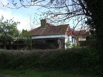
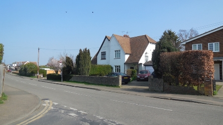
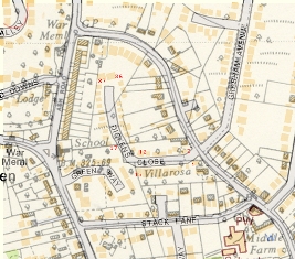 In the past this part of Church Road was much narrower with features such as blind corners to catch out the unwary. The narrowess of the road can be seen in the map which compares the modern map (colour) with the 1955 map (black and while). The postcard shows the road in about 1920 from Stack Lane to the house called "Villa Rosa", near Dickens Close today. Another postcard by Frith shows the road by the RC Church in 1950, where it suddenly narrows, this was not resolved by the County Council until much later. It was very much a country lane with roadside ponds at the end of Stack Lane and outside Mintmakers, both of which have now been filled in.
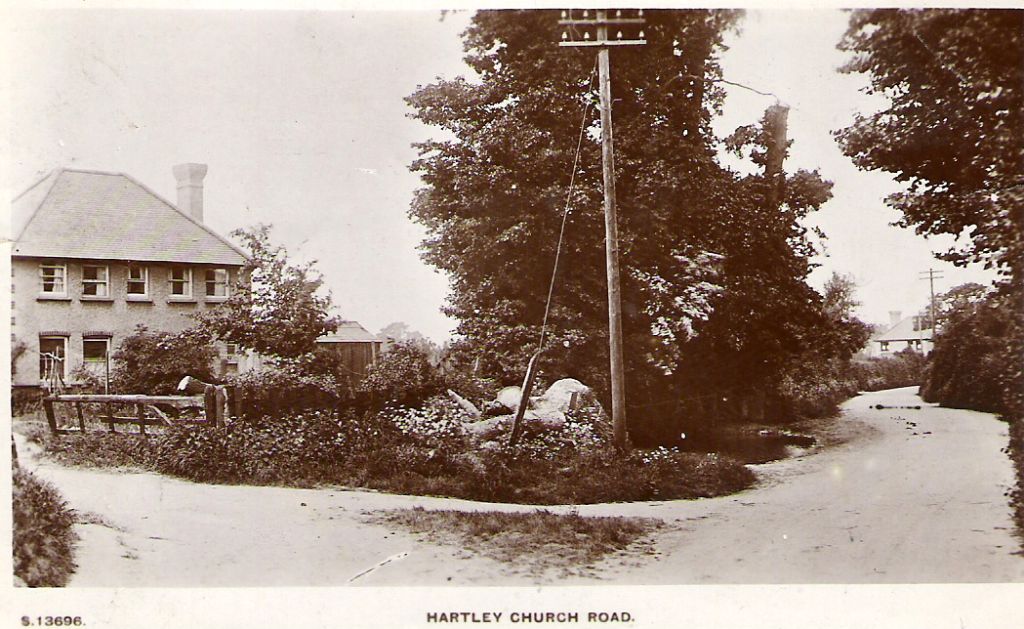
| Subject | Notes |
| Postcode | DA3 8DJ (East side - Ash Road to Gresham Avenue) DA3 8DN (East side - Gresham Avenue to Gorsewood Road) DA3 8DW (East side - Gorsewood Road to Gorse Way) DA3 8DL (West side - Ash Road to Stack Lane) DA3 8DW (West side - Stack Lane to Cherry Trees) |
| KCC Classification | Part of U1118, 1.6 miles (2,625m) adopted |
| Area | 14.00 acres (5.67 ha) |
| Houses | 78 |
| Density | 5.6 houses per acre (13.8 houses per hectare) |
| Population (2021) | 197 (2011 - 200) |
| Average gas consumption (2015) | 21,586 kWh per annum |
| Average electricity consumption (2015) | 5,183 kWh per annum |
| Total gas and electricity consumption (2015) | 26,769 kWh per annum (13th of 61 areas of Hartley) |
Sofia Church Road DA3 8DJ
Detached house (4 bedroom, 227.1 sq m + garage 11.1 sq m) (2019)
Former Name(s): Threeways (1979-2019)
Building History
1979 First Built
1953 Planning Application: (GRANTED) 1953/70 Licensed hotel on corner of Ash Road/Church Road
1961 Planning Application: (GRANTED) 1961/315 Erect licensed premises (applicant Courage & Barclay Limited)
1967 Planning Application: (GRANTED) 1967/563 Pub (Courage)
1977 Planning Application: (GRANTED) 1977/968 Outline Planning Permission For Erection Of 3 Dwellings With Garages
1978 Planning Application: (GRANTED) 1978/77 / 968.1 Three Detached Dwellings Each With Detached Double Garage
2004 Planning Application: (GRANTED) 2004/301 2 storey side extension, replacement garage
2008 Planning Application: (GRANTED) 2008/52 New boundary wall with brick piers and railings
2018 Planning Application: (GRANTED) 2018/1507 Demolition of existing garage/utility to facilitate the erection of a double storey side extension, front extension and elevational changes.
2018 Planning Application: (WITHDRAWN) 2018/3341 Non-material amendment to 18/01507/HOUSE.
2019 Planning Application: (INVALIDATED) 2019/885 Replace garage with 2 storey extension and front extension
Rates and Council Tax
1993 Council Tax: G (£160-320K)
Sales and Rents
2003 Sale Price: £347500 (22 Aug 2003)
2018 Sale Price: £830000 (14 Feb 2018) Planning permission for extension since previous sale Annual percentage change since 2003: +6%
2019 Sale Price: £1040000 (6 Dec 2019) Annual percentage change since 2018: +13%
2009 Rental (per month): £1800.
Site History
1604 Part of Woodins Farm (Upper Well Field 5 acres)
1905 Part of Plots 316-319 Payne and Trapps estate
Ashwood Church Road DA3 8DJ
Detached house (4 bedroom)
Former Name(s): Chateau Neu (to 2012)
Building History
1979 First Built
1953 Planning Application: (GRANTED) 1953/70 Licensed hotel on corner of Ash Road/Church Road
1961 Planning Application: (GRANTED) 1961/315 Erect licensed premises (applicant Courage & Barclay Limited)
1967 Planning Application: (GRANTED) 1967/563 Pub (Courage)
1977 Planning Application: (GRANTED) 1977/968 Outline Planning Permission For Erection Of 3 Dwellings With Garages
1978 Planning Application: (GRANTED) 1978/77 / 968.1 Three Detached Dwellings Each With Detached Double Garage
2012 Planning Application: (GRANTED) 2012/1911 Boundary wall in front
Rates and Council Tax
1993 Council Tax: G (£160-320K)
Sales and Rents
1979 Sale Price: £47950 (16 Jan 1979) Advertised price as "price from" (SE Gazette)
Site History
1604 Part of Woodins Farm (Upper Well Field 5 acres)
1905 Part of Plots 316-319 Payne and Trapps estate
Les Lavandes Church Road DA3 8DJ
Detached house (4 bedroom) (2007)
Former Name(s): Our Place (to 2007)
Building History
1979 First Built
1953 Planning Application: (GRANTED) 1953/70 Licensed hotel on corner of Ash Road/Church Road
1961 Planning Application: (GRANTED) 1961/315 Erect licensed premises (applicant Courage & Barclay Limited)
1967 Planning Application: (GRANTED) 1967/563 Pub (Courage)
1977 Planning Application: (GRANTED) 1977/968 Outline Planning Permission For Erection Of 3 Dwellings With Garages
1978 Planning Application: (GRANTED) 1978/77 / 968.1 Three Detached Dwellings Each With Detached Double Garage
Rates and Council Tax
1993 Council Tax: G (£160-320K) Banding confirmed by Valuation Tribunal 2007
Sales and Rents
1979 Sale Price: £48950 (23 Mar 1979) Advertised Price (Chatham Standard 3.3.1992)
1992 Sale Price: £155000 (3 Mar 1992) Annual percentage change since 1979: +9%
2007 Sale Price: £429950 (3 Apr 2007) Annual percentage change since 1992: +7%
Site History
1604 Part of Woodins Farm (Upper Well Field 5 acres)
1905 Part of Plots 316-319 Payne and Trapps estate
April House Church Road DA3 8DJ
Detached house (4 bedroom, 152.6 sq m + garage 18.6 sq m) (2021)
Building History
1988 First Built
1986 Planning Application: (GRANTED) 1986/1187.1 Erect detached house and garage
Rates and Council Tax
1993 Council Tax: G (£160-320K)
Sales and Rents
2021 Sale Price: £660000 (5 Mar 2021)
Site History
1604 Part of Woodins Farm (Upper Well Field 5 acres)
1905 Plot 320 Payne and Trapps estate
1954 Part of St Margarets, Church Road
Laurels Church Road DA3 8DJ
(2021)
Building History
2021 First Built
2018 Planning Application: (GRANTED) 2018/2334 Construction of detached house with integral garage and associated parking
2018 Planning Application: (N/A) 2018/3793 Details pursuant to condition 3 (soft and hard landscaping) of 18/02334/FUL
2018 Planning Application: (N/A) 2018/3830 Details pursuant to condition 6 (ecology) of 18/02334/FUL
Rates and Council Tax
2021 Council Tax: G (£160-320K)
Sales and Rents
Site History
1604 Part of Woodins Farm (Upper Well Field 5 acres)
1905 Plots 321 and 322 (part) Payne and Trapps estate
St Margarets Church Road DA3 8DJ
Detached chalet bungalow (5 bedroom, 179.1 sq m + garage 27.9 sq m) (2017)
Building History
1954 First Built
2004 Building demolished
2006 Rebuilding
1949 Planning Application: (GRANTED) 1949/346 Erect 2 dwelling houses
1950 Planning Application: (GRANTED) 1950/249 Erect house
1952 Planning Application: (GRANTED) 1952/6569 Private Garage
1966 Planning Application: (GRANTED) 1966/540 Erect house adjacent to
1966 Planning Application: (NOT KNOWN) 1966/540.1 Erect house adjacent to
1977 Planning Application: (GRANTED) 1977/123 Erection Of A Detached Dwelling
1977 Planning Application: (GRANTED) 1977/123 Erect detached dwelling
1981 Planning Application: (GRANTED) 1981/817 Detached house and garage
1983 Planning Application: (GRANTED) 1983/1187 Erect detached dwelling and garage (details following 81/817)
1986 Planning Application: (GRANTED) 1986/1187.1 Erect detached house and garage
2003 Planning Application: (REFUSED) 2003/845 Demolish, replace with 2 dwellings
2003 Planning Application: (GRANTED) 2003/1672 Replacement dwelling
2004 Planning Application: (REFUSED) 2004/278 Detached house
2004 Planning Application: (REFUSED) 2004/1099 Single detached house (see 2003.1672)
2004 Planning Application: (REFUSED) 2004/1817 Vary condition as to demolition in 03/1672
2005 Planning Application: (REFUSED) 2005/841 Erect detached house
2008 Planning Application: (REFUSED) 2008/2947 Erect chalet bungalow on land in front
2011 Planning Application: (REFUSED) 2011/3206 Conversion of integral garage living accommodation and the construction of a detached garage with home office within roof space.
2012 Planning Application: (REFUSED) 2012/606 Conversion of integral garage living accommodation and the construction of a double detached garage to the front of the property.
2013 Planning Application: (REFUSED) 2013/442 Erection of a double garage in the front garden, and the conversion of the existing integral garage into living accommodation.
2014 Planning Application: (REFUSED) 2014/1426 The erection of a detached house with integral garage to the South of St Margarets, and the re-location of the access to the existing dwelling
2014 Planning Application: (GRANTED) 2014/3429 Conversion of existing integral garage into domestic accommodation, and formation of two car parking spaces.
2015 Planning Application: (GRANTED) 2015/898 The erection of a single domestic garage.
2017 Planning Application: (GRANTED) 2017/2845 Erection of detached house with integral garage on vacant plot there
2017 Planning Application: (GRANTED) 2017/4061 Minor material amendment to application SE/17/0845/FUL for the erection of a detached house with integral garage and associated parking to show reconfiguration of the roof on the rear and side elevations.
2018 Planning Application: (GRANTED) 2018/17 Details pursuant to condition 2 (materials) of SE/17/02845/FUL.
2018 Planning Application: (GRANTED) 2018/955 Details pursuant to condition 3 (hard & soft landscaping) of planning permission SE/17/04061/MMA.
2018 Planning Application: (GRANTED) 2018/1011 Details pursuant to condition 4 (boundary treatment) of planning permission SE/17/04061/MMA.
2018 Planning Application: (GRANTED) 2018/1012 Details pursuant to condition 5 (electric vehicle charging point) of planning permission SE/17/04061/MMA.
2018 Planning Application: (GRANTED) 2018/1013 Details pursuant to condition 6 (ecological enhancements) of planning permission SE/17/04061/MMA.
2018 Planning Application: (GRANTED) 2018/2334 Construction of detached house with integral garage and associated parking
2018 Planning Application: (N/A) 2018/3793 Details pursuant to condition 3 (soft and hard landscaping) of 18/02334/FUL
2018 Planning Application: (N/A) 2018/3830 Details pursuant to condition 6 (ecology) of 18/02334/FUL
Rates and Council Tax
1956 Gross Rateable Value: £52
1963 Gross Rateable Value: £148
1972 Gross Rateable Value: £382
2006 Council Tax: G (£160-320K) Formerly Band F (1993-2006)
Sales and Rents
2003 Sale Price: £296000 (2 Apr 2003)
2016 Rental (per month): £2300. pcm
Site History
1604 Part of Woodins Farm (Upper Well Field 5 acres)
1905 Plots 321 and 322 (part) Payne and Trapps estate
Leaf House Church Road DA3 8DJ
Chalet Bungalow (5 bedroom) (2013)
Building History
2000 First Built
1989 Planning Application: (REFUSED) 1989/14 Demolish; replace with 2 detached houses
1991 Planning Application: (REFUSED) 1991/1516 Erection of 3 dwellings (outline)
1995 Planning Application: (REFUSED) 1995/1755 3 detached dwellings
1997 Planning Application: (REFUSED) 1997/944 Construction of 2 No.detached houses with access road
1997 Planning Application: (GRANTED) 1997/1987 2 detached 4 bed houses on land at rear
2000 Planning Application: (GRANTED) 2000/480 Details (landscaping) v 97/1987
2000 Planning Application: (GRANTED) 2000/676 Demolish, replace with 3 bed chalet bungalow
Rates and Council Tax
2000 Council Tax: F (£120-160K)
Sales and Rents
1998 Sale Price: £58500 (24 Mar 1998) Land only
2001 Sale Price: £350000 (27 Apr 2001) Annual percentage change since 1905: +78%
2013 Sale Price: £499950 (21 Jun 2013) Annual percentage change since 1900: +3%
Site History
1604 Part of Woodins Farm (Upper Well Field 5 acres)
1905 Plots 323 and 324 (part) Payne and Trapps estate
1955 Part of The Whinnies, Church Road
Oak Church Road DA3 8DJ
Chalet Bungalow
Building History
2000 First Built
1989 Planning Application: (REFUSED) 1989/14 Demolish; replace with 2 detached houses
1991 Planning Application: (REFUSED) 1991/1516 Erection of 3 dwellings (outline)
1995 Planning Application: (REFUSED) 1995/1755 3 detached dwellings
1997 Planning Application: (REFUSED) 1997/944 Construction of 2 No.detached houses with access road
1997 Planning Application: (GRANTED) 1997/1987 2 detached 4 bed houses on land at rear
2000 Planning Application: (GRANTED) 2000/480 Details (landscaping) v 97/1987
Rates and Council Tax
2000 Council Tax: G (£160-320K)
Sales and Rents
1998 Sale Price: £58500 (24 Mar 1998) Land only
2002 Sale Price: £415000 (7 Aug 2002) Annual percentage change since 1998: +56%
Site History
1604 Part of Woodins Farm (Upper Well Field 5 acres)
1905 Plots 324 and 325 (part) Payne and Trapps estate
1955 Part of The Whinnies, Church Road
The Whinnies Church Road DA3 8DJ
Detached house (4 bedroom, 129 sq m + garage 15 sq m) (2025)
Building History
1955 First Built
2000 Building demolished
2001 Rebuilding
1950 Planning Application: (GRANTED) 1950/299 Erect bungalow on plots 323-324
1989 Planning Application: (REFUSED) 1989/14 Demolish; replace with 2 detached houses
1991 Planning Application: (REFUSED) 1991/1516 Erection of 3 dwellings (outline)
1995 Planning Application: (REFUSED) 1995/1755 3 detached dwellings
1997 Planning Application: (REFUSED) 1997/944 Construction of 2 No.detached houses with access road
1997 Planning Application: (GRANTED) 1997/1987 2 detached 4 bed houses on land at rear
1999 Planning Application: (GRANTED) 1999/522 Demolish, and replace with 3 bed chalet bungalow
2000 Planning Application: (GRANTED) 2000/480 Details (landscaping) v 97/1987
Rates and Council Tax
1956 Gross Rateable Value: £45
1963 Gross Rateable Value: £125
1972 Gross Rateable Value: £312
2001 Council Tax: G (£160-320K) Formerly Band F (1993-2001)
Sales and Rents
1996 Sale Price: £60000 (21 May 1996)
2024 Rental (per month): £2300.
Site History
1604 Part of Woodins Farm (Upper Well Field 5 acres)
1905 Plots 324 and 325 (part) Payne and Trapps estate
Woodins Church Road DA3 8DJ
Detached house (3 bedroom, 137.1 sq m + garage 24.3 sq m + outbuildings 31.8 sq m) (2018)
Former Name(s): Hayes (to 1858)
Former Name(s): Woodins (1858-1874)
Former Name(s): Wilson's Farm (1874-1881)
Former Name(s): Shepherd's Cottage (1881-1953)
Building History
1400 First Built
Not known Rebuilding
1953 Planning Application: (GRANTED) 1953/273 Erect private garage
2017 Planning Application: (GRANTED) 2017/114 Outbuilding erected within the domestic curtilage.
2017 Planning Application: (GRANTED) 2017/177 Alteration to windows in the ground floor of front elevation.
Rates and Council Tax
1956 Gross Rateable Value: £40
1956 Gross Rateable Value: £45
1963 Gross Rateable Value: £130
1972 Gross Rateable Value: £302
1993 Council Tax: F (£120-160K) Formerly Band G
Sales and Rents
1953 Sale Price: £2750 (21 Jul 1953)
1955 Sale Price: £4950 (1 Jan 1955) Advertised price. Seller says they had spent £2,000 improving the place Annual percentage change since 1953: +50%
1956 Sale Price: £4100 (15 Jun 1956) Advertised price (Evening Standard) Annual percentage change since 1955: -12%
2001 Sale Price: £310000 (18 Sep 2001) Annual percentage change since 1956: +10%
2017 Sale Price: £640000 (27 Mar 2017) Annual percentage change since 2001: +5%
1911 Rental (per month): £20.
21/6/1853 Rental (per month): £26.
Site History
Sunnyside Church Road DA3 8DJ
Former Name(s): Conroi (to 1965)
Building History
1926 First Built
1993 Building demolished
1926 Planning Application: (GRANTED) 1926/Meeting 1926-06-01 Concrete block bungalow
1962 Planning Application: (REFUSED) 1962/200 Demolish, replace with 9 dwellings
1962 Planning Application: (REFUSED) 1962/580 Demolition of bungalow, erect 5 detached dwellings
1963 Planning Application: (N/A) 1963/662 Erect detached house or bungalow with 2 garages on land adjoining
1967 Planning Application: (GRANTED) 1967/8 Erect garage
1967 Planning Application: (GRANTED) 1967/376 Erect dwelling adjoining
1967 Planning Application: (N/A) 1967/376.1 (1968) Details of bungalow
1967 Planning Application: (GRANTED) 1967/376.2 Amended details of detached bungalow
1990 Planning Application: (N/A) 1990/808 Loft conversion
1995 Planning Application: (GRANTED) 1995/2090 Detached dwelling
Rates and Council Tax
1956 Gross Rateable Value: £43
1963 Gross Rateable Value: £115
1972 Gross Rateable Value: £262
1993 Council Tax: E (£88-120K) Formerly Band F
Sales and Rents
Site History
1604 Part of Woodins Farm (Barn Field 1 acres)
1905 Plots 327 to 330 (part) Payne and Trapps estate
Ranfolly Church Road DA3 8DJ
Detached house (4 bedroom) (2010)
Building History
1996 First Built
1962 Planning Application: (REFUSED) 1962/580 Erect dwellings on future site of (see Sunnyside)
2018 Planning Application: (WITHDRAWN) 2018/372 Proposed first floor extension to the front south east elevation and new dormer window to the rear north west elevation.
2018 Planning Application: (GRANTED) 2018/1209 Proposed first floor extension to the front south east elevation and porch canopy underneath on ground floor.
Rates and Council Tax
1996 Council Tax: G (£160-320K)
Sales and Rents
1995 Sale Price: £80000 (8 Sep 1995)
1996 Sale Price: £170000 (5 Aug 1996) Annual percentage change since 1995: +129%
2004 Sale Price: £395000 (16 Jan 2004) Annual percentage change since 1996: +12%
Site History
1604 Part of Woodins Farm (Barn Field 1 acres)
1905 Plots 328 (part) Payne and Trapps estate
1926 Part of Sunnyside, Church Road (1926-1996)
Leichvesta Church Road DA3 8DJ
Detached chalet bungalow (3 bedroom, 290.2 sq m + garage 33 sq m) (2022)
Building History
1996 First Built
2015 Planning Application: (GRANTED) 2015/1376 Erection of single storey side extension with chimney to flank elevation.
Rates and Council Tax
1995 Council Tax: G (£160-320K)
Sales and Rents
1994 Sale Price: £62000 (8 Jun 1994)
2022 Sale Price: £1300000 (16 Jun 2022) Annual percentage change since 1994: +11%
Site History
1604 Part of Woodins Farm (Barn Field 1 acres)
1905 Plots 327-328 (part) Payne and Trapps estate
1926 Part of Sunnyside, Church Road (1926-1996)
Beam Ends Church Road DA3 8DJ
Detached chalet bungalow
Building History
1994 First Built
1962 Planning Application: (REFUSED) 1962/580 Erect dwellings on future site of (see Sunnyside)
Rates and Council Tax
1993 Council Tax: G (£160-320K)
Sales and Rents
Site History
1604 Part of Woodins Farm (Barn Field 1 acres)
1905 Plots 328-329 (part) Payne and Trapps estate
1926 Part of Sunnyside, Church Road (1926-1996)
Westwood Church Road DA3 8DJ
Detached bungalow (4 bedroom) (2015)
Former Name(s): Conifers (to 2017)
Building History
1973 First Built
Rates and Council Tax
1993 Council Tax: F (£120-160K)
Sales and Rents
1905 Sale Price: £645000 (9 Jul 1905)
Site History
1604 Part of Woodins Farm (Unnamed Field 2 acres)
1905 Plot 330 Payne and Trapps estate
Church House Church Road DA3 8DJ
Detached Bungalow (3 bedroom)
Former Name(s): Fairways (to 1999)
Building History
1973 First Built
1969 Planning Application: (GRANTED) 1969/382 Erect detached bungalow with garage adjoining Far Ben
2000 Planning Application: (GRANTED) 2000/2127 Additions to entrance hall and garage, convert garage to bedroom
2010 Planning Application: (GRANTED) 2010/3267 Erect infill conservatory (Lawful Development Cert)
Rates and Council Tax
1993 Council Tax: F (£120-160K) With improvement indicator (2025)
Sales and Rents
1925 Sale Price: £700 (6 Oct 1925) Surveyor's valuation for £450 loan to Dartford RDC
1998 Sale Price: £228000 (27 Nov 1998) Annual percentage change since 1925: +8%
Site History
1604 Part of Woodins Farm (Unnamed Field 2 acres)
1905 Plots 331-333 (part) Payne and Trapps estate
1925 Part of Far Ben, Church Road
Far Ben Church Road DA3 8DJ
Detached bungalow (4 bedroom) (2015)
Building History
1925 First Built
1938 Rebuilding
1953 Planning Application: (GRANTED) 1953/326 Use of land adjoining for boarding kennels
1957 Planning Application: (GRANTED) 1957/469 garage
1970 Planning Application: (REFUSED) 1970/440 Detached chalet bungalow on land adjoining
1971 Planning Application: (GRANTED) 1971/230 Garage and bedroom extension at side
1985 Planning Application: (GRANTED) 1985/604 Change of roof line
1987 Planning Application: (GRANTED) 1987/1140 Extensions
2014 Planning Application: (WITHDRAWN) 2014/1896 Single storey rear extension
Rates and Council Tax
1956 Gross Rateable Value: £55
1963 Gross Rateable Value: £155
1972 Gross Rateable Value: £380
1993 Council Tax: G (£160-320K) With improvement indicator (2025)
Sales and Rents
2014 Sale Price: £517500 (19 Dec 2014)
Site History
1604 Part of Woodins Farm (Unnamed Field 2 acres)
1905 Plots 333-334 (part) Payne and Trapps estate
Little Stirrups Church Road DA3 8DJ
Detached chalet bungalow (4 bedroom) (2008)
Building History
1925 First Built
1995 Building demolished
1996 Rebuilding
1925 Planning Application: (GRANTED) 1925/Meeting 1925-07-07 Timber framed bungalow
1994 Planning Application: (GRANTED) 1994/1673 Demolish and erect 2 houses
1995 Planning Application: (GRANTED) 1995/71 Details - demolish and erect 2 houses
1995 Planning Application: (GRANTED) 1995/271 Details - demolish and erect 2 houses
1996 Planning Application: (GRANTED) 1996/561 Details (Boundary treatment) v 94/1673
2015 Planning Application: (GRANTED) 2015/562 Proposed two rear extensions, enlarged porch and internal alterations
Rates and Council Tax
1956 Gross Rateable Value: £36
1963 Gross Rateable Value: £105
1972 Gross Rateable Value: £230
1996 Council Tax: G (£160-320K) Formerly Band F (1993-1996)
Sales and Rents
1927 Sale Price: £550 (1 Jan 1927)
1929 Sale Price: £750 (1 Jan 1929) Annual percentage change since 1927: +17%
1996 Sale Price: £258000 (3 May 1996) Annual percentage change since 1929: +9%
2008 Sale Price: £675000 (24 Apr 2008) Annual percentage change since 1996: +8%
Site History
1604 Part of Woodins Farm (Part of two Unnamed Field 2 acres and ½ acre)
1905 Plots 336-337 Payne and Trapps estate
Ferndale Church Road DA3 8DJ
Detached chalet bungalow (5 bedroom, 242.2 sq m + garage 29.2 sq m + office 14.3 sq m) (2021)
Building History
1995 First Built
1994 Planning Application: (GRANTED) 1994/1673 Demolish and erect 2 houses
1995 Planning Application: (GRANTED) 1995/71 Details - demolish and erect 2 houses
2022 Planning Application: (GRANTED) 2022/664 Proposed ground floor rear extension and alterations to fenestration.
Rates and Council Tax
1993 Council Tax: G (£160-320K) With improvement indicator (2025)
Sales and Rents
1995 Sale Price: £168000 (24 Apr 1995)
1998 Sale Price: £370000 (12 Feb 1998) Advertised price (Sevenoaks Chronicle) Annual percentage change since 1995: +32%
2003 Sale Price: £550000 (6 May 2003) Annual percentage change since 1998: +8%
2005 Sale Price: £590000 (9 Dec 2005) Annual percentage change since 2003: +3%
2021 Sale Price: £1105000 (27 Sep 2021) Annual percentage change since 2005: +4%
Site History
1604 Part of Woodins Farm (Part of two Unnamed Field 2 acres and ½ acre)
1905 Plots 338-339 Payne and Trapps estate
1925 Part of Little Stirrups, Church Road
Cedar Lodge Church Road DA3 8DJ
Building History
2019 First Built
2015 Planning Application: (WITHDRAWN) 2015/3891 Demolition of existing dwelling and erection of 2no. 4-bedroom detached houses each with detached garage, formation of new access
2016 Planning Application: (GRANTED) 2016/2554 Demolition of existing dwelling and erection of 2no. 4-bedroom detached houses each with detached garage, formation of new access.
2016 Planning Application: (GRANTED) 2016/3902 Demolition of existing dwelling and erection of 2no. 4-bedroom detached houses each with detached garage, formation of new access
2017 Planning Application: (GRANTED) 2017/2895 The stationing of a static caravan on a temporary basis for residential purposes.
2018 Planning Application: (GRANTED) 2018/1774 Details pursuant to condition 4 (Full details of tree protection measures to protect existing trees) of planning permission: 16/03902/FUL
2018 Planning Application: (GRANTED) 2018/1887 Alterations to fenestration and internal works v 16/3902)
2019 Planning Application: (N/A) 2019/12 Details pursuant to condition 4 (hard and soft landscaping) of planning permission: 18/01887/MMA.
Rates and Council Tax
1993 Council Tax: G (£160-320K)
Sales and Rents
Site History
1604 Part of Woodins Farm (Part of two Unnamed Field 2 acres and ½ acre)
1905 Plots 340-342 Payne and Trapps estate
Ashton (Grove) Church Road DA3 8DJ
Building History
1957 First Built
2017 Building demolished
1983 Planning Application: (GRANTED) 1983/424 Erection of one detached two storey chalet style dwelling and garage
1988 Planning Application: (GRANTED) 1988/890 Extension and conversion of existing garage dining room
2015 Planning Application: (WITHDRAWN) 2015/3891 Demolition of existing dwelling and erection of 2no. 4-bedroom detached houses each with detached garage, formation of new access
2016 Planning Application: (GRANTED) 2016/2554 Demolition of existing dwelling and erection of 2no. 4-bedroom detached houses each with detached garage, formation of new access.
2016 Planning Application: (GRANTED) 2016/3902 Demolition of existing dwelling and erection of 2no. 4-bedroom detached houses each with detached garage, formation of new access
2017 Planning Application: (GRANTED) 2017/2895 The stationing of a static caravan on a temporary basis for residential purposes.
2018 Planning Application: (GRANTED) 2018/1774 Details pursuant to condition 4 (Full details of tree protection measures to protect existing trees) of planning permission: 16/03902/FUL
2018 Planning Application: (GRANTED) 2018/1887 Alterations to fenestration and internal works v 16/3902)
2019 Planning Application: (N/A) 2019/12 Details pursuant to condition 4 (hard and soft landscaping) of planning permission: 18/01887/MMA.
Rates and Council Tax
1963 Gross Rateable Value: £230
1972 Gross Rateable Value: £592
1993 Council Tax: G (£160-320K)
Sales and Rents
Site History
1604 Part of Woodins Farm (Part of two Unnamed Field 2 acres and ½ acre)
1905 Plots 340-342 Payne and Trapps estate
Willow Tree Cottage Church Road DA3 8DJ
Detached chalet bungalow (4 bedroom 152.2 sq m + garage 22.6 sq m) (2024)
Former Name(s): Brumleigh (1930-1988)
Building History
1930 First Built
1928 Planning Application: (GRANTED) 1928/Meeting 1928-01-03 Amended site to plan 524/B approved by council 9/9/27
1955 Planning Application: (GRANTED) 1955/470 Dwelling on land adjoining
1975 Planning Application: (GRANTED) 1975/249 Erect double garage at side
1984 Planning Application: (N/A) 1984/1509 Demolish and erect 4 chalet bungalows and 1 bungalow
Rates and Council Tax
1956 Gross Rateable Value: £48
1963 Gross Rateable Value: £151
1972 Gross Rateable Value: £343
1993 Council Tax: G (£160-320K) Formerly Band G
Sales and Rents
2004 Sale Price: £410000 (28 May 2004)
2021 Sale Price: £640000 (11 Feb 2021) Annual percentage change since 1900: +3%
Site History
1604 Part of Woodins Farm (Part of two Unnamed Field 2 acres and ½ acre)
1905 Plots 343-344 Payne and Trapps estate
Laxton Church Road DA3 8DJ
Building History
1921 First Built
1986 Building demolished
1984 Planning Application: (N/A) 1984/1509 Demolish and erect 4 chalet bungalows and 1 bungalow
Rates and Council Tax
Sales and Rents
Site History
Hazelwood Church Road DA3 8DJ
Detached bungalow
Building History
1930 First Built
2002 Planning Application: (GRANTED) 2002/1723 Single storey rear extension
Rates and Council Tax
1956 Gross Rateable Value: £41
1963 Gross Rateable Value: £112
1972 Gross Rateable Value: £256
1993 Council Tax: F (£120-160K) With improvement indicator (2025)
Sales and Rents
Site History
Monks Barn Church Road DA3 8DJ
Detached bungalow (5 bedroom)
Building History
1955 First Built
1952 Planning Application: (GRANTED) 1952/120 caravan
1957 Planning Application: (REFUSED) 1957/269 Extension to form shop
1970 Planning Application: (GRANTED) 1970/289 Vehicular access
1987 Planning Application: (GRANTED) 1987/608 Extension
Rates and Council Tax
1956 Gross Rateable Value: £52
1963 Gross Rateable Value: £155
1972 Gross Rateable Value: £408
1993 Council Tax: F (£120-160K)
Sales and Rents
1953 Sale Price: £2225 (7 Apr 1953) Surveyor's valuation for loan under Small Dwellings Acquisition Acts by Dartford RDC of £2,000 over 15 years at 4%
Site History
1604 Part of Middle Farm (part of field called "Little Stirrup", 4½ acres)
1905 Plots 353-354 Payne and Trapps estate
Chelsam Church Road DA3 8DN
Building History
1927 First Built
2013 Building demolished
1927 Planning Application: (GRANTED) 1927/Meeting 1927-04-05 Brick bungalow
2009 Planning Application: (GRANTED) 2009/1424 Demolition of existing dwelling and erection of a detached chalet bungalow and a detached bungalow with alterations to the vehicular access.
2010 Planning Application: (GRANTED) 2010/3522 Demolish, replace with 2 detached dwellings
2011 Planning Application: (GRANTED) 2011/2940 Demolish and replace with 2 chalet bungalows
2012 Planning Application: (REFUSED) 2012/424 Demolish and replace with 2 chalet bungalows
2012 Planning Application: (GRANTED) 2012/3277 Demolish, replaced with 2 semi-detached chalet bungalows
2015 Planning Application: (GRANTED) 2015/2807 Details pursuant to condition 3 (landscaping) of planning permission SE/11/02940
2015 Planning Application: (GRANTED) 2015/2807 Details pursuant to condition 3 (landscaping) of planning permission SE/11/02940
2015 Planning Application: (GRANTED) 2015/2896 Details pursuant to condition 4 (materials) of planning permission SE/11/02940
Rates and Council Tax
1956 Gross Rateable Value: £45
1963 Gross Rateable Value: £114
1972 Gross Rateable Value: £254
Sales and Rents
Site History
Chelsam Church Road DA3 8DN
Terraced house (2 bedroom)
Building History
2014 First Built
Rates and Council Tax
2014 Council Tax: E (£88-120K) Previously Band E (1993-2013)
Sales and Rents
1905 Sale Price: £305000 (6 Jul 1905)
Site History
1625 Part of Middle Farm (part of field called Litte Stirrup, 4½ acres)
1905 Part of plot 356 Payne and Trapps Estate
1927 Part of Chelsam, Church Road
Verbena Church Road DA3 8DN
Terraced house (2 bedroom)
Building History
2014 First Built
Rates and Council Tax
2014 Council Tax: D (£68-88K) Formerly Band E (1993-2014)
Sales and Rents
1905 Sale Price: £305000 (6 Jul 1905)
Site History
1625 Part of Middle Farm (part of field called Litte Stirrup, 4½ acres)
1905 Part of plot 357 Payne and Trapps Estate
1927 Part of Chelsam, Church Road
Keston Church Road DA3 8DN
Detached bungalow (2 bedroom, 151 sq m) (2023)
Building History
1927 First Built
1927 Planning Application: (GRANTED) 1927/Meeting 1927-04-05 Brick bungalow
1970 Planning Application: (GRANTED) 1970/104 Garage
1986 Planning Application: (GRANTED) 1986/1041 Granny Annexe
2013 Planning Application: (GRANTED) 2013/2516 Front porch
Rates and Council Tax
1956 Gross Rateable Value: £40
1963 Gross Rateable Value: £115
1972 Gross Rateable Value: £206
2009 Council Tax: F (£120-160K) Formerly Band F (1993-1997); Band E (1997-2009)
Sales and Rents
2008 Sale Price: £432000 (20 Jun 2008) Advertised £455,000 (8/6/2007)
Site History
1625 Part of Middle Farm (part of field called Litte Stirrup, 4½ acres)
1905 Part of plots 358-359 Payne and Trapps Estate
Keston Annexe Church Road DA3 8DN
Building History
1986 First Built
Rates and Council Tax
1997 Council Tax: A (£0-40K) Removed from list 2009
Sales and Rents
Site History
Windermere Church Road DA3 8DN
Detached bungalow (3 bedroom) (2006)
Building History
1927 First Built
1927 Planning Application: (GRANTED) 1927/Meeting 1927-04-05 Brick bungalow
1953 Planning Application: (GRANTED) 1953/6853 Private garage
1987 Planning Application: (GRANTED) 1987/1427 Rear and garage extension
Rates and Council Tax
1956 Gross Rateable Value: £43
1963 Gross Rateable Value: £121
1972 Gross Rateable Value: £277
1993 Council Tax: F (£120-160K) With improvement indicator (2025)
Sales and Rents
2006 Sale Price: £390000 (26 Oct 2006)
Site History
1625 Part of Middle Farm (part of field called Litte Stirrup, 4½ acres)
1905 Part of plots 360-361 Payne and Trapps Estate
Marsworth Church Road DA3 8DN
Detached house (4 bedroom, 118 sq m) (2023)
Former Name(s): Bayonne (to 1960)
Building History
1927 First Built
1927 Planning Application: (GRANTED) 1927/Meeting 1927-04-05 Brick bungalow
1987 Planning Application: (GRANTED) 1987/568 Extension
2006 Planning Application: (REFUSED) 2006/1872 Addition of first floor to bungalow
2006 Planning Application: (GRANTED) 2006/2880 Add first floor to bungalow
2007 Planning Application: (GRANTED) 2007/2268 Details pursuant to condition 2 (materials) of SE/06/02880/FUL
2007 Planning Application: (GRANTED) 2007/3704 Nine velux windows.
2022 Planning Application: (GRANTED) 2022/2905 Single storey rear/ side extension
Rates and Council Tax
1956 Gross Rateable Value: £39
1963 Gross Rateable Value: £119
1972 Gross Rateable Value: £263
1993 Council Tax: F (£120-160K)
Sales and Rents
1993 Sale Price: £133500 (6 Aug 1993) Mentioned in Valuation Tribunal appeal for Dawsland, Church Road (2023)
2003 Sale Price: £355000 (24 Jul 2003) Annual percentage change since 1900: +10%
Site History
1625 Part of Middle Farm (part of field called Litte Stirrup, 4½ acres)
1905 Part of plots 362-363 Payne and Trapps Estate
Kirkham Church Road DA3 8DN
Detached house
Building History
1911 First Built
1958 Planning Application: (GRANTED) 1958/139 Use of lean to conservatory for ladies' hairdressing
1961 Planning Application: (GRANTED) 1961/291 Additions to hairdressing salon & living room
1965 Planning Application: (GRANTED) 1965/452 Change of use of part from ladies hairdressing to office.
1965 Planning Application: (GRANTED) 1965/599 Alterations to windows and addition of porches
Rates and Council Tax
1956 Gross Rateable Value: £55
1963 Gross Rateable Value: £240
1972 Gross Rateable Value: £550
1993 Council Tax: G (£160-320K)
Sales and Rents
Site History
1625 Part of Middle Farm (partly in a field called Litte Stirrup, 4½ acres, other part in a field called Great Stirrup, 9 acres)
1905 Part of plots 364-365 Payne and Trapps Estate
Brambleberry Church Road DA3 8DN
Detached house
Building History
1982 First Built
1967 Planning Application: (GRANTED) 1967/564 Erect 2 detached houses, 1 det bungalow with garages on land adjoining the Elms
Rates and Council Tax
1972 Gross Rateable Value: £500
1993 Council Tax: G (£160-320K)
Sales and Rents
1982 Sale Price: £20000 (30 Apr 1982) Land only
Site History
1625 Part of Middle Farm (part of a field called Great Stirrup, 9 acres)
1905 Part of plots 366-367 Payne and Trapps Estate
1911 Part of Kirkham, Church Road
Copperdene Church Road DA3 8DN
Detached house
Building History
1973 First Built
1962 Planning Application: (GRANTED) 1962/106 Erect dwelling on land adjoining The Elms
1967 Planning Application: (GRANTED) 1967/564 Erect 2 detached houses, 1 det bungalow with garages on land adjoining the Elms
1971 Planning Application: (GRANTED) 1971/258 Rear kitchen, dining room extension
1971 Planning Application: (GRANTED) 1971/525 Erect 2 storey kitchen, dining room, bedroom extension at rear
Rates and Council Tax
1993 Council Tax: F (£120-160K)
Sales and Rents
2003 Sale Price: £270000 (14 Mar 2003)
Site History
1625 Part of Middle Farm (part of a field called Great Stirrup, 9 acres)
1905 Part of plots 368-369 Payne and Trapps Estate
1911 Part of The Elms, Church Road
Pinewood Church Road DA3 8DN
Detached house (5 bedroom, 153 sq m) (2023)
Building History
1973 First Built
1962 Planning Application: (GRANTED) 1962/106 Erect dwelling on land adjoining The Elms
1967 Planning Application: (GRANTED) 1967/564 Erect 2 detached houses, 1 det bungalow with garages on land adjoining the Elms
1971 Planning Application: (GRANTED) 1971/352 Rear kitchen, dining room extension
1971 Planning Application: (GRANTED) 1971/526 Erect 2 storey kitchen, dining room, bedroom extension at rear
1982 Planning Application: (GRANTED) 1982/1114 Extension To Dwelling
Rates and Council Tax
1972 Gross Rateable Value: £360
1993 Council Tax: F (£120-160K)
Sales and Rents
Site History
1625 Part of Middle Farm (part of a field called Great Stirrup, 9 acres)
1905 Part of plots 369-370 Payne and Trapps Estate
1911 Part of The Elms, Church Road
The Elms Church Road DA3 8DN
Detached chalet bungalow (5 bedroom, 196.4 sq m + garage 23.7 sq m) (2021)
Former Name(s): The Elms (to 1939); The Laburnums (uncertain date)
Building History
1911 First Built
1968 Rebuilding
1959 Planning Application: (REFUSED) 1959/127 Erect 2 shops and bungalow adjoining
1962 Planning Application: (GRANTED) 1962/106 Erect dwelling on land adjoining The Elms
1966 Planning Application: (ENFORCEMENT) 1966/NP3/068 Town and Country Planning Act 1968 Section 15 2 X Enforcement Notices dated 07/10/1966 requiring (1) the discontinuance of the use of the land for the parking of motor vehicles, plant and mechanical equipment and the storing of ancillary materials and equipment. (2) The restoration of the boundary between the land and Church Road to close the new access. To be completed within 61 days of the date on which these notices take effect. These notices take effect on 13/11/1966
1967 Planning Application: (GRANTED) 1967/353 Erect 3 detached houses and integral garages
1969 Planning Application: (N/A) 1969/321 Erect garage, alter porch, erect covered way and false chimney, new vehicular access
2022 Planning Application: (GRANTED) 2022/135 Demolition of existing attached garage and building of enlarged single storey side extension with roof lights and alterations to fenestration
Rates and Council Tax
1956 Gross Rateable Value: £39
1963 Gross Rateable Value: £105
1972 Gross Rateable Value: £240
1993 Council Tax: G (£160-320K)
Sales and Rents
1968 Sale Price: £5000 (3 Oct 1968)
2001 Sale Price: £263000 (8 Jun 2001) Annual percentage change since 1968: +13%
2021 Sale Price: £660000 (21 Sep 2021) Annual percentage change since 1968: +10%
Site History
1625 Part of Middle Farm (part of a field called Great Stirrup, 9 acres)
1905 Part of plots 371-373 Payne and Trapps Estate
Preet Niwas Church Road DA3 8DN
Former Name(s): Spinney Corner (1930); Spinney Corner Home for Destitute Girls (1939); Convent (1943-1978)
Building History
1930 First Built. I think the name means "lovely house"
1968 Rebuilt
2015 Building demolished
1968 Planning Application: (GRANTED) 1968/582 Demolish and replace Convent of Sisters of Mercy
1978 Planning Application: (REFUSED) 1978/263 Demolition Of Existing Building And Erection Of 14 Detached Dwellings With Garages
2014 Planning Application: (GRANTED) 2014/3251 Demolition of existing dwelling and garage, and erection of two four bedroom detached dwellings and one three bedroom bungalow with associated revised access to Church Road.
2015 Planning Application: (GRANTED) 2015/777 Details purusant to condition 7 (biodiversity) of SE/14/03251/FUL
2015 Planning Application: (WITHDRAWN) 2015/1306 Details pursuant to condition 2 (materials) of SE/14/03251/FUL
2015 Planning Application: (GRANTED) 2015/1307 Details pursuant to condition 3 (slab levels) of SE/14/03251/FUL
2015 Planning Application: (GRANTED) 2015/1308 Details pursuant to condition 4 (landscaping) of SE/14/03251/FUL
2015 Planning Application: (WITHDRAWN) 2015/1309 Details pursuant to condition 6 part i (code for sustainable homes) of SE/14/03251/FUL
2015 Planning Application: (GRANTED) 2015/1310 Details pursuant to condition 11 (footway/vehicular crossing) of SE/14/03251/FUL
2015 Planning Application: (WITHDRAWN) 2015/1311 Details pursuant to condition 14 (external lighting) of SE/14/03251/FUL
2015 Planning Application: (GRANTED) 2015/1312 Details pursuant to condition 15 (method statement) of SE/14/03251/FUL
2015 Planning Application: (GRANTED) 2015/2142 Details pursuant to condition 2 (materials) of SE/14/03251/FUL
2015 Planning Application: (GRANTED) 2015/2143 Details pursuant to condition 6 part i (code for sustainable homes) of SE/14/03251/FUL
2015 Planning Application: (GRANTED) 2015/2144 Details pursuant to condition 14 (external lighting) of SE/14/03251/FUL
2015 Planning Application: (GRANTED) 2015/3264 Erection of a pair of two bedroom bungalows
2016 Planning Application: (GRANTED) 2016/730 Details pursuant to condition 3 (proposed slab levels) of SE/15/03264/FUL.
2016 Planning Application: (GRANTED) 2016/730 Details pursuant to condition 4 (hard and soft landscaping) of SE/15/03264
2016 Planning Application: (WITHDRAWN) 2016/732 Details pursuant to condition 11 (construction method statement) of SE/15/03264
2016 Planning Application: (GRANTED) 2016/1168 Details pursuant to condition 6 (biodiversity) of planning permission SE/15/03264/FUL
2016 Planning Application: (GRANTED) 2016/3600 Minor Material Amendment to SE/15/032641/FUL (Erection of a pair of two bedroom bungalows) to show addition of conservatory.
2017 Planning Application: (GRANTED) 2017/363 Minor Material Amendment to SE/15/03264/FUL for erection of a pair of two bedroom bungalow to include a conservatory to rear of Plot 4
Rates and Council Tax
1956 Gross Rateable Value: £260
1963 Gross Rateable Value: £440
1972 Gross Rateable Value: £1700
1993 Council Tax: G (£160-320K)
Sales and Rents
Site History
1625 Part of Middle Farm (part of a field called Great Stirrup, 9 acres)
1905 Part of plots 374-381 Payne and Trapps Estate
Beaumont Church Road DA3 8DN
Detached House (2016)
Detached House
Building History
Building History
2016 First Built
2016 First Built
2015 Planning Application: (GRANTED) 2015/777 Details purusant to condition 7 (biodiversity) of SE/14/03251/FUL
2015 Planning Application: (WITHDRAWN) 2015/1306 Details pursuant to condition 2 (materials) of SE/14/03251/FUL
2015 Planning Application: (GRANTED) 2015/1307 Details pursuant to condition 3 (slab levels) of SE/14/03251/FUL
2015 Planning Application: (GRANTED) 2015/1308 Details pursuant to condition 4 (landscaping) of SE/14/03251/FUL
2015 Planning Application: (WITHDRAWN) 2015/1309 Details pursuant to condition 6 part i (code for sustainable homes) of SE/14/03251/FUL
2015 Planning Application: (GRANTED) 2015/1310 Details pursuant to condition 11 (footway/vehicular crossing) of SE/14/03251/FUL
2015 Planning Application: (WITHDRAWN) 2015/1311 Details pursuant to condition 14 (external lighting) of SE/14/03251/FUL
2015 Planning Application: (GRANTED) 2015/1312 Details pursuant to condition 15 (method statement) of SE/14/03251/FUL
2015 Planning Application: (GRANTED) 2015/2142 Details pursuant to condition 2 (materials) of SE/14/03251/FUL
2015 Planning Application: (GRANTED) 2015/2143 Details pursuant to condition 6 part i (code for sustainable homes) of SE/14/03251/FUL
2015 Planning Application: (GRANTED) 2015/2144 Details pursuant to condition 14 (external lighting) of SE/14/03251/FUL
2015 Planning Application: (GRANTED) 2015/3264 Erection of a pair of two bedroom bungalows
2016 Planning Application: (GRANTED) 2016/730 Details pursuant to condition 3 (proposed slab levels) of SE/15/03264/FUL.
2016 Planning Application: (GRANTED) 2016/730 Details pursuant to condition 4 (hard and soft landscaping) of SE/15/03264
2016 Planning Application: (WITHDRAWN) 2016/732 Details pursuant to condition 11 (construction method statement) of SE/15/03264
2016 Planning Application: (GRANTED) 2016/1168 Details pursuant to condition 6 (biodiversity) of planning permission SE/15/03264/FUL
2016 Planning Application: (GRANTED) 2016/3600 Minor Material Amendment to SE/15/032641/FUL (Erection of a pair of two bedroom bungalows) to show addition of conservatory.
2017 Planning Application: (GRANTED) 2017/363 Minor Material Amendment to SE/15/03264/FUL for erection of a pair of two bedroom bungalow to include a conservatory to rear of Plot 4
Rates and Council Tax
Building History
2016 Council Tax: G (£160-320K)
Sales and Rents
Rates and Council Tax
2016 Sale Price: £665000 (14 Nov 2016)
Site History
Sales and Rents
1625 Part of Middle Farm (part of a field called Great Stirrup, 9 acres)
1625 Part of Middle Farm (part of a field called Great Stirrup, 9 acres)
1905 Part of plots 378-379 Payne and Trapps Estate
1905 Part of plots 374-381 Payne and Trapps Estate
1930 Built on land formerly part of Preet Niwas, Church Road
1930 Part of Preet Niwas, Church Road
Courtlands Church Road DA3 8DN
Detached House (4 bedroom) (2017)
Detached house
Building History
Building History
2016 First Built
2016 First Built
2015 Planning Application: (GRANTED) 2015/777 Details purusant to condition 7 (biodiversity) of SE/14/03251/FUL
2015 Planning Application: (WITHDRAWN) 2015/1306 Details pursuant to condition 2 (materials) of SE/14/03251/FUL
2015 Planning Application: (GRANTED) 2015/1307 Details pursuant to condition 3 (slab levels) of SE/14/03251/FUL
2015 Planning Application: (GRANTED) 2015/1308 Details pursuant to condition 4 (landscaping) of SE/14/03251/FUL
2015 Planning Application: (WITHDRAWN) 2015/1309 Details pursuant to condition 6 part i (code for sustainable homes) of SE/14/03251/FUL
2015 Planning Application: (GRANTED) 2015/1310 Details pursuant to condition 11 (footway/vehicular crossing) of SE/14/03251/FUL
2015 Planning Application: (WITHDRAWN) 2015/1311 Details pursuant to condition 14 (external lighting) of SE/14/03251/FUL
2015 Planning Application: (GRANTED) 2015/1312 Details pursuant to condition 15 (method statement) of SE/14/03251/FUL
2015 Planning Application: (GRANTED) 2015/2142 Details pursuant to condition 2 (materials) of SE/14/03251/FUL
2015 Planning Application: (GRANTED) 2015/2143 Details pursuant to condition 6 part i (code for sustainable homes) of SE/14/03251/FUL
2015 Planning Application: (GRANTED) 2015/2144 Details pursuant to condition 14 (external lighting) of SE/14/03251/FUL
2015 Planning Application: (GRANTED) 2015/3264 Erection of a pair of two bedroom bungalows
2016 Planning Application: (GRANTED) 2016/730 Details pursuant to condition 3 (proposed slab levels) of SE/15/03264/FUL.
2016 Planning Application: (GRANTED) 2016/730 Details pursuant to condition 4 (hard and soft landscaping) of SE/15/03264
2016 Planning Application: (WITHDRAWN) 2016/732 Details pursuant to condition 11 (construction method statement) of SE/15/03264
2016 Planning Application: (GRANTED) 2016/1168 Details pursuant to condition 6 (biodiversity) of planning permission SE/15/03264/FUL
2016 Planning Application: (GRANTED) 2016/3600 Minor Material Amendment to SE/15/032641/FUL (Erection of a pair of two bedroom bungalows) to show addition of conservatory.
2017 Planning Application: (GRANTED) 2017/363 Minor Material Amendment to SE/15/03264/FUL for erection of a pair of two bedroom bungalow to include a conservatory to rear of Plot 4
Rates and Council Tax
Building History
2016 Council Tax: G (£160-320K)
Sales and Rents
Rates and Council Tax
2016 Sale Price: £725000 (16 Dec 2016)
Site History
Sales and Rents
1625 Part of Middle Farm (part of a field called Great Stirrup, 9 acres)
1625 Part of Middle Farm (part of a field called Great Stirrup, 9 acres)
1905 Part of plots 380-381 Payne and Trapps Estate
1905 Part of plots 374-381 Payne and Trapps Estate
1930 Built on land formerly part of Preet Niwas, Church Road
1930 Part of Preet Niwas, Church Road
St Adwen Church Road DA3 8DN
Detached chalet bungalow (3 bedroom) (2006)
Building History
1941 First Built. St Adwen is the local saint for the parish of Advent in Cornwall
Rates and Council Tax
1956 Gross Rateable Value: £45
1963 Gross Rateable Value: £133
1972 Gross Rateable Value: £284
1993 Council Tax: F (£120-160K)
Sales and Rents
1976 Sale Price: £26500 (2 Dec 1976)
2006 Sale Price: £320000 (22 Aug 2006) Annual percentage change since 1976: +9%
Site History
1625 Part of Middle Farm (part of a field called Great Stirrup, 9 acres)
1905 Part of plots 382-383 Payne and Trapps Estate
Pickwick Church Road DA3 8DN
Detached house (2 bedroom, 107 sq m) (2023)
Building History
1976 First Built
1975 Planning Application: (REFUSED) 1975/1316 Erection Of A Detached Chalet Bungalow
2004 Planning Application: (GRANTED) 2004/3132 2 storey rear extension for kitchen, dining room, bedroom
2009 Planning Application: (GRANTED) 2009/1464 Reconductor existing low voltage overhead lines with aerial bundled conductor
Rates and Council Tax
1993 Council Tax: F (£120-160K)
Sales and Rents
Site History
1625 Part of Middle Farm (part of a field called Great Stirrup, 9 acres)
1905 Part of plot 384 Payne and Trapps Estate
1941 Part of St Adwen, Church Road
Cherry Wood Church Road DA3 8DW
Detached bungalow (3 bedroom, 150 sq m) (2023)
Former Name(s): Downie Mount (to 2011)
Building History
1955 First Built
1949 Planning Application: (GRANTED) 1949/475 Erect bungalow
1962 Planning Application: (REFUSED) 1962/283 Detached bungalow on land adjoining
1962 Planning Application: (GRANTED) 1962/411 Erect detached bungalow adjoining Downie Mount
Rates and Council Tax
1956 Gross Rateable Value: £60
1963 Gross Rateable Value: £200
1972 Gross Rateable Value: £552
1993 Council Tax: G (£160-320K)
Sales and Rents
1994 Sale Price: £155000 (6 Jan 1994) Mentioned in Valuation Tribunal appeal for Dawsland Church Road
2011 Sale Price: £370000 (4 Oct 2011) Annual percentage change since 1900: +5%
Site History
1604 Part of 2 farms: Blue House Farm (Chuckle Field, 1½ acres); Hartley Court (Upper North Field, 20 acres)
1912 Part of Smallowners Limited Johns smallholding
Enchante Church Road DA3 8DW
Detached bungalow (3 bedroom) (2020)
Building History
1962 First Built
1962 Planning Application: (GRANTED) 1962/411 Erect detached bungalow adjoining Downie Mount
1999 Planning Application: (GRANTED) 1999/1977 Conservatory
2010 Planning Application: (GRANTED) 2010/542 4 dormers and velux at front, 4 dormers at rear
2014 Planning Application: (GRANTED) 2014/137 Loft conversion with dormers & velux windows
2018 Planning Application: (GRANTED) 2018/858 Demolition of existing bungalow, garage and shed and erection of 2 detached houses.
Rates and Council Tax
1972 Gross Rateable Value: £509
1993 Council Tax: G (£160-320K)
Sales and Rents
2009 Sale Price: £465000 (17 Dec 2009)
Site History
1604 Part of 2 farms: Blue House Farm (Chuckle Field, 1½ acres); Hartley Court (Upper North Field, 20 acres)
1912 Part of Smallowners Limited Johns smallholding
1955 Part of Cherrywood, Church Road
Felsted Church Road DA3 8DW
Semi-detached house (4 bedroom). In 1944 said to be 3 bed (2017)
Building History
1931 First Built
1931 Planning Application: (GRANTED) 1931/Meeting 1931-01-06 2 storey brick dwelling houses
1978 Planning Application: (GRANTED) 1978/314 Extension To Rear Of Dwelling And Erection Of Detached Double Garage At Side
1988 Planning Application: (GRANTED) 1988/2192 2 storey side extension
Rates and Council Tax
1956 Gross Rateable Value: £46
1963 Gross Rateable Value: £130
1972 Gross Rateable Value: £295
1993 Council Tax: F (£120-160K) Formerly Band E (1993-2024)
Sales and Rents
1944 Sale Price: £1900 (22 Sep 1944) Advertised price
2017 Sale Price: £538500 (18 Sep 2017) Marketed £575,000 Annual percentage change since 1944: +8%
Site History
1604 Part of 2 farms: Blue House Farm (Chuckle Field, 1½ acres); Hartley Court (Upper North Field, 20 acres)
1912 Part of Smallowners Limited Johns smallholding
Doverhay Church Road DA3 8DW
Semi-detached house (3 bedroom, 112.5 sq m + garage 37.8 sq m) (2021)
Building History
1931 First Built
1931 Planning Application: (GRANTED) 1931/Meeting 1931-01-06 2 storey brick dwelling houses
Rates and Council Tax
1956 Gross Rateable Value: £45
1963 Gross Rateable Value: £128
1972 Gross Rateable Value: £307
1993 Council Tax: E (£88-120K)
Sales and Rents
2001 Sale Price: £220000 (12 Oct 2001)
2021 Sale Price: £529000 (23 Jun 2021) Annual percentage change since 1900: +5%
Site History
1604 Part of 2 farms: Blue House Farm (Chuckle Field, 1½ acres); Hartley Court (Upper North Field, 20 acres)
1912 Part of Smallowners Limited Johns smallholding
Avian Church Road DA3 8DW
Building History
1924 First Built
1974 Building demolished
1924 Planning Application: (GRANTED) 1924/Meeting 1924-04-24 2 bungalows
1953 Planning Application: (GRANTED) 1953/6683 Construction of 2 rooms in roof and staircase
Rates and Council Tax
1956 Gross Rateable Value: £43
1963 Gross Rateable Value: £120
1972 Gross Rateable Value: £267
Sales and Rents
Site History
1604 Part of 2 farms: Blue House Farm (Chuckle Field, 1½ acres); Hartley Court (Upper North Field, 20 acres)
1923 Part of Smallowners Limited north side of Gorse Way smallholding
Silvercrest Church Road DA3 8DW
Detached house (4 bedroom, 217.6 sq m) (2021)
Former Name(s): Maycroft (to 1999)
Building History
1974 First Built
2005 Planning Application: (GRANTED) 2005/1685 Convert garage to room
2006 Planning Application: (GRANTED) 2006/3067 single storey rear extension (v 05/1685)
Rates and Council Tax
1999 Council Tax: G (£160-320K) Confirmed by Valuation Tribunal 1999. With improvement indicator (2025)
Sales and Rents
1997 Sale Price: £137000 (21 Feb 1997)
1999 Sale Price: £177000 (7 May 1999) Annual percentage change since 1997: +12%
2022 Sale Price: £670000 (30 Sep 2022) Annual percentage change since 1999: +6%
Site History
1604 Part of Blue House Farm (Chuckle Field, 1½ acres)
1923 Part of Smallowners Limited north side of Gorse Way smallholding
Amberleigh Church Road DA3 8DW
Detached house (4 bedroom, 170 sq m) (2021)
Building History
1974 First Built
1975 Planning Application: (REFUSED) 1975/1193 Erection Of Double Garage Extension At Front
Rates and Council Tax
1993 Council Tax: G (£160-320K) Confirmed by Valuation Tribunal appeal
Sales and Rents
1974 Sale Price: £24500 (31 Jul 1974)
1980 Sale Price: £67500 (31 Jan 1980) Marketed at £67,500 (Jan 1980) Annual percentage change since 1974: +20%
1996 Sale Price: £150000 (29 Nov 1996) Annual percentage change since 1980: +5%
2012 Sale Price: £412500 (29 Feb 2012) Annual percentage change since 1996: +7%
Site History
1604 Part of Blue House Farm (Chuckle Field, 1½ acres)
1923 Part of Smallowners Limited north side of Gorse Way smallholding
Maplecroft Church Road DA3 8DW
Detached house (5 bedroom) (2015)
Building History
1976 First Built
1995 Planning Application: (N/A) 1995/23 Detached garage
1995 Planning Application: (N/A) 1995/123 Detached garage
2017 Planning Application: (REFUSED) 2017/1763 Telecommunications equipment on land west of
2018 Planning Application: (N/A) 2018/3452 Part garage conversion. Addition of rooflights.
2019 Planning Application: (GRANTED) 2019/118 Single storey side extension. Part garage conversion.
Rates and Council Tax
1993 Council Tax: G (£160-320K)
Sales and Rents
2014 Sale Price: £475000 (12 Sep 2014)
2018 Sale Price: £650000 (3 Aug 2018) Annual percentage change since 2014: +8%
Site History
1604 Part of Blue House Farm (Chuckle Field, 1½ acres)
1923 Part of Smallowners Limited north side of Gorse Way smallholding
Lisieux Church Road DA3 8DW
Detached house
Building History
1924 First Built
1976 Rebuilding
1924 Planning Application: (GRANTED) 1924/Meeting 1924-04-24 2 bungalows
Rates and Council Tax
1956 Gross Rateable Value: £39
1963 Gross Rateable Value: £120
1972 Gross Rateable Value: £281
1993 Council Tax: E (£88-120K)
Sales and Rents
Site History
1604 Part of 2 farms: Blue House Farm (Chuckle Field, 1½ acres); Hartley Court (Upper North Field, 20 acres)
1923 Part of Smallowners Limited north side of Gorse Way smallholding
Bests Cottages (demolished) Church Road DA3 8DW
Building History
1858 First Built
1903 Building demolished by order of Dartford Rural District Council
Rates and Council Tax
Sales and Rents
Site History
Site History
1 Church Road DA3 8DL
Shop and flat over (2 bedroom, 77.2 sq m)
Building History
1935 First Built
1934 Planning Application: (GRANTED) 1934/Meeting 1934-03-06 5 shops and dwelling houses
1975 Planning Application: (N/A) 1975/1093 Demolish garage and erect 2s side extension to provide more shop space with kitchen and lounge at rear
1983 Planning Application: (GRANTED) 1983/309 Use part of 1st floor as hairdressing salon
1983 Planning Application: (GRANTED) 1983/1340 Single storey extension to form staff room
1985 Planning Application: (GRANTED) 1985/1861 Change of use to office
1988 Planning Application: (GRANTED) 1988/568 Rear extension, roof covering to open yard, modification of shopfront
1989 Planning Application: (GRANTED) 1989/568 Rear extension roof covering to yard, modify shop front
1990 Planning Application: (REFUSED) 1990/1852 Change of use from A1 (plant hire) to A3 (restaurant)
1991 Planning Application: (REFUSED) 1991/1405 Change of use from A1 (plant hire) to A3 (restaurant)
1992 Planning Application: (GRANTED) 1992/163 Use upper floor for residential only
2006 Planning Application: (GRANTED) 2006/2970 Change of use from A1 to A2 Financial Services Office
2007 Planning Application: (GRANTED) 2007/2363 Erect fascia sign
2008 Planning Application: (REFUSED) 2008/3240 Erect building to be A2 business/flat
2009 Planning Application: (GRANTED) 2009/1179 Erection of a building to be used as A2 offices at ground floor and self-contained apartment at 1st floor
2011 Planning Application: (GRANTED) 2011/1056 Erect building to be A2 business/flat
2014 Planning Application: (GRANTED) 2014/1769 Details (materials) v 11/1056
2014 Planning Application: (GRANTED) 2014/1814 Details (landscaping) v 11/1056
2014 Planning Application: (GRANTED) 2014/1815 Details (boundary treatment) v 11/1056
Rates and Council Tax
1956 Gross Rateable Value: £52
1963 Gross Rateable Value: £98
1972 Gross Rateable Value: £325
1993 Council Tax: C (£52-68K)
Sales and Rents
1972 Sale Price: £12000 (19 Apr 1972) Advertised price
2007 Sale Price: £350000 (9 Nov 2007) Annual percentage change since 1972: +10%
2012 Sale Price: £575000 (6 Dec 2012) Probably advertised price Annual percentage change since 2007: +10%
2008 Rental (per month): £700.
2011 Rental (per month): £695.
2019 Rental (per month): £975.
Site History
1604 Part of Woodins Farm (part Hays Field, 6 acres)
1912 Part of Rochford smallholding
1 (business) Church Road DA3 8DL
Building History
1935 First Built
Rates and Council Tax
1995 Gross Rateable Value: £5000
2000 Gross Rateable Value: £6100
2005 Gross Rateable Value: £5600
2017 Gross Rateable Value: £7600
2023 Gross Rateable Value: £10500
Sales and Rents
Site History
Business Occupiers
1939 Sizers (Butchers)
1978 Hartley Supplies and Plant Hire
2008 Clifton & Co (Estate Agents)
2 Church Road DA3 8DL
Shop and flat over (4 bedroom)
Building History
1935 First Built
1965 Planning Application: (GRANTED) 1965/271 Erect private garage
1994 Planning Application: (GRANTED) 1994/584 Extensions and alterations to shop front
1997 Planning Application: (GRANTED) 1997/482 Details (materials) v 94/584
2009 Planning Application: (REFUSED) 2009/2670 Lawful development certificate for use as off licence and residential accommodation
2010 Planning Application: (GRANTED) 2010/343 Lawful development certificate for use as off licence and residential accommodation
2010 Planning Application: (GRANTED) 2010/1405 Expand shop, extend living accommodation; new shop front
2011 Planning Application: (GRANTED) 2011/30 Change of use of part from residential to A1 retail use
2011 Planning Application: (GRANTED) 2011/55 Externally illuminated fascia sign
2011 Planning Application: (GRANTED) 2011/1244 Details (materials) v 10/1405
2011 Planning Application: (GRANTED) 2011/1271 Details (hard landscaping) v 10/1405
2011 Planning Application: (GRANTED) 2011/1272 Details (boundary treatment) to 10/1405
2012 Planning Application: (GRANTED) 2012/666 Provision of dormer window in rear roof slope
2012 Planning Application: (GRANTED) 2012/898 Variation of condition 2 (approved plans) v 11/30
2012 Planning Application: (GRANTED) 2012/1410 First floor extension at rear
Rates and Council Tax
1956 Gross Rateable Value: £52
1963 Gross Rateable Value: £98
1972 Gross Rateable Value: £500
2017 Gross Rateable Value: £2175
2023 Gross Rateable Value: £3050
2022 Council Tax: C (£52-68K) Formerly Band B (1993-2022)
Sales and Rents
1964 Sale Price: £7750 (31 Aug 1964)
2010 Sale Price: £374658 (22 Apr 2010) Annual percentage change since 1964: +9%
2009 Rental (per month): £700.
Site History
1604 Part of Woodins Farm (part Hays Field, 6 acres)
1912 Part of Rochford smallholding
Business Occupiers
1952 Kent Electric and Radio Supply Company (1952-1957)
1957 Hartley Electrical Service (1957-1964)
1980 Hartley Off Licence
2010 Bottle and Basket (Off Licence and Mini-Mart)
2 (business) Church Road DA3 8DL
Building History
1935 First Built
Rates and Council Tax
1995 Gross Rateable Value: £1275
2000 Gross Rateable Value: £1525
2005 Gross Rateable Value: £1600
Sales and Rents
Site History
Rochford Church Road DA3 8DL
Link Detached bungalow (3 bedroom, 127.6 sq m + garage 13.1 sq m) (2021)
Former Name(s): Himalaya (1915-1921)
Building History
1915 First Built
1974 Rebuilding
1959 Planning Application: (GRANTED) 1959/188 Extension
1971 Planning Application: (REFUSED) 1971/163 Erect detached bungalow at rear
1971 Planning Application: (REFUSED) 1971/725 Erect bungalow on land adjoining
1973 Planning Application: (GRANTED) 1973/Meeting Sep 73 Amended plans for pair of semi-detached bungalows on site of Rochford
2019 Planning Application: (GRANTED) 2019/2372 Prior notification of a single storey rear extension which extends 4 m beyond the rear wall of the original dwelling house with a maximum height of 3.1 m and eaves height of 3.1 m.
Rates and Council Tax
1956 Gross Rateable Value: £32
1963 Gross Rateable Value: £98
1972 Gross Rateable Value: £335
1993 Council Tax: F (£120-160K)
Sales and Rents
2012 Sale Price: £382500 (8 Nov 2012)
2018 Sale Price: £650000 (27 Jan 2018) Marketed price Annual percentage change since 2012: +11%
2021 Sale Price: £625000 (25 Jun 2021) Planning Permissions since previous sale Annual percentage change since 2018: -1%
Site History
1604 Part of Woodins Farm (part Hays Field, 6 acres)
1912 Part of Rochford smallholding
Foxbury Church Road DA3 8DL
Link Detached bungalow
Building History
1974 First Built
1973 Planning Application: (GRANTED) 1973/Meeting Sep 73 Amended plans for pair of semi-detached bungalows on site of Rochford
1990 Planning Application: (N/A) 1990/998 Extension
1998 Planning Application: (N/A) 1998/1501 Conservatory
Rates and Council Tax
1993 Council Tax: F (£120-160K)
Sales and Rents
Site History
1604 Part of Woodins Farm (part Hays Field, 6 acres)
1912 Part of Rochford smallholding
The Hollies Church Road DA3 8DL
Detached bungalow (3 bedroom) (2015)
Building History
1948 First Built
1946 Planning Application: (REFUSED) 1946/3672.1 4 Detached bungalows
1946 Planning Application: (REFUSED) 1946/3672.2 4 Detached bungalows
1966 Planning Application: (GRANTED) 1966/315 Addition of bedroom and external WC
1985 Planning Application: (GRANTED) 1985/502 Porch & cover way
1989 Planning Application: (GRANTED) 1989/1939 Extension
2016 Planning Application: (REFUSED) 2016/767 Demolition of an existing bedroom and entrance lobby. Erection of a ground floor extension with a part upper storey. Construction of an additional driveway.
2016 Planning Application: (GRANTED) 2016/2144 Demolition of existing shed. Raising the ridge height and gable ends to incorporate a first floor extension with rear dormer, side dormer with two roof lights and front dormer. Erection of a single storey side extension. Alterations to fenestration including a canopy roof to rear and existing chimney stack raised, internal alterations and the construction of a new driveway.
Rates and Council Tax
1956 Gross Rateable Value: £38
1963 Gross Rateable Value: £96
1972 Gross Rateable Value: £351
1993 Council Tax: F (£120-160K)
Sales and Rents
1997 Sale Price: £167000 (11 Jun 1997)
2001 Sale Price: £237000 (16 Nov 2001) Annual percentage change since 1997: +8%
2006 Sale Price: £330000 (3 Aug 2006) Annual percentage change since 2001: +7%
2011 Rental (per month): £1100.
2012 Rental (per month): £1000.
2012 Rental (per month): £1000.
Site History
Top o' the Hill Church Road DA3 8DL
Detached bungalow (3 bedroom)
Building History
1948 First Built
2009 Building demolished
1946 Planning Application: (REFUSED) 1946/3672.1 4 Detached bungalows
1946 Planning Application: (REFUSED) 1946/3672.2 4 Detached bungalows
1986 Planning Application: (REFUSED) 1986/1496 Detached bungalow within curtilage
2007 Planning Application: (WITHDRAWN) 2007/2747 Extensions to make 5 bed property
2008 Planning Application: (REFUSED) 2008/2244 Demolish, erect 2 x 4 bed houses
2009 Planning Application: (GRANTED) 2009/192 Demolish, replace with two 4 bed houses
2009 Planning Application: (GRANTED) 2009/1381 Demolition of existing dwelling. Erection of two detached 4-bed dwellings with integral garages, access and parking spaces. Revised application incorporating minor amendments following approval of SE/09/00192/FUL.
2009 Planning Application: (GRANTED) 2009/1597 Details pursuant to condition 2 (External materials) of SE/09/00192/FUL
2010 Planning Application: (GRANTED) 2010/1840 Remove condition re sustainable homes
2010 Planning Application: (GRANTED) 2010/2911 Details (landscaping) v 09/1381
2010 Planning Application: (GRANTED) 2010/2912 Details (ground levels) v 09/1381
2010 Planning Application: (GRANTED) 2010/2914 Details (parking, access) v 09/1381
2010 Planning Application: (GRANTED) 2010/2917 Details (turning areas v 09/1381
Rates and Council Tax
1956 Gross Rateable Value: £38
1963 Gross Rateable Value: £103
1972 Gross Rateable Value: £328
1993 Council Tax: F (£120-160K) Removed from list 2009
Sales and Rents
2000 Sale Price: £230000 (12 Oct 2000)
2006 Sale Price: £330000 (30 Nov 2006) Annual percentage change since 2000: +6%
2008 Sale Price: £430000 (14 Mar 2008) Annual percentage change since 2006: +23%
2009 Rental (per month): £795.
Site History
1604 Part of Woodins Farm (part Hays Field, 6 acres)
1912 Part of Smallholding owned by Henry Stahl
Yew Tree House Church Road DA3 8DL
Detached House (4 bedroom) (2021)
Building History
2011 First Built
Rates and Council Tax
2011 Council Tax: G (£160-320K)
Sales and Rents
2000 Sale Price: £230000 (12 Oct 2000)
2006 Sale Price: £330000 (30 Nov 2006) Annual percentage change since 2000: +6%
2008 Sale Price: £430000 (14 Mar 2008) Annual percentage change since 2006: +23%
2012 Sale Price: £480000 (10 May 2012) Annual percentage change since 2008: +3%
2021 Sale Price: £700000 (4 Mar 2021) Annual percentage change since 2012: +4%
Site History
1604 Part of Woodins Farm (part Hays Field, 6 acres)
1912 Part of Smallholding owned by Henry Stahl
Birchfield Church Road DA3 8DL
Detached House
Building History
2011 First Built
2013 Planning Application: (GRANTED) 2013/2174 Single Storey rear extension
Rates and Council Tax
2011 Council Tax: G (£160-320K)
Sales and Rents
2011 Sale Price: £500000 (11 Nov 2011)
Site History
1604 Part of Woodins Farm (part Hays Field, 6 acres)
1912 Part of Smallholding owned by Henry Stahl
1912
Springfield Church Road DA3 8DL
Building History
1946 First Built
2005 Building demolished
1946 Planning Application: (GRANTED) 1946/3630 Detached bungalow
1946 Planning Application: (REFUSED) 1946/3672.1 4 Detached bungalows
1946 Planning Application: (REFUSED) 1946/3672.2 4 Detached bungalows
1965 Planning Application: (GRANTED) 1965/595 Erect double garage
2004 Planning Application: (GRANTED) 2004/874 Demolish, replace with 2 chalet bungalows
2005 Planning Application: (GRANTED) 2005/1445 Details of materials (v 2004/874)
2005 Planning Application: (GRANTED) 2005/2938 Details pursuant to condition 3 (landscaping) of application SE/04/00874/FUL
Rates and Council Tax
1956 Gross Rateable Value: £42
1963 Gross Rateable Value: £104
1972 Gross Rateable Value: £382
1993 Council Tax: F (£120-160K) Removed from list 2005
Sales and Rents
1951 Sale Price: £2000 (2 Jan 1951) Loan valuation
2003 Sale Price: £350000 (19 Nov 2003) Loan valuation Annual percentage change since 1900: +10%
Site History
1604 Part of Woodins Farm (part Hays Field, 6 acres)
1912 Part of Smallholding owned by Henry Stahl
Alston Church Road DA3 8DL
Detached house (5 bedroom, 199 sq m + garage 16 sq m)
Building History
2006 First Built
Rates and Council Tax
2006 Council Tax: G (£160-320K)
Sales and Rents
2006 Sale Price: £525000 (5 May 2006)
Site History
1604 Part of Woodins Farm (part Hays Field, 6 acres)
1912 Part of Smallholding owned by Henry Stahl
1946 Part of Springfield, Church Road
The Minories Church Road DA3 8DL
Detached house (2021)
Building History
2006 First Built
Rates and Council Tax
2006 Council Tax: G (£160-320K)
Sales and Rents
2006 Sale Price: £492000 (27 Jan 2006)
2021 Sale Price: £915000 (7 Sep 2021) Annual percentage change since 2006: +4%
Site History
1604 Part of Woodins Farm (part Hays Field, 6 acres)
1912 Part of Smallholding owned by Henry Stahl
1946 Part of Springfield, Church Road
Selworthy Church Road DA3 8DL
Detached chalet bungalow (5 bedroom, 174.3 sq m) (2013)
Building History
0 First Built
2004 Planning Application: (GRANTED) 2004/1342 Repitched roof to contain rooms; conservatory
Rates and Council Tax
1956 Gross Rateable Value: £35
1963 Gross Rateable Value: £87
1972 Gross Rateable Value: £274
1993 Council Tax: F (£120-160K)
Sales and Rents
2004 Sale Price: £340000 (23 Jun 2004)
2013 Sale Price: £500000 (28 Mar 2013) Annual percentage change since 2004: +4%
Site History
1604 Part of Woodins Farm (part Hays Field, 6 acres)
1912 Part of Smallholding owned by Henry Stahl
Cranmere Church Road DA3 8DL
Detached chalet bungalow (4 bedroom)
Building History
1952 First Built
1971 Planning Application: (GRANTED) 1971/849 Dining room and kitchen extension
1972 Planning Application: (GRANTED) 1972/23 New vehicular access
1986 Planning Application: (GRANTED) 1986/1288 Extension
1989 Planning Application: (GRANTED) 1989/1501 Extend garage, reconstruct boundary wall
1996 Planning Application: (GRANTED) 1996/1860 Convert roof space and extension of roof to form 2 bedrooms, bathroom and shower room
2024 Planning Application: (GRANTED) DA3 8DL/2024 Cranmere
Rates and Council Tax
1956 Gross Rateable Value: £32
1963 Gross Rateable Value: £92
1972 Gross Rateable Value: £284
2015 Council Tax: G (£160-320K) Formerly Band F (1993-2015)
Sales and Rents
1996 Sale Price: £134000 (19 Jul 1996)
2015 Sale Price: £560000 (6 May 2015) Annual percentage change since 1996: +8%
Site History
1604 Part of Woodins Farm (part Hays Field, 6 acres)
1912 Part of Smallholding owned by Henry Stahl
Piccotts Church Road DA3 8DL
Detached bungalow
Former Name(s): Dingley Dell (1963); Dixie Villa and Stonacre (uncertain dates
Building History
1927 First Built
1974 Planning Application: (GRANTED) 1974/570 DEMOLITION OF EXISTING KITCHEN AND FRONT PORCH AND THE ERECTION OF A NEW KITCHEN AND FRONT PORCH
1974 Planning Application: (REFUSED) 1974/Meeting Jan 74 Demolish and replace with 2 bungalows
1975 Planning Application: (NOT KNOWN) 1975/7.24 single storey dining room at side
1975 Planning Application: (GRANTED) 1975/794 Erection Of Attached Double Garage
1975 Planning Application: (REFUSED) 1975/1316 Erection Of A Detached Chalet Bungalow
1977 Planning Application: (GRANTED) 1977/176 Erection Of A Detached Chalet Bungalow
1978 Planning Application: (GRANTED) 1978/837 Detached Double Domestic Garage And Construction Of Vehicular Access
Rates and Council Tax
1956 Gross Rateable Value: £25
1963 Gross Rateable Value: £57
1972 Gross Rateable Value: £212
1993 Council Tax: E (£88-120K)
Sales and Rents
Site History
1604 Part of Woodins Farm (part Hays Field, 6 acres)
1912 Part of Smallholding owned by Henry Stahl
Chelsworth Church Road DA3 8DL
Detached bungalow (4 bedroom, 126 sq m) (2020)
Former Name(s): Alouette (to 1947)
Building History
1924 First Built
1971 Planning Application: (GRANTED) 1971/269 Rear bedroom/kitchen extension; garage extension at front
2016 Planning Application: (GRANTED) 2016/3361 Demolition of existing Garage and erection of single storey front extension to include pitched roof and front Bay window together with minor internal alterations. Works completed 2/5/17
Rates and Council Tax
1956 Gross Rateable Value: £28
1963 Gross Rateable Value: £64
1972 Gross Rateable Value: £220
2020 Council Tax: F (£120-160K) Formerly Band E (1993-2020)
Sales and Rents
1969 Sale Price: £4725 (21 Feb 1969)
2012 Sale Price: £312000 (10 Apr 2012) Annual percentage change since 1969: +10%
2020 Sale Price: £650000 (4 Jan 2020) Marketed at £650,000. Planning permissions since previous sale Annual percentage change since 2012: +10%
Site History
1604 Part of Woodins Farm (part Hays Field, 6 acres)
1912 Part of Smallholding owned by Henry Stahl
Burwell Church Road DA3 8DL
Former Name(s): Sacherevell (1934), Burwell (1948-2005)
Building History
1934 First Built
1989 Building demolished
1966 Planning Application: (NOT KNOWN) 1966/67 Residential Development
1970 Planning Application: (GRANTED) 1970/248 Convert roof space to make 2 bedrooms, add dormers
1987 Planning Application: (REFUSED) 1987/1537 2 detached houses
2005 Planning Application: (GRANTED) 2005/1779 Single storey rear extension
Rates and Council Tax
1956 Gross Rateable Value: £44
1963 Gross Rateable Value: £122
1972 Gross Rateable Value: £286
Sales and Rents
Site History
1604 Part of Woodins Farm (part Hays Field, 6 acres)
1912 Part of Smallholding owned by Henry Stahl
The Bradings Church Road DA3 8DL
Detached house
Building History
1990 First Built
Rates and Council Tax
1993 Council Tax: G (£160-320K)
Sales and Rents
1990 Sale Price: £133000 + 66 Lunedale Road, Dartford (9 Mar 1990) Exchange plus equality money
Site History
1604 Part of Woodins Farm (part Hays Field, 6 acres)
1912 Part of Smallholding owned by Henry Stahl
1934 Part of Burwell, Church Road
Mornington Church Road DA3 8DL
Detached house (4 bedroom) (2006)
Building History
1989 First Built
2007 Planning Application: (GRANTED) 2007/1438 Rear garden room
Rates and Council Tax
1993 Council Tax: G (£160-320K)
Sales and Rents
1989 Sale Price: £95000 + 10 Havelock Road, Dartford (1 Jan 1989) Exchange plus equality money
2006 Sale Price: £495000 (16 Aug 2006)
2025 Sale Price: £790000 (24 Feb 2025) Annual percentage change since 2006: +3%
Site History
1604 Part of Woodins Farm (part Hays Field, 6 acres)
1912 Part of Smallholding owned by Henry Stahl
1934 Part of Burwell, Church Road
Clover Patch Church Road DA3 8DL
Former Name(s): Lal Bagh (1921-1950)
Building History
1921 First Built
1975 Building demolished
1921 Planning Application: (GRANTED) 1921/Meeting 1921-07-19 Bungalow
1948 Planning Application: (GRANTED) 1948/126 Private garage
1948 Planning Application: (GRANTED) 1948/126 Private garage
1966 Planning Application: (NOT KNOWN) 1966/67 Residential Development
1975 Planning Application: (GRANTED) 1975/158 Demolish and replace with 2
1977 Planning Application: (NOT KNOWN) 1977/475 Erection Of A Detached Bungalow With Double Garage
1978 Planning Application: (GRANTED) 1978/29 Erection Of One Detached Bungalow With Double Garage
1986 Planning Application: (REFUSED) 1986/985 Detached bungalow at rear
1987 Planning Application: (N/A) 1987/2082 Single storey extension and cattery
2007 Planning Application: (GRANTED) 2007/1966 Extension to form sun lounge
2007 Planning Application: (GRANTED) 2007/3618 Single storey rear extension
Rates and Council Tax
1956 Gross Rateable Value: £44
1963 Gross Rateable Value: £110
1972 Gross Rateable Value: £363
Sales and Rents
Site History
1604 Part of Woodins Farm (part Hays Field, 6 acres) as to part, also part of Middle Farm (part Lower Home Field and Shaw, 12½ acres) as to other part
1912 Part of Smallholding owned by Henry Stahl
Bethshan Church Road DA3 8DL
Detached bungalow (3 bedroom, 178.7 sq m)
Building History
1978 First Built
Rates and Council Tax
Sales and Rents
2025 Sale Price: £790000 (24 Feb 2025) Marketed at £775,000
Site History
1604 Part of Woodins Farm (part Hays Field, 6 acres) as to part, also part of Middle Farm (part Lower Home Field and Shaw, 12½ acres) as to other part
1912 Part of Smallholding owned by Henry Stahl
1921 Part of Clover Patch, Church Road
Top Spin Church Road DA3 8DL
Top Spin Church Road DA3 8DL
Building History
Building History
1975 First Built. Detached bungalow
1975 First Built
Rates and Council Tax
Rates and Council Tax
1993 Council Tax: G (£160-320K)
Sales and Rents
Sales and Rents
Site History
Site History
1604 Part of Woodins Farm (part Hays Field, 6 acres) as to part, also part of Middle Farm (part Lower Home Field and Shaw, 12½ acres) as to other part
1912 Part of Smallholding owned by Henry Stahl
1921 Part of Clover Patch, Church Road
Briarmede Church Road DA3 8DL
Detached house
Building History
2012 First Built
Rates and Council Tax
2012 Council Tax: G (£160-320K)
Sales and Rents
2012 Sale Price: £575000 (6 Dec 2012)
2017 Sale Price: £735000 (8 Mar 2017) Annual percentage change since 2012: +6%
Site History
1604 Part of Middle Farm (part Lower Home Field and Shaw, 12½ acres) as to other part
1912 Part of Smallholding owned by Henry Stahl
1921 Part of Perivale, Church Road
Perivale Church Road DA3 8DL
Detached house (4 bedroom, 223.2 sq m + garage 21.9 sq m) (2024)
Building History
1927 First Built
2013 Rebuilding
1949 Planning Application: (GRANTED) 1949/173 Erect brick forecourt wall
1966 Planning Application: (REFUSED) 1966/60 Erect 5 dwellings or more if possible
1968 Planning Application: (GRANTED) 1968/110 Double garage
2005 Planning Application: (REFUSED) 2005/2178 Demolish, replace with 4
2006 Planning Application: (REFUSED) 2006/1365 Demolish, replace with 3 detached dwellings
2010 Planning Application: (REFUSED) 2010/563 Demolish, erect 2 dwellings
2010 Planning Application: (GRANTED) 2010/2740 Demolish, replace with 2 dwellings
2011 Planning Application: (GRANTED) 2011/801 Details (materials) re 10/02740
2011 Planning Application: (REFUSED) 2011/1623 Details (hard & soft landscaping) v 10/02740
2011 Planning Application: (REFUSED) 2011/1634 Details (tree protection) v 10/02740
2011 Planning Application: (GRANTED) 2011/1635 Details (excavations) v 10/02740
2011 Planning Application: (GRANTED) 2011/1636 Details (turning area) v 10/02740
2011 Planning Application: (GRANTED) 2011/1637 Details (parking) v 10/02740
2011 Planning Application: (GRANTED) 2011/1638 Details (turning area for parking) v 10/02740
2012 Planning Application: (REFUSED) 2012/141 Details (landscaping) v 10/2740
2012 Planning Application: (GRANTED) 2012/142 Details (tree protection) v 10/2740
2012 Planning Application: (GRANTED) 2012/143 Details (parking) v 10/2740
Rates and Council Tax
1956 Gross Rateable Value: £35
1963 Gross Rateable Value: £86
1972 Gross Rateable Value: £432
1993 Council Tax: G (£160-320K)
Sales and Rents
2008 Sale Price: £562500 (29 Apr 2008)
2024 Sale Price: £1075000 (2 Apr 2024) Advertised at £1,000,000 (Rightmove) Annual percentage change since 2008: +4%
Site History
1604 Part of Middle Farm (part Lower Home Field and Shaw, 12½ acres) as to other part
1912 Part of Smallholding owned by Henry Stahl
Ashleigh Church Road DA3 8DL
Detached house (4 bedroom)
Building History
1921 First Built
1923 Planning Application: (GRANTED) 1923/Meeting 1923-06-19 Alterations and additions
1966 Planning Application: (GRANTED) 1966/20 17 dwellings behind Ashleigh and Villa Rosa (outline)
1966 Planning Application: (GRANTED) 1966/20.1 Erect 15 dwellings, road, sewer behind Ashleigh and Villa Rosa
1966 Planning Application: (GRANTED) 1966/20.2 (1967) Amended details
Rates and Council Tax
1956 Gross Rateable Value: £42
1963 Gross Rateable Value: £106
1972 Gross Rateable Value: £304
1993 Council Tax: G (£160-320K)
Sales and Rents
1973 Sale Price: £25000 (15 May 1973) Advertised Price (SE Gazette)
Site History
1604 Part of Middle Farm (part Lower Home Field and Shaw, 12½ acres) as to other part
1912 Part of Ashleigh Smallholding
Kantara Church Road DA3 8DL
Chalet bungalow (5 bedroom)
Former Name(s): Villa Rosa (1915-1978)
Building History
1915 First Built
1931 Planning Application: (GRANTED) 1931/Meeting 1931-01-06 Addition of living room
1962 Planning Application: (GRANTED) 1962/68 SEEBOARD - Formation of access to proposed substation.
1966 Planning Application: (GRANTED) 1966/20 17 dwellings behind Ashleigh and Villa Rosa (outline)
1966 Planning Application: (GRANTED) 1966/20.1 Erect 15 dwellings, road, sewer behind Ashleigh and Villa Rosa
1966 Planning Application: (GRANTED) 1966/20.2 (1967) Amended details
1967 Planning Application: (GRANTED) 1967/149 Washroom and bathroom extension
1967 Planning Application: (GRANTED) 1967/533 Extension at rear to provide garage and annexe
1987 Planning Application: (REFUSED) 1987/1013 Extension
1987 Planning Application: (GRANTED) 1987/1344 Rear extension
1999 Planning Application: (GRANTED) 1999/810 Side garage conversion; roof space conversion with dormers
Rates and Council Tax
1956 Gross Rateable Value: £27
1963 Gross Rateable Value: £70
1972 Gross Rateable Value: £336
1993 Council Tax: F (£120-160K)
Sales and Rents
Site History
1625 Part of Middle Farm (part Lower Home Field and Shaw, 12½ acres) as to other part
1912 Part of Kantara (Villa Rosa) Smallholding
Timberlea Church Road DA3 8DL
Detached house (3 bedroom, 130.5 sq m + garage 23.5 sq m) (2022)
Building History
1966 First Built
1965 Planning Application: (GRANTED) 1965/304 Erect chalet bungalow on land adjoining Villa Rosa
1965 Planning Application: (GRANTED) 1965/304.1 Details re 65/304
2022 Planning Application: (GRANTED) 2022/3446 Demolition of existing flank garage and erection of two storey rear extension together with two storey flank extension and internal alterations. Roof alterations with chimneys removed. Front porch
Rates and Council Tax
1972 Gross Rateable Value: £458
1993 Council Tax: F (£120-160K)
Sales and Rents
2022 Sale Price: £650000 (27 Jul 2022)
Site History
1625 Part of Middle Farm (part Lower Home Field and Shaw, 12½ acres) as to other part
1912 Part of Kantara (Villa Rosa) Smallholding
The Stores Church Road DA3 8DL
Detached house (5 bedroom) (2016)
Former Name(s): Kintore (1924-1963)
Building History
1924 First Built
1924 Planning Application: (GRANTED) 1924/Meeting 1924-09-10 Shop and bungalow
1949 Planning Application: (GRANTED) 1949/149 Extension of living accommodation
1952 Planning Application: (GRANTED) 1952/6375 Erect greenhouse and garage
1963 Planning Application: (GRANTED) 1963/480 Internal alterations and use of garage as wine store
1969 Planning Application: (GRANTED) 1969/495 Install paraffin vending machine on plinth
1975 Planning Application: (GRANTED) 1975/989 Demolition Of Existing Garage And Erection Of Single Storey Extension At Side To Provide Additional Shop Area And Living Room Hall Shower Room Toilet And Cloakroom Accommodation
1976 Planning Application: (WITHDRAWN) 1976/414 Erection Of Single Storey Hall Cloakroom And Toilet Extension To Existing Living Accommodation And Extension At 1St Floor And Roof Level To Provide New Internal Staircase
1989 Planning Application: (REFUSED) 1989/2275 Change of use to restaurant
2022 Planning Application: (GRANTED) 2022/2647 Erection of single storey side extension with internal alterations and alterations to roof of an existing utility room
Rates and Council Tax
1956 Gross Rateable Value: £56
1963 Gross Rateable Value: £146
1972 Gross Rateable Value: £480
2002 Council Tax: F (£120-160K) Formerly Band B (1993-2002)
Sales and Rents
1990 Sale Price: £175000 (29 Mar 1990) Advertised price (Country Life)
2002 Sale Price: £245000 (20 Mar 2002) Marketed at £315,000 Annual percentage change since 1990: +3%
2012 Sale Price: £450000 (24 Jul 2012) Probably advertised price Annual percentage change since 2002: +6%
2016 Sale Price: £460000 (16 Mar 2016) Annual percentage change since 2012: +1%
Site History
1625 Part of Middle Farm (part Lower Home Field and Shaw, 12½ acres) as to other part
1912 Part of Smallholding on north side of Stack Lane between Lonicera and Dee Mead
1995 Gross Rateable Value: £650
2000 Gross Rateable Value: £650
RC Church Church Road DA3 8DW
Roman Catholic Church (former barn to Middle Farm)
Building History
about 1650 First Built
1944 Planning Application: (GRANTED) 1944/3431 Addition
1984 Planning Application: (GRANTED) 1984/426 Modifications
2009 Planning Application: (GRANTED) 2009/2730 Infill extension to provide sacristy and confession room, upgrade of toilet
2011 Planning Application: (WITHDRAWN) 2011/1929 Extension to sacristy for storage
2011 Planning Application: (GRANTED) 2011/2113 Extension to sacristy for storage
Rates and Council Tax
1956 Gross Rateable Value: £
1963 Gross Rateable Value: £
1972 Gross Rateable Value: £
Sales and Rents
Site History
1625 Part of Middle Farm
Sacristy Cottage Church Road DA3 8DW
Detached cottage
Building History
0 First Built. Now incorporated into the RC church
Rates and Council Tax
1956 Gross Rateable Value: £22
1963 Gross Rateable Value: £42
1972 Gross Rateable Value: £
Sales and Rents
Site History
1625 Part of Middle Farm
Middle Farm Church Road DA3 8DW
Detached house (3 bedroom, 213.0 sq m + outbuildings 21.0 sq m) (2022)
Building History
1590 First Built
1971 Planning Application: (GRANTED) 1971/78 Erect 3 dwellings
1971 Planning Application: (REFUSED) 1971/810 Demolish, erect students' residence to accommodate 15 students and 5 priests
1982 Planning Application: (GRANTED) 1982/648 Alterations and use of building as single dwelling
1982 Planning Application: (GRANTED) 1982/680 Single storey extension to form indoor swimming pool
1982 Planning Application: (GRANTED) 1982/681 Single storey extension to form indoor swimming pool
1982 Planning Application: (GRANTED) 1982/682 Internal and external alterations
2014 Planning Application: (GRANTED) 2014/2376 Demolish dwelling and replace with 2 x 1 bed and 3 x 2 bed dwellings
2014 Planning Application: (GRANTED) 2014/2377 Demolish dwelling and replace with 2 x 1 bed and 3 x 2 bed dwellings
Rates and Council Tax
1956 Gross Rateable Value: £60
1963 Gross Rateable Value: £130
1972 Gross Rateable Value: £402
1993 Council Tax: G (£160-320K)
Sales and Rents
2022 Sale Price: £695000 (24 Jun 2022) Marketed at £775,000
2024 Sale Price: £700000 (11 Apr 2024) Advertised price (Rightmove) Annual percentage change since 2022: +%
Site History
1625 Part of Middle Farm
1 Rosary Cottages Church Road DA3 8DW
Terraced bungalow (2 bedroom)
Building History
2016 First Built. Completed 15/6/2016
2014 Planning Application: (GRANTED) 2014/2376 Demolish dwelling and replace with 2 x 1 bed and 3 x 2 bed dwellings
2014 Planning Application: (GRANTED) 2014/2377 Demolish dwelling and replace with 2 x 1 bed and 3 x 2 bed dwellings
2015 Planning Application: (N/A) 2015/1207 Details pursuant to condition 2 (materials) of SE/14/02377/LBCALT.
2015 Planning Application: (N/A) 2015/1208 Details pursuant to condition 3 (doors & windows) of SE/14/02377/LBCALT.
2015 Planning Application: (N/A) 2015/1209 Details pursuant to condition 4 (restoration and method statement) of SE/14/02377/LBCALT.
2015 Planning Application: (N/A) 2015/1210 Details pursuant to condition 2 (materials) of SE/14/02376/FUL.
2015 Planning Application: (N/A) 2015/1211 Details pursuant to condition 3 (doors and windows) of SE/14/02376/FUL.
2015 Planning Application: (N/A) 2015/1212 Details pursuant to condition 4 (restoration and method statement) of SE/14/02376/FUL.
2015 Planning Application: (N/A) 2015/1213 Details pursuant to condition 5 (soft and hard landscaping) of SE/14/02376/FUL.
2015 Planning Application: (GRANTED) 2015/1214 Details pursuant to condition 7 part i (code for sustainable homes) of SE/14/02376/FUL.
2015 Planning Application: (N/A) 2015/1215 Details pursuant to condition 8 (biodiversity) of SE/14/02376/FUL.
2015 Planning Application: (N/A) 2015/1216 Details pursuant to condition 17 (construction method statement) of SE/14/02376/FUL.
Rates and Council Tax
2016 Council Tax: D (£68-88K)
Sales and Rents
2016 Sale Price: £395000 (15 Sep 2016)
Site History
1625 Part of Middle Farm
2 Rosary Cottages Church Road DA3 8DW
Terraced bungalow (2 bedroom)
Building History
2016 First Built. Completed 1/7/2016
2014 Planning Application: (GRANTED) 2014/2376 Demolish dwelling and replace with 2 x 1 bed and 3 x 2 bed dwellings
2014 Planning Application: (GRANTED) 2014/2377 Demolish dwelling and replace with 2 x 1 bed and 3 x 2 bed dwellings
2015 Planning Application: (N/A) 2015/1207 Details pursuant to condition 2 (materials) of SE/14/02377/LBCALT.
2015 Planning Application: (N/A) 2015/1208 Details pursuant to condition 3 (doors & windows) of SE/14/02377/LBCALT.
2015 Planning Application: (N/A) 2015/1209 Details pursuant to condition 4 (restoration and method statement) of SE/14/02377/LBCALT.
2015 Planning Application: (N/A) 2015/1210 Details pursuant to condition 2 (materials) of SE/14/02376/FUL.
2015 Planning Application: (N/A) 2015/1211 Details pursuant to condition 3 (doors and windows) of SE/14/02376/FUL.
2015 Planning Application: (N/A) 2015/1212 Details pursuant to condition 4 (restoration and method statement) of SE/14/02376/FUL.
2015 Planning Application: (N/A) 2015/1213 Details pursuant to condition 5 (soft and hard landscaping) of SE/14/02376/FUL.
2015 Planning Application: (GRANTED) 2015/1214 Details pursuant to condition 7 part i (code for sustainable homes) of SE/14/02376/FUL.
2015 Planning Application: (N/A) 2015/1215 Details pursuant to condition 8 (biodiversity) of SE/14/02376/FUL.
2015 Planning Application: (N/A) 2015/1216 Details pursuant to condition 17 (construction method statement) of SE/14/02376/FUL.
Rates and Council Tax
2016 Council Tax: D (£68-88K)
Sales and Rents
2016 Sale Price: £395000 (9 Sep 2016)
2023 Sale Price: £390000 (17 Mar 2023) Annual percentage change since 1900: -%
Site History
1625 Part of Middle Farm
3 Rosary Cottages Church Road DA3 8DW
Terraced bungalow (1 bedroom) (2018)
Building History
2016 First Built
2014 Planning Application: (GRANTED) 2014/2376 Demolish dwelling and replace with 2 x 1 bed and 3 x 2 bed dwellings
2014 Planning Application: (GRANTED) 2014/2377 Demolish dwelling and replace with 2 x 1 bed and 3 x 2 bed dwellings
2015 Planning Application: (N/A) 2015/1207 Details pursuant to condition 2 (materials) of SE/14/02377/LBCALT.
2015 Planning Application: (N/A) 2015/1208 Details pursuant to condition 3 (doors & windows) of SE/14/02377/LBCALT.
2015 Planning Application: (N/A) 2015/1209 Details pursuant to condition 4 (restoration and method statement) of SE/14/02377/LBCALT.
2015 Planning Application: (N/A) 2015/1210 Details pursuant to condition 2 (materials) of SE/14/02376/FUL.
2015 Planning Application: (N/A) 2015/1211 Details pursuant to condition 3 (doors and windows) of SE/14/02376/FUL.
2015 Planning Application: (N/A) 2015/1212 Details pursuant to condition 4 (restoration and method statement) of SE/14/02376/FUL.
2015 Planning Application: (N/A) 2015/1213 Details pursuant to condition 5 (soft and hard landscaping) of SE/14/02376/FUL.
2015 Planning Application: (GRANTED) 2015/1214 Details pursuant to condition 7 part i (code for sustainable homes) of SE/14/02376/FUL.
2015 Planning Application: (N/A) 2015/1215 Details pursuant to condition 8 (biodiversity) of SE/14/02376/FUL.
2015 Planning Application: (N/A) 2015/1216 Details pursuant to condition 17 (construction method statement) of SE/14/02376/FUL.
Rates and Council Tax
2017 Council Tax: C (£52-68K)
Sales and Rents
2017 Sale Price: £299000 (20 Dec 2017)
Site History
1625 Part of Middle Farm
4 Rosary Cottages Church Road DA3 8DW
Terraced bungalow (1 bedroom, 41.7 sq m) (2024)
Building History
2016 First Built
2014 Planning Application: (GRANTED) 2014/2376 Demolish dwelling and replace with 2 x 1 bed and 3 x 2 bed dwellings
2014 Planning Application: (GRANTED) 2014/2377 Demolish dwelling and replace with 2 x 1 bed and 3 x 2 bed dwellings
2015 Planning Application: (N/A) 2015/1207 Details pursuant to condition 2 (materials) of SE/14/02377/LBCALT.
2015 Planning Application: (N/A) 2015/1208 Details pursuant to condition 3 (doors & windows) of SE/14/02377/LBCALT.
2015 Planning Application: (N/A) 2015/1209 Details pursuant to condition 4 (restoration and method statement) of SE/14/02377/LBCALT.
2015 Planning Application: (N/A) 2015/1210 Details pursuant to condition 2 (materials) of SE/14/02376/FUL.
2015 Planning Application: (N/A) 2015/1211 Details pursuant to condition 3 (doors and windows) of SE/14/02376/FUL.
2015 Planning Application: (N/A) 2015/1212 Details pursuant to condition 4 (restoration and method statement) of SE/14/02376/FUL.
2015 Planning Application: (N/A) 2015/1213 Details pursuant to condition 5 (soft and hard landscaping) of SE/14/02376/FUL.
2015 Planning Application: (GRANTED) 2015/1214 Details pursuant to condition 7 part i (code for sustainable homes) of SE/14/02376/FUL.
2015 Planning Application: (N/A) 2015/1215 Details pursuant to condition 8 (biodiversity) of SE/14/02376/FUL.
2015 Planning Application: (N/A) 2015/1216 Details pursuant to condition 17 (construction method statement) of SE/14/02376/FUL.
Rates and Council Tax
2017 Council Tax: D (£68-88K)
Sales and Rents
2017 Sale Price: £325000 (24 Oct 2017)
Site History
1625 Part of Middle Farm
5 Rosary Cottages Church Road DA3 8DW
Terraced chalet bungalow (2 bedroom) (2020)
Building History
2020 First Built
2014 Planning Application: (GRANTED) 2014/2376 Demolish dwelling and replace with 2 x 1 bed and 3 x 2 bed dwellings
2014 Planning Application: (GRANTED) 2014/2377 Demolish dwelling and replace with 2 x 1 bed and 3 x 2 bed dwellings
2015 Planning Application: (N/A) 2015/1207 Details pursuant to condition 2 (materials) of SE/14/02377/LBCALT.
2015 Planning Application: (N/A) 2015/1208 Details pursuant to condition 3 (doors & windows) of SE/14/02377/LBCALT.
2015 Planning Application: (N/A) 2015/1209 Details pursuant to condition 4 (restoration and method statement) of SE/14/02377/LBCALT.
2015 Planning Application: (N/A) 2015/1210 Details pursuant to condition 2 (materials) of SE/14/02376/FUL.
2015 Planning Application: (N/A) 2015/1211 Details pursuant to condition 3 (doors and windows) of SE/14/02376/FUL.
2015 Planning Application: (N/A) 2015/1212 Details pursuant to condition 4 (restoration and method statement) of SE/14/02376/FUL.
2015 Planning Application: (N/A) 2015/1213 Details pursuant to condition 5 (soft and hard landscaping) of SE/14/02376/FUL.
2015 Planning Application: (GRANTED) 2015/1214 Details pursuant to condition 7 part i (code for sustainable homes) of SE/14/02376/FUL.
2015 Planning Application: (N/A) 2015/1215 Details pursuant to condition 8 (biodiversity) of SE/14/02376/FUL.
2015 Planning Application: (N/A) 2015/1216 Details pursuant to condition 17 (construction method statement) of SE/14/02376/FUL.
Rates and Council Tax
2020 Council Tax: D (£68-88K)
Sales and Rents
2020 Sale Price: £430000 (10 Aug 2020)
Whitefriars Church Road DA3 8DW
Detached house
Building History
1972 First Built. Former Name - The Presbytery
1971 Planning Application: (GRANTED) 1971/78.1 Plot 1 - details
Rates and Council Tax
1972 Gross Rateable Value: £600
1993 Council Tax: F (£120-160K)
Sales and Rents
Site History
1625 Part of Middle Farm
Pippins Church Road DA3 8DW
Detached house
Former Name(s): Aramgah (1924-1947); St Stephens (1947-1961)
Building History
1924 First Built
2003 Rebuilding
1961 Planning Application: (GRANTED) 1961/309 (1) Erect garage & access; (2) details of garage
1965 Planning Application: (GRANTED) 1965/481 Domestic garage
2002 Planning Application: (WITHDRAWN) 2002/1153 Replacement 5 bedroom house
2002 Planning Application: (GRANTED) 2002/1736 Replacement 5 bedroom house
Rates and Council Tax
1956 Gross Rateable Value: £42
1963 Gross Rateable Value: £110
1972 Gross Rateable Value: £466
2005 Council Tax: G (£160-320K) Formerly band F (1993-2003), not listed 2003-2005 when being rebuilt
Sales and Rents
2003 Sale Price: £100000 (19 Sep 2003)
Site History
1625 Part formerly Middle Farm, remainder formerly Blue House Farm
Carmel Church Road DA3 8DW
Detached bungalow
Building History
1957 First Built
1963 Planning Application: (N/A) 1963/654 Additional rooms and garage
1984 Planning Application: (GRANTED) 1984/1488 Lounge extension
2024 Planning Application: (GRANTED) 2024/3196 Demolition of existing bungalow and erection of a replacement bungalow. Alterations to access.
Rates and Council Tax
1963 Gross Rateable Value: £106
1972 Gross Rateable Value: £417
1993 Council Tax: F (£120-160K)
Sales and Rents
2019 Sale Price: £675000 (17 Sep 2019)
Site History
1604 Formerly part of Blue House Farm (Mintmakers)
Mintmakers Church Road DA3 8DW
Detached house (formerly two semi-detached houses until 1957)
Building History
1495 First Built
1857 Rebuilding
1924 Planning Application: (GRANTED) 1924/Meeting 1924-12-02 Lean to Addition (Willow Lodge)
1957 Planning Application: (GRANTED) 1957/486 Conversion of 2 houses into one detached dwelling
Rates and Council Tax
1956 Gross Rateable Value: £16
1963 Gross Rateable Value: £88
1972 Gross Rateable Value: £324
1993 Council Tax: F (£120-160K)
Sales and Rents
Site History
1495 On site of Blue House Farm
1956 Gross Rateable Value: £12
Amulree Church Road DA3 8DW
Detached house (6 bedroom)
Building History
1960 First Built
1959 Planning Application: (GRANTED) 1959/18 Detached house adjoining Willow Lodge
1976 Planning Application: (GRANTED) 1976/1484 Porch At Rear Of Dwelling
1999 Planning Application: (GRANTED) 1999/876 2 storey side and 1 storey rear extension; convert garage to residential use; new garage and crossover to rear
Rates and Council Tax
1963 Gross Rateable Value: £106
1972 Gross Rateable Value: £385
1993 Council Tax: E (£88-120K)
Sales and Rents
1999 Sale Price: £158000 (19 Mar 1999)
Site History
1604 Formerly part of Blue House Farm (Mintmakers)
Cherry Orchard Farm (Demolished) Church Road DA3 8DW
Building History
About 1920 First Built
About 1960 Demolished
1956 Gross Rateable Value: £40
1963 Gross Rateable Value: £94