
Berrylands (Manor Drive)


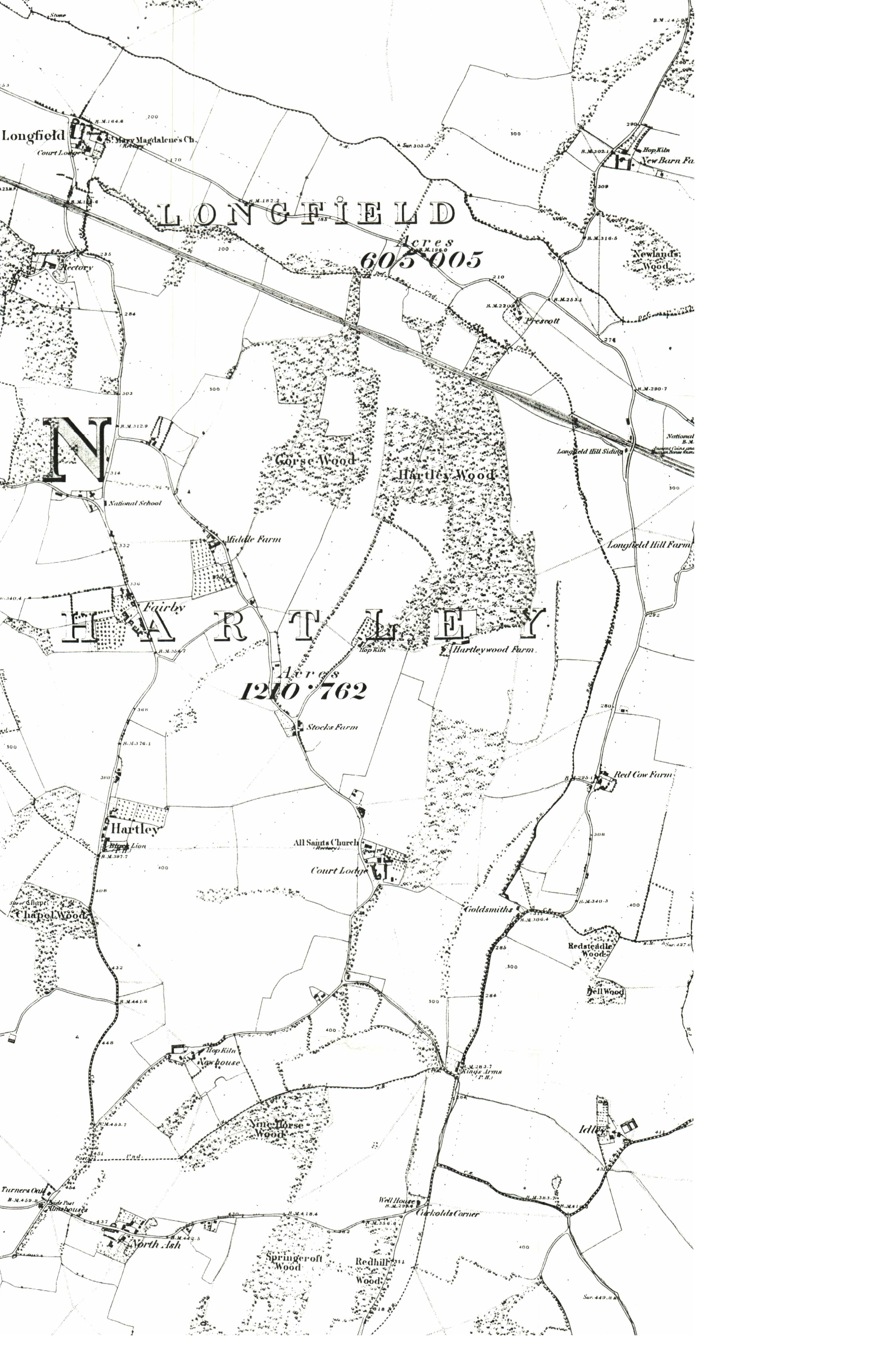
 and Brambledown (green) holdings 1925")
 and Brambledown (green) holdings 1946")


| Subject | Details |
| Length of Road: | Berrylands - 0.06 miles (100m) Manor Drive - n/a Manor Lane - 0.32 miles (508m) Manor View - 0.03 miles (56m) Springcroft - 0.21 miles (334m) |
| KCC Reference: | Berrylands - U12401 (adopted) Manor Drive - Restricted byway Manor Lane - U1120 (adopted) Manor View - U12207 (adopted) Springcroft - U12207 (adopted) |
| Acreage: | Berrylands - 1.25 acres (0.51 ha) Manor Drive - 40.19 acres (16.27 ha) Manor Lane - 5.29 acres (2.14 ha) Manor View - see Springcroft Springcroft - 12.6 acres (5.1 ha) |
| Houses/Flats | Berrylands - 9 Manor Drive - 47 Manor Lane - 3 Manor View - 5 Springcroft - 66 |
| Density: | Berrylands - 7.2 houses/acre (17.8 per ha) Manor Drive - 0.9 houses/acre (2.2 per ha) Manor Lane - 0.4 houses/acre (0.9 per ha) Manor View - see Springcroft Springcroft - 5.8 houses/acre (14.3 per ha) |
Population (2021): | Berrylands - 18 (2011 - 16) Manor Drive - 79 (2011 - 74) Manor Lane - 7 (2011 - 7) Manor View - 18 (2011 - 16 Springcroft - 158 (2011 - 164) |
Little Chimes Berrylands DA3 8AP
Detached bungalow
Former Name(s): Braken (to 1997)
Building History
1962 First Built
Rates and Council Tax
1972 Gross Rateable Value: £367
1993 Council Tax: F (£120-160K)
Sales and Rents
1997 Sale Price: £108000 (30 May 1997)
Site History
1392 Hartley Court - North Field
1844 Hartley Court - Lower North Field
Teal Berrylands DA3 8AP
Detached bungalow (2 bedroom)
Building History
1962 First Built
Rates and Council Tax
1963 Gross Rateable Value: £138
1972 Gross Rateable Value: £362
1993 Council Tax: F (£120-160K)
Sales and Rents
2002 Sale Price: £240000 (1 Jul 2002)
2015 Sale Price: £355000 (3 Sep 2015) Marketed £379,995 Annual percentage change since 2002: +3%
Site History
1392 Hartley Court - North Field
1844 Hartley Court - Lower North Field
Rowan Bank Berrylands DA3 8AP
Detached bungalow
Former Name(s): Allington (to 2006)
Building History
1962 First Built
Rates and Council Tax
1963 Gross Rateable Value: £138
1972 Gross Rateable Value: £362
1993 Council Tax: F (£120-160K)
Sales and Rents
2005 Sale Price: £295000 (22 Jul 2005)
Site History
1392 Hartley Court - North Field
1844 Hartley Court - Lower North Field
Neiderrhein Berrylands DA3 8AP
Detached bungalow
Former Name(s): Fairlawn (to 1967)
Building History
1962 First Built
Rates and Council Tax
1963 Gross Rateable Value: £133
1972 Gross Rateable Value: £362
1993 Council Tax: F (£120-160K)
Sales and Rents
Site History
1392 Hartley Court - North Field
1844 Hartley Court - Lower North Field
Fircroft Berrylands DA3 8AP
Detached bungalow
Building History
1962 First Built
Rates and Council Tax
1963 Gross Rateable Value: £133
1972 Gross Rateable Value: £337
1993 Council Tax: F (£120-160K)
Sales and Rents
Site History
1392 Hartley Court - North Field
1844 Hartley Court - Upper North Field
Alpine Berrylands DA3 8AP
Detached bungalow
Building History
1962 First Built
Rates and Council Tax
1963 Gross Rateable Value: £133
1972 Gross Rateable Value: £337
1993 Council Tax: F (£120-160K)
Sales and Rents
2004 Sale Price: £290000 (16 Jan 2004)
Site History
1392 Hartley Court - North Field
1844 Hartley Court - Upper North Field
Treeview Berrylands DA3 8AP
Detached bungalow (2 bedroom)
Building History
1962 First Built
2002 Planning Application: (GRANTED) 2002/1259 Single storey extensions to front and rear
2006 Planning Application: (GRANTED) 2006/2610 Replace conservatory with single storey extension
Rates and Council Tax
1963 Gross Rateable Value: £133
1963 Gross Rateable Value: £138
1972 Gross Rateable Value: £349
1993 Council Tax: E (£88-120K) Formerly Band F (1993)
Sales and Rents
2001 Sale Price: £215000 (21 Sep 2001)
2016 Sale Price: £565000 (20 Jan 2016) Annual percentage change since 2001: +7%
Site History
1392 Hartley Court - North Field
1844 Hartley Court - Upper North Field
Coppathorne Berrylands DA3 8AP
Detached bungalow (3 bedroom)
Building History
1985 First Built
Rates and Council Tax
1993 Council Tax: F (£120-160K)
Sales and Rents
1986 Sale Price: £93500 (30 Jul 1986)
2007 Sale Price: £365000 (8 May 2007) Annual percentage change since 1986: +7%
2007 Rental (per month): £1200.
2010 Rental (per month): £1200.
2017 Rental (per month): £1750.
Site History
1392 Hartley Court - North Field
1844 Hartley Court - Upper North Field
Trowley Bottom Berrylands DA3 8AP
Detached bungalow (4 bedroom, 101.8 sq m + garage 25.6 sq m + summerhouse 7.0 sq m)
Building History
1985 First Built
Rates and Council Tax
1993 Council Tax: F (£120-160K)
Sales and Rents
2001 Sale Price: £320000 (19 Sep 2001)
2022 Sale Price: £675000 (11 Mar 2022) Annual percentage change since 2001: +4%
Site History
1392 Hartley Court - North Field
1844 Hartley Court - Upper North Field
Maryfield Manor Drive DA3 8AN
Semi-detached house (6 bedroom)
Former Name(s): The Winnatts (to 1956)
Building History
1930 First Built
1968 Planning Application: (GRANTED) 1968/463 Extension to lounge, extension to provide double garage with bedroom over
1969 Planning Application: (GRANTED) 1969/199 Alterations and extensions
1983 Planning Application: (GRANTED) 1983/187 First Floor extenison
2006 Planning Application: (WITHDRAWN) 2006/2571 Convert to 6 bedroom convalescent home
2015 Planning Application: (GRANTED) 2015/785 Conversion of garage into kitchen/living accommodation. Alterations of front elevation and rear elevation fenestration.
2015 Planning Application: (GRANTED) 2015/1547 Conversion of the existing garage into living accommodation and change existing garage door opening to window and wall and alterations to rear elevation.
Rates and Council Tax
1956 Gross Rateable Value: £62
1963 Gross Rateable Value: £165
1972 Gross Rateable Value: £533
1993 Council Tax: G (£160-320K)
Sales and Rents
2007 Sale Price: £475000 (16 Apr 2007)
Site History
1392 Hartley Court - North Field
1844 Hartley Court - Upper North Field
Tallboys Manor Drive DA3 8AN
Semi-detached house (5 bedroom, 193.8 sq m + garage 36 sq m)
Former Name(s): Tichfield (to 1965)
Building History
1930 First Built
2006 Planning Application: (GRANTED) 2006/62 Single storey rear extension
2007 Planning Application: (REFUSED) 2007/2863 Erect house on land adjacent
2020 Planning Application: (REFUSED) 2020/1219 Demolition of existing garage and erection of new house.
Rates and Council Tax
1956 Gross Rateable Value: £55
1963 Gross Rateable Value: £160
1972 Gross Rateable Value: £409
1993 Council Tax: G (£160-320K) Formerly Band G (1993); then Band F (1993-2022)
Sales and Rents
2002 Sale Price: £396500 (27 Jun 2002)
2019 Sale Price: £800000 (12 Mar 2019) Advertised Price Annual percentage change since 1900: +4%
2021 Sale Price: £835000 (25 Jun 2021) Annual percentage change since 2002: +2%
Site History
1392 Hartley Court - North Field
1844 Hartley Court - Upper North Field
The Firs Manor Drive DA3 8AN
Detached House
Building History
1917 First Built
1939 Planning Application: (GRANTED) 1939/3105 Additional garage to plan 2953
1961 Planning Application: (GRANTED) 1961/22 Erect 7 detached bungalows and one pair of semi-detached bungalows
1975 Planning Application: (REFUSED) 1975/959 Outline planning for house adjoining
1975 Planning Application: (REFUSED) 1975/960 Outline planning to demolish and replace with 3 houses
1979 Planning Application: (GRANTED) 1979/848 EXTENSION TO SIDE OF DWELLING INCORPORATING DOUBLE GARAGE
1994 Planning Application: (GRANTED) 1994/1493 Side extension
1996 Planning Application: (GRANTED) 1996/152 Demolish and replace with 2 detached dwellings
Rates and Council Tax
1956 Gross Rateable Value: £60
1963 Gross Rateable Value: £190
1972 Gross Rateable Value: £454
1993 Council Tax: G (£160-320K)
Sales and Rents
1926 Sale Price: £1600 (1 May 1926) Advertised Price
Site History
1392 Hartley Court - North Field
1844 Hartley Court - Upper North Field
The Birches Manor Drive DA3 8AN
Detached House
Building History
1997 First Built
2009 Planning Application: (REFUSED) 2009/1043 New Crossover
Rates and Council Tax
1997 Council Tax: G (£160-320K)
Sales and Rents
Site History
1392 Hartley Court - North Field
1844 Hartley Court - Lower North Field
The Glen Manor Drive DA3 8AN
Detached House
Building History
1921 First Built
1962 Building demolished
1952 Planning Application: (GRANTED) 1952/49 additions & alterations
Rates and Council Tax
1956 Gross Rateable Value: £46
Sales and Rents
Site History
1392 Hartley Court - North Field
1844 Hartley Court - Lower North Field
Ashkeys Manor Drive DA3 8AN
Semi-detached house (4 bedroom, 173.9 sq m + garage 27.0 sq m)
Building History
1962 First Built
1967 Planning Application: (GRANTED) 1967/307 Enclosure of space between house and garage to form utility room
1987 Planning Application: (GRANTED) 1987/461 Porch
2002 Planning Application: (GRANTED) 2002/1046 1st floor side extension
Rates and Council Tax
1963 Gross Rateable Value: £140
1972 Gross Rateable Value: £390
1993 Council Tax: F (£120-160K)
Sales and Rents
2001 Sale Price: £275000 (14 Sep 2001)
2024 Sale Price: £685000 (16 Aug 2024) Annual percentage change since 2001: +4%
Site History
1392 Hartley Court - North Field
1844 Hartley Court - Lower North Field
Driftways Manor Drive DA3 8AN
Semi-detached house
Building History
1962 First Built
1998 Planning Application: (REFUSED) 1998/199 Detached dwelling on land adjoining
2002 Planning Application: (GRANTED) 2002/994 2 storey side extension
2003 Planning Application: (GRANTED) 2003/2095 Single storey rear extension
2007 Planning Application: (GRANTED) 2007/826 2 storey side extension
2024 Planning Application: (GRANTED) 2024/00247 Remove Ash tree (WTPO).
Rates and Council Tax
1963 Gross Rateable Value: £145
1972 Gross Rateable Value: £387
1993 Council Tax: E (£88-120K)
Sales and Rents
1999 Sale Price: £170000 (29 Oct 1999)
Site History
1392 Hartley Court - North Field
1844 Hartley Court - Lower North Field
Fairhaven Manor Drive DA3 8AN
Detached Chalet Bungalow (5 bedroom 187.4 sq m + Annexe 1 bedroom 76.7 sq m)
Former Name(s): Hartley Poultry Farm (to 1921)
Building History
1913 First Built
1949 Planning Application: (GRANTED) 1949/148 Addition of kitchen
1977 Planning Application: (GRANTED) 1977/715 Extension To Side And Rear Of Dwelling
1986 Planning Application: (GRANTED) 1986/1853 Garage
2006 Planning Application: (WITHDRAWN) 2006/452 Semi basement garage living room and bedroom over
2006 Planning Application: (GRANTED) 2006/453 Conservatory at rear
2006 Planning Application: (REFUSED) 2006/3325 2 storey side extension
2007 Planning Application: (GRANTED) 2007/2168 2 storey side annexe
2008 Planning Application: (GRANTED) 2008/310 Details (landscaping) v 07/2168
2008 Planning Application: (GRANTED) 2008/794 Details (landscaping) v 07/2168
Rates and Council Tax
1956 Gross Rateable Value: £44
1963 Gross Rateable Value: £120
1972 Gross Rateable Value: £594
1993 Council Tax: E (£88-120K) Formerly Band F (1993-2018). Plus Annexe (Band B - 2018)
Sales and Rents
1923 Sale Price: £2200 (7 Apr 1923) Advertised price, included site of future Springcroft
1950 Sale Price: £3100 (12 Jun 1950) Included land at back that became part of Springcroft Annual percentage change since 1923: +1%
2001 Sale Price: £311000 (18 Jul 2001) Annual percentage change since 1950: +9%
Site History
1392 Hartley Court - North Field
1844 Hartley Court - Lower North Field
The Pines Manor Drive DA3 8AN
Detached House (5 bedroom)
Building History
1972 First Built
1970 Planning Application: (GRANTED) 1970/564.1 Details of application 1970/564A
1978 Planning Application: (GRANTED) 1978/85 Alterations And Use Of Existing Garage For Additional Living Accommodation, Erection Of Attached Double Garage At Side Of Dwelling And Alteration To Vehicular Access
2009 Planning Application: (GRANTED) 2009/833 Single storey side extension. Alterations to remove flat roofs and provide pitched roofs to garage
2014 Planning Application: (GRANTED) 2014/3296 Erection of a first floor side extension.
Rates and Council Tax
1972 Gross Rateable Value: £425
1993 Council Tax: G (£160-320K) With improvement indicator (2025)
Sales and Rents
2007 Sale Price: £375000 (9 Nov 2007)
Site History
1392 Hartley Court - North Field
1844 Hartley Court - Lower North Field
Forge House Manor Drive DA3 8AN
Detached House (4 bedroom - 1972)
Building History
1972 First Built
1970 Planning Application: (GRANTED) 1970/564.1 Details of application 1970/564A
2006 Planning Application: (GRANTED) 2006/2656 Side conservatory
2007 Planning Application: (GRANTED) 2007/1006 Remodel porch
2012 Planning Application: (GRANTED) 2012/2951 erection of a two-storey side extension and single rear extension and the continuation of pitched roof from porch over to the garage on front fenestration.
2013 Planning Application: (N/A) 2013/1677 Alteration of playroom wall v 12/2951
2013 Planning Application: (GRANTED) 2013/2758 1st floor extension over existing extension
Rates and Council Tax
1972 Gross Rateable Value: £425
1993 Council Tax: G (£160-320K)
Sales and Rents
1972 Sale Price: £14750 (17 Aug 1972)
1973 Sale Price: £23950 (5 Jun 1973) Advertised price (SE Gazette) Annual percentage change since 1972: +83%
2003 Sale Price: £280000 (10 Jan 2003) Annual percentage change since 1973: +10%
Site History
1392 Hartley Court - North Field
1844 Hartley Court - Lower North Field
Brambledown Manor Drive DA3 8AN
Detached House
Building History
1924 First Built
1970 Building demolished
1931 Planning Application: (GRANTED) 1931/Meeting 1931-05-05 Conversion to bunglow
1970 Planning Application: (GRANTED) 1970/564 Demolish, replace with 3 detached dwellings
Rates and Council Tax
1956 Gross Rateable Value: £38
1963 Gross Rateable Value: £100
Sales and Rents
1933 Sale Price: £750 (31 Mar 1933)
Site History
1392 Hartley Court - North Field
1844 Hartley Court - Lower North Field
Chatenay Manor Drive DA3 8AN
Detached House
Building History
1918 First Built
1962 Planning Application: (GRANTED) 1962/443 Erect dwelling on land adjoining
1976 Planning Application: (REFUSED) 1976/446 Residential Development Of Approx 2.8 Hectares Land To Rear Of Chatenay Pwllycrochan And Patenga
1999 Planning Application: (GRANTED) 1999/2374 Erect 4 houses on land adjoining
2001 Planning Application: (GRANTED) 2001/140 Detached bungalow
2003 Planning Application: (GRANTED) 2003/820 Erect 2 houses at rear (details see 99.2374)
2003 Planning Application: (GRANTED) 2003/820 Erect 2 houses at rear (details see 99.2374), Details
2005 Planning Application: (GRANTED) 2005/1698 Amend previous approval for chalet bungalow
2006 Planning Application: (GRANTED) 2006/645 Chalet & triple garage (v 05/1698)
2006 Planning Application: (N/A) 2006/701 Details of balcony screens (v 05/1698)
2006 Planning Application: (N/A) 2006/1472 Erect detached double garage on land adjoining
Rates and Council Tax
1956 Gross Rateable Value: £35
1963 Gross Rateable Value: £105
1972 Gross Rateable Value: £251
1993 Council Tax: F (£120-160K)
Sales and Rents
Site History
1844 Stocks Farm - Four Acres
Hampton Cottage Manor Drive DA3 8AN
Detached Bungalow (4 bedroom)
Building History
2001 First Built
Rates and Council Tax
2001 Council Tax: F (£120-160K) Formerly Band G (1993-2001)
Sales and Rents
2006 Sale Price: £350000 (24 Jul 2006)
2013 Sale Price: £430000 (8 Aug 2013) Annual percentage change since 2006: +3%
Site History
1844 Stocks Farm - Four Acres
Orchard Cottage Manor Drive DA3 8AN
Detached House
Building History
2006 First Built
1999 Planning Application: (GRANTED) 1999/2374 Erection of three detached dwellings and garages.
2001 Planning Application: (GRANTED) 2001/140 Detached bungalow and garage,landscaping and external finishes.
2003 Planning Application: (GRANTED) 2003/1688 Details pursuant to condition 1 (landscaping) of SE/99/02374
2005 Planning Application: (GRANTED) 2005/1698 Retrospective application for construction of chalet bungalow and detached garage. (amendment to SE/03/00820)
2006 Planning Application: (GRANTED) 2006/645 Construction of a chalet bungalow and detached garage (revision to previous application SE/05/01698).
2006 Planning Application: (GRANTED) 2006/701 Details pursuant to condition 1 (balcony screens) of SE/05/01698
2006 Planning Application: (GRANTED) 2006/1474 Erection of a double garage (Revision to previously approved SE/06/00645/FUL).
2006 Planning Application: (GRANTED) 2006/2253 Details pursuant to condition 3 (landscaping) and condition 5 (hard surfacing) of planning permission SE/06/00645/FUL.
Rates and Council Tax
1993 Council Tax: G (£160-320K)
Sales and Rents
2006 Sale Price: £240000 (17 Jan 2006)
Site History
1844 Stocks Farm - Four Acres
Pwllycrechan Manor Drive DA3 8AN
Detached Chalet Bungalow (5 bedroom)
Building History
1922 First Built
1962 Planning Application: (REFUSED) 1962/378 Residential development at the back
1976 Planning Application: (REFUSED) 1976/446 Residential Development Of Approx 2.8 Hectares Land To Rear Of Chatenay Pwllycrochan And Patenga
1979 Planning Application: (REFUSED) 1979/1505 DEMOLITION OF EXISTING DWELLING AND ERECTION OF 3 DETACHED HOUSES WITH GARAGES
Rates and Council Tax
1956 Gross Rateable Value: £45
1963 Gross Rateable Value: £123
1972 Gross Rateable Value: £304
1996 Council Tax: G (£160-320K) Formerly Band F (1993-1996)
Sales and Rents
1997 Sale Price: £230000 (24 Jan 1997)
2008 Sale Price: £499995 (11 Jan 2008) Annual percentage change since 1997: +7%
Site History
1844 Stocks Farm - Four Acres
Forest House Manor Drive DA3 8AN
Detached Chalet Bungalow (5 bedroom)
Building History
1996 First Built
1997 Planning Application: (N/A) 1997/1753 2 storey side extension and rear swimming pool extension
1999 Planning Application: (GRANTED) 1999/971 2 storey extension to side and rear to include swimming pool
Rates and Council Tax
1996 Council Tax: G (£160-320K)
Sales and Rents
1996 Sale Price: £270000 (8 Nov 1996)
2014 Sale Price: £830000 (3 Oct 2014) Annual percentage change since 1996: +6%
Site History
1844 Stocks Farm - Four Acres
Baldhu Manor Drive DA3 8AN
Detached House
Detached Chalet Bungalow (4 bedroom 233.0 sq m including garage)
Former Name(s): Inglethorpe (to 1933); Patenga (1933-1962)
Building History
1924 First Built. Architect's plan by Gerald E Burgess in Kent Archives dated 1922 (CKS U2724/B3/353)
1922 Planning Application: (GRANTED) 1922/Meeting 1922-08-01 Bungalow
1924 Planning Application: (GRANTED) 1924/Meeting 1924-01-01 Brick Bungalow
1962 Planning Application: (GRANTED) 1962/308 Single storey extension to bungalow
1962 Planning Application: (GRANTED) 1962/471 Private garage
1966 Planning Application: (REFUSED) 1966/354 Outline - erect dwelling at rear
1976 Planning Application: (REFUSED) 1976/446 Residential Development Of Approx 2.8 Hectares Land To Rear Of Chatenay Pwllycrochan And Patenga
1979 Planning Application: (GRANTED) 1979/1009 EXTENSIONS TO REAR AND SIDE OF DWELLING
1983 Planning Application: (N/A) 1983/987 Replacement house
1984 Planning Application: (N/A) 1984/1455 Erect garage
2001 Planning Application: (GRANTED) 2001/193 Replacement garage, games room, conservatory
2005 Planning Application: (GRANTED) 2005/1428 Roof extension incorporating new dormers.
2006 Planning Application: (GRANTED) 2006/1821 Replacement garage
2009 Planning Application: (GRANTED) 2009/1323 Details pursuant to condition 2 (materials) of SE/06/01821/FUL
2016 Planning Application: (GRANTED) 2016/2228 Bathroom extension to front of the house.
Rates and Council Tax
1956 Gross Rateable Value: £38
1963 Gross Rateable Value: £102
1972 Gross Rateable Value: £389
2020 Council Tax: F (£120-160K) Formerly Band F (1993-2020)
Sales and Rents
2019 Sale Price: £800000 (22 May 2019)
Site History
1844 Stocks Farm - Four Acres
1844 Stocks Farm - Four Acres
Downlands Manor Drive DA3 8AN
Detached Chalet Bungalow (186 sq m + garage 30 sq m + summerhouse 10 sq m)
Building History
1985 First Built
1985 Planning Application: (GRANTED) 1985/1086 Erect house and bungalow at rear of Baldhu
2017 Planning Application: (N/A) 2017/3787 Erection of a single storey side/rear extensions incorporating the conversion of an existing garage.
Rates and Council Tax
1993 Council Tax: G (£160-320K) Plus Annexe (Band A - 2018). With improvement indicator (2025)
Sales and Rents
2003 Sale Price: £470000 (24 Jul 2003)
2006 Sale Price: £520000 (12 Oct 2006) Annual percentage change since 2003: +3%
2017 Sale Price: £885000 (1 Sep 2017) Annual percentage change since 2006: +5%
Site History
1844 Stocks Farm - Four Acres
Greycote Manor Drive DA3 8AT
Detached House
Building History
1921 First Built
1921 Planning Application: (GRANTED) 1921/Meeting 1921-09-13 Bungalow
1979 Planning Application: (REFUSED) 1979/478 ERECTION OF REPLACEMENT BUNGALOW AND GARAGE
1998 Planning Application: (GRANTED) 1998/2114 Stable block of 5, sand school, tack room
2000 Planning Application: (GRANTED) 2000/125 Details (demolition, manure disposal) v 98/2114
2002 Planning Application: (GRANTED) 2002/1335 Lighting of 25m x 40m sand school
Rates and Council Tax
1956 Gross Rateable Value: £52
1963 Gross Rateable Value: £140
1972 Gross Rateable Value: £344
Sales and Rents
Site History
1844 Hartley Wood Corner - Wood Field
Highfields Manor Drive DA3 8AT
Detached House
Building History
1915 First Built
2014 Demolished
2018 Rebuilt
1951 Planning Application: (REFUSED) 1951/2 Erect dwelling in connection with smallholding
1958 Planning Application: (GRANTED) 1958/2 Extension and alteration
1962 Planning Application: (REFUSED) 1962/143 Erect 2 prefab "Seco" buildings for poultry and rabbits
1968 Planning Application: (GRANTED) 1968/476 Extension to provide music room, kitchen with bedroom over
1973 Planning Application: (GRANTED) 1973/Meeting Jul 73 Extension
1974 Planning Application: (REFUSED) 1974/Meeting Jan 74 Erect detached house on land adjoining (OS 61506768)
1982 Planning Application: (GRANTED) 1982/1016 Extension to dwelling
1983 Planning Application: (GRANTED) 1983/469 Extension to dwelling
2003 Planning Application: (WITHDRAWN) 2003/1855 Replacement dwelling
2004 Planning Application: (GRANTED) 2004/1853 Replacement house
2009 Planning Application: (GRANTED) 2009/1767 Demolition of existing two storey dwelling house and associated outbuildings and the construction of new two storey dwelling house. (Renewal of Planning Permission Ref: SE/04/01853/FUL)
2010 Planning Application: (REFUSED) 2010/2432 Replacement 2 storey dwelling house
2012 Planning Application: (GRANTED) 2012/1488 Replacement house
2013 Planning Application: (REFUSED) 2013/2305 Amend condition 2, 6, 8 of 12/1488
2014 Planning Application: (GRANTED) 2014/574 Details (materials) v 12/1488
2014 Planning Application: (REFUSED) 2014/647 Details (landscaping) v 12/1488
2016 Planning Application: (GRANTED) 2016/3142 Details pursuant to condition 7ii (code for sustainable homes) of SE/12/01488/FUL.
2018 Planning Application: (REFUSED) 2018/2356 Erection of garage and storage building to be used for ancillary residential land maintenance
2018 Planning Application: (REFUSED) 2018/3875 Erection of garage and storage building to be used for ancillary residential land maintenance.
Rates and Council Tax
1956 Gross Rateable Value: £37
1963 Gross Rateable Value: £135
1972 Gross Rateable Value: £471
2005 Gross Rateable Value: £4100
2005 Gross Rateable Value: £4500
2018 Council Tax: H (over £320K) Previously Band G (1993-2014), plus annexe (Band A - 2002)
Sales and Rents
2001 Sale Price: £522000 (19 Sep 2001)
Site History
1633 Hartley Wood Farm - Six Acres
1844 Hartley Wood Farm - Six Acres
Highfields Cottage Manor Drive DA3 8AT
Detached House
Building History
1925 First Built
1925 Planning Application: (GRANTED) 1925/Meeting 1925-03-24 Garage & chaffeur's cottage
1958 Planning Application: (GRANTED) 1958/67 Extension
Rates and Council Tax
1956 Gross Rateable Value: £33
1963 Gross Rateable Value: £92
1972 Gross Rateable Value: £365
1993 Council Tax: G (£160-320K)
Sales and Rents
1998 Sale Price: £125000 (5 Oct 1998)
Site History
1633 Hartley Wood Farm - Six Acres
1844 Hartley Wood Farm - Six Acres
1963 Gross Rateable Value: £85
1972 Gross Rateable Value: £217
Highfields Cottage Annexe Manor Drive DA3 8AT
Detached House
Building History
1959 First Built
Rates and Council Tax
2002 Council Tax: A (£0-40K)
Sales and Rents
Site History
1633 Hartley Wood Farm - Six Acres
1844 Hartley Wood Farm - Six Acres
1 Hartley Wood Corner Manor Drive DA3 8AU
Semi-detached house
Building History
1642 First Built. Approximately
1987 Planning Application: (GRANTED) 1987/66 Amendment to extension
1987 Planning Application: (N/A) 1987/166 Raise extension to 2 storey
Rates and Council Tax
1956 Gross Rateable Value: £20
1963 Gross Rateable Value: £50
1972 Gross Rateable Value: £112
1993 Council Tax: F (£120-160K) Formerly Band G (1993)
Sales and Rents
Site History
1642 Hartley Wood Corner
1844 Hartley Wood Corner
2 Hartley Wood Corner Manor Drive DA3 8AU
Semi-detached house
Building History
1642 First Built
1800 Rebuilding
2014 Planning Application: (REFUSED) 2014/2643 Demolish house & barn, replace with 5 bed house
2015 Planning Application: (WITHDRAWN) 2015/1817 Demolition of existing single storey extensions and erection of 2 storey side and rear extensions, new drive and new dropped kerb.
2015 Planning Application: (REFUSED) 2015/3040 Convert barn into dwelling
2015 Planning Application: (GRANTED) 2015/3280 Demolition of existing single storey extensions, new two storey side and rear extension, new driveway and extension of existing dropped kerb
Rates and Council Tax
1956 Gross Rateable Value: £39
1963 Gross Rateable Value: £120
1972 Gross Rateable Value: £265
1993 Council Tax: F (£120-160K) With improvement indicator (2025)
Sales and Rents
2015 Sale Price: £412000 (6 May 2015)
Site History
1642 Hartley Wood Corner
1844 Hartley Wood Corner
2021 Planning Application: (WITHDRAWN) 2021/3550 Change of use and conversion of existing barn to provide 1no. dwelling with associated amenity space, parking and landscaping. Amended Consultation - Additional information as requested from comments by KCC Ecology
2025 Planning Application: (GRANTED) 2025/397 Details pursuant to condition 4 (location of electric charging point) of 23/03227/FUL.
2025 Planning Application: (GRANTED) 2025/459 Details pursuant to condition 12 (hard and soft landscaping) of 23/03227/FUL.
2025 Planning Application: (GRANTED) 2025/460 Details pursuant to condition 13 (boundary treatments) of 23/03227/FUL.
The Laurels Manor Drive DA3 8AU
Detached House
Former Name(s): Tara (to 2006)
Building History
1951 First Built
1947 Planning Application: (GRANTED) 1947/4225 Dwelling house
1968 Planning Application: (GRANTED) 1968/303 Extension to form garage, lounge, kitchen; new roof
1979 Planning Application: (GRANTED) 1979/150 Single storey and two storey extensions
1979 Planning Application: (GRANTED) 1979/1510 SINGLE STOREY AND TWO STOREY EXTENSIONS TO DWELLING
1979 Planning Application: (GRANTED) 1979/1510 Single storey side and rear extensions
1997 Planning Application: (GRANTED) 1997/1488 Demolish porch and garages, add new extension
1998 Planning Application: (GRANTED) 1998/562 Details (External finishes) v 97/1488
2005 Planning Application: (REFUSED) 2005/2982 Garage & workshop and pool house.
2006 Planning Application: (REFUSED) 2006/368 Proposed pool house and games room.
2006 Planning Application: (GRANTED) 2006/789 Pool house
2006 Planning Application: (GRANTED) 2006/1812 Alteration to roof
2006 Planning Application: (WITHDRAWN) 2006/2603 Conservatory
2006 Planning Application: (REFUSED) 2006/3188 Raise fence to 2.4m (retrospective)
2009 Planning Application: (GRANTED) 2009/2389 Erect orangery
2010 Planning Application: (GRANTED) 2010/115 Basement at rear of orangery
2011 Planning Application: (GRANTED) 2011/341 Erection of gym extension to existing outbuilding.
2012 Planning Application: (REFUSED) 2012/2923 Erection of first floor accommodation above garage, raising of the roof ridge, dormer windows to East and West elevations, ground floor extension to store room, erection of first floor corridor from garage to the main house
2014 Planning Application: (REFUSED) 2014/771 Single storey side extension, 2 storey rear extension, loft conversion with dormers to rear
2014 Planning Application: (GRANTED) 2014/1693 2 single storey flank extensions
2014 Planning Application: (REFUSED) 2014/3601 Lawful Development Certificate for erection of single storey double garage and car port
2014 Planning Application: (GRANTED) 2014/3601 Lawful Development Certificate for extension to existing driveway.
2014 Planning Application: (GRANTED) 2014/3602 Alterations to change the existing Garage into a Gymnasium.
2015 Planning Application: (GRANTED) 2015/210 Single Storey Garages and car port
2018 Planning Application: (GRANTED) 2018/3130 Repositioning of main entrance gates and driveway together with supporting brick walls.
2024 Planning Application: (GRANTED) 2024/01159 Works to various trees.
Rates and Council Tax
1956 Gross Rateable Value: £48
1963 Gross Rateable Value: £140
1972 Gross Rateable Value: £387
1993 Council Tax: F (£120-160K) Formerly Band G (1993), with improvement indicator (2025)
Sales and Rents
1997 Sale Price: £180000 (1 May 1997)
2023 Sale Price: £2300000 (30 Aug 2023) Annual percentage change since 1900: +10%
Site History
1392 Hartley Court - Hartley Wood
1844 Hartley Court - Hartley Wood
The Lodge Manor Drive DA3 8AU
Detached House
Building History
unknown First Built
2005 Planning Application: (WITHDRAWN) 2005/767 Single storey to rear and other alterations
2005 Planning Application: (GRANTED) 2005/2056 Extensions to the dwelling including, a single storey extension to rear, extending front bay, construction of a porch under existing veranda and construction of a garage and shed
2011 Planning Application: (GRANTED) 2011/1827 Extension of conservatory
2024 Planning Application: (REFUSED) 2024/00707 works to trees Notes: Objection Lodged
Rates and Council Tax
1956 Gross Rateable Value: £22
1963 Gross Rateable Value: £55
1972 Gross Rateable Value: £212
1993 Council Tax: F (£120-160K) With improvement indicator (2025)
Sales and Rents
1999 Sale Price: £179995 (18 Jun 1999)
Site History
1392 Hartley Court - Hartley Wood
1844 Hartley Court - Hartley Wood
Hartley Manor Manor Drive DA3 8AU
Detached House
Building History
1400 First Built. Approximately
1928 Planning Application: (GRANTED) 1928/Meeting 1928-02-07 Brick farm buildings
1931 Planning Application: (GRANTED) 1931/Meeting 1931-07-28 Addition of billiard room
1932 Planning Application: (GRANTED) 1932/Meeting 1932-12-06 Petrol pump and tank
1954 Planning Application: (GRANTED) 1954/27 Convert farm buildings into cottage (MR 617673)
1956 Planning Application: (REFUSED) 1956/356 Residential development
1975 Planning Application: (REFUSED) 1975/120 125 acre golf course
1999 Planning Application: (GRANTED) 1999/1272 Stables and tack room
1999 Planning Application: (GRANTED) 1999/2235 Details of disposal of manure pursuant to condition 3 of planning permission SE/99/1272.
2001 Planning Application: (GRANTED) 2001/1736 Conservatory
2008 Planning Application: (GRANTED) 2008/3407 Construct all weather menage
2009 Planning Application: (GRANTED) 2009/649 Details pursuant to condition 3 (riding surface sample) of SE/08/03407/FUL
2009 Planning Application: (GRANTED) 2009/651 Details pursuant to condition 5 (Tree Survey) of SE/08/03407/FUL
2009 Planning Application: (GRANTED) 2009/652 Details pursuant to condition 8 (Fencing) of SE/08/03407/FUL
Rates and Council Tax
1956 Gross Rateable Value: £170
1963 Gross Rateable Value: £425
1972 Gross Rateable Value: £1000
1993 Council Tax: H (£over 320K) With improvement indicator (2025)
Sales and Rents
1904 Sale Price: £500 (20 Jun 1904) Includes 140 acre farm estate
1904 Sale Price: £831.25 (21 Sep 1904) Includes 140 acre farm estate Annual percentage change since 1904: +635%
1976 Sale Price: £49500 (13 Mar 1976) Advertised price (Sevenoaks Chron) Annual percentage change since 1904: +6%
Site History
1400 Daltons
1844 Hartley Wood Farm
Larch Green Manor Drive DA3 8AW
Detached House
Building History
2007 First Built
1979 Planning Application: (NOT KNOWN) 1979/824 ERECTION OF ONE DETACHED BUNGALOW AND DOUBLE GARAGE
1979 Planning Application: (REFUSED) 1979/833 ERECTION OF ONE DETACHED HOUSE AND DOUBLE GARAGE
1979 Planning Application: (REFUSED) 1979/834 ERECTION OF ONE PAIR OF SEMI DETACHED DWELLINGS WITH GARAGES
1979 Planning Application: (NOT KNOWN) 1979/835 ERECTION OF ONE DETACHED HOUSE AND DOUBLE GARAGE
1979 Planning Application: (REFUSED) 1979/1909 ERECTION OF ONE DETACHED HOUSE AND GARAGE in garden of Greenways
1988 Planning Application: (GRANTED) 1988/916 Erection of a detached dwelling
2002 Planning Application: (GRANTED) 2002/1404 Erect new dwelling on land adjoining Greenways
2004 Planning Application: (GRANTED) 2004/1924 Widen existing vehicular access on land east of
2005 Planning Application: (REFUSED) 2005/801 Details pursuant to conditions 3 (materials), 5 (soft landscaping) and 8 (planting and levels) of SE/02/01404 and SE/04/01924 for a new detached dwellinghouse and detached double garage.
2006 Planning Application: (GRANTED) 2006/609 Details of soft landscaping and materials (v 02/1924)
Rates and Council Tax
2007 Council Tax: G (£160-320K)
Sales and Rents
2008 Sale Price: £500000 (19 Dec 2008)
Site History
1392 Hartley Court - North Field
1844 Hartley Court - Upper North Field
Greenways Manor Drive DA3 8AW
Semi-detached house
Building History
1921 First Built
1921 Planning Application: (GRANTED) 1921/Meeting 1921-07-19 2 houses
1977 Planning Application: (GRANTED) 1977/509 Extension To Side Of Dwelling
1979 Planning Application: (REFUSED) 1979/1909 ERECTION OF ONE DETACHED HOUSE AND GARAGE in garden of Greenways
2002 Planning Application: (GRANTED) 2002/1404 Erect new dwelling on land adjoining
2015 Planning Application: (REFUSED) 2015/1773 The erection of a new 2 bed detached dwelling within existing garden.
2016 Planning Application: (WITHDRAWN) 2016/833 The erection of a new 2 bed detached dwelling within existing garden.
2019 Planning Application: (GRANTED) 2019/881 Two storey side extension and single storey rear extension.
Rates and Council Tax
1956 Gross Rateable Value: £52
1963 Gross Rateable Value: £140
1972 Gross Rateable Value: £352
1993 Council Tax: F (£120-160K)
Sales and Rents
2016 Sale Price: £647500 (21 Dec 2016)
2023 Sale Price: £925000 (2 Jun 2023) Annual percentage change since 1900: +6%
Site History
1392 Hartley Court - North Field
1844 Hartley Court - Upper North Field
Cedars Manor Drive DA3 8AW
Semi-detached house
Former Name(s): Braeside (to 1939)
Building History
1921 First Built
1921 Planning Application: (GRANTED) 1921/Meeting 1921-07-19 2 houses
Rates and Council Tax
1956 Gross Rateable Value: £52
1963 Gross Rateable Value: £140
1972 Gross Rateable Value: £353
1993 Council Tax: E (£88-120K) Formerly Band F (1993); with improvement indicator (2025)
Sales and Rents
Site History
1392 Hartley Court - North Field
1844 Hartley Court - Upper North Field
Little Cedars Manor Drive DA3 8AW
Detached house (4 bed)
Building History
0 First Built
1964 Planning Application: (GRANTED) 1964/8 House adjoining Cedars
1964 Planning Application: (GRANTED) 1964/8 Detached bungalow and garage adjoining Cedars
1998 Planning Application: (GRANTED) 1998/378 Add 1st floor to bungalow
Rates and Council Tax
1993 Council Tax: F (£120-160K)
Sales and Rents
2011 Sale Price: £499000 (12 May 2011)
Site History
1392 Hartley Court - North Field
1844 Hartley Court - Upper North Field
St Margaret Manor Drive DA3 8AW
Detached House (4 bed - 1928)
Building History
0 First Built
1971 Planning Application: (GRANTED) 1971/234 Window at side, rear lounge, bedroom extension
1978 Planning Application: (GRANTED) 1978/424 DEMOLITION OF EXISTING AND ERECTION OF REPLACEMENT BUNGALOW WITH INTEGRAL GARAGE
1978 Planning Application: (GRANTED) 1978/424 Demolition Of Existing And Erection Of Replacement Bungalow With Integral Garage
2019 Planning Application: (REFUSED) 2019/1302 Conversion of bungalow to house, incorporating an infill at ground floor, first floor, balcony to rear elevation and detached garage.
2019 Planning Application: (GRANTED) 2019/2728 Conversion of bungalow to house, incorporating an infill at ground floor, first floor and balcony to rear elevation.
Rates and Council Tax
1956 Gross Rateable Value: £42
1963 Gross Rateable Value: £121
1972 Gross Rateable Value: £374
1993 Council Tax: G (£160-320K)
Sales and Rents
1928 Sale Price: £1300 (4 Apr 1928) Advertised price
2003 Sale Price: £500000 (8 Jul 2003) Annual percentage change since 1928: +8%
2021 Sale Price: £1026000 (26 Oct 2021) Planning Permissions since previous sale Annual percentage change since 2003: +4%
Site History
1392 Hartley Court - North Field
1844 Hartley Court - Lower North Field
The Briars Manor Drive DA3 8AW
Detached House (5 bedrooms) 1973 - 3 bedrooms
Building History
0 First Built
1975 Planning Application: (REFUSED) 1975/368 Demolish garage, erect 2 storey living room, bedroom, bathroom with garage underneath
1981 Planning Application: (REFUSED) 1981/1714 2 storey extension and porch
1982 Planning Application: (GRANTED) 1982/408 2 storey extension and porch
2006 Planning Application: (REFUSED) 2006/2540 New detached house to rear
2014 Planning Application: (INVALIDATED) 2014/135 Replacement garage
2016 Planning Application: (GRANTED) 2016/2767 Details pursuant to condition 3 (material samples) of planning permission 14/00135/HOUSE
2016 Planning Application: (REFUSED) 2016/2828 Details pursuant to condition 4 (driveway and access arrangements) of planning permission 14/00135/HOUSE
2016 Planning Application: (GRANTED) 2016/2829 Details pursuant to condition 6 (soft landscaping) of planning permission 14/00135/HOUSE.
Rates and Council Tax
1956 Gross Rateable Value: £45
1963 Gross Rateable Value: £130
1972 Gross Rateable Value: £327
1993 Council Tax: G (£160-320K)
Sales and Rents
1973 Sale Price: £27500 (2 Mar 1973) Advertised price
1997 Sale Price: £228500 (31 Oct 1997) Annual percentage change since 1973: +9%
2012 Sale Price: £575000 (11 May 2012) Annual percentage change since 1997: +7%
Site History
1392 Hartley Court - North Field
1844 Hartley Court - Lower North Field
Primrose Cottage Manor Drive DA3 8AW
Detached house (4 bed)
Former Name(s): Kirkee (to 1983)
Building History
1921 First Built
1984 Planning Application: (GRANTED) 1984/483 Extension
1986 Planning Application: (GRANTED) 1986/1109
2017 Planning Application: (N/A) 2017/3681 Single storey extension, realignment to retaining wall on NW elevation. Changes to fenestration
Rates and Council Tax
1956 Gross Rateable Value: £55
1963 Gross Rateable Value: £145
1972 Gross Rateable Value: £317
1993 Council Tax: G (£160-320K)
Sales and Rents
1950 Sale Price: £1500 (4 Oct 1950) Surveyor's valuation
2004 Sale Price: £520000 (23 Apr 2004) Annual percentage change since 1950: +12%
2010 Sale Price: £625000 (23 Aug 2010) Annual percentage change since 2004: +3%
2016 Sale Price: £735500 (26 Jul 2016) Annual percentage change since 2010: +3%
Site History
1392 Hartley Court - North Field
1844 Hartley Court - Lower North Field
Sanctamaria Manor Drive DA3 8AW
Detached House (5 bed)
Building History
1925 First Built
1975 Rebuilding
1925 Planning Application: (GRANTED) 1925/Meeting 1925-02-24 Concrete bungalow
1973 Planning Application: (NOT KNOWN) 1973/Meeting Jun 73 (Gloria) demolish and rebuild existing house
1974 Planning Application: (REFUSED) 1974/70 THE DEMOLITION OF EXISTING BUNGALOW AND ERECTION OF A DETACHED DWELLING HOUSE AND GARAGE
1975 Planning Application: (GRANTED) 1975/169 Demolish (Gloria) erect new bungalow with double garage at rear
2022 Planning Application: (WITHDRAWN) 2022/2931 Extend and subdivide existing dwelling into two separate dwellings and erection of 2 additional dwellings to the rear, with associated landscaping.
Rates and Council Tax
1956 Gross Rateable Value: £41
1963 Gross Rateable Value: £110
1972 Gross Rateable Value: £259
1993 Council Tax: G (£160-320K)
Sales and Rents
2012 Sale Price: £500000 (20 Dec 2012)
2013 Sale Price: £650000 (28 Oct 2013) Annual percentage change since 2012: +36%
Site History
1392 Hartley Court - North Field
1844 Hartley Court - Lower North Field
Cheslyne Manor Drive DA3 8AW
Detached House (5 bed)
Former Name(s): St Joan (to 1972); Foysden (1972-1979)
Building History
1927 First Built
1966 Planning Application: (GRANTED) 1966/115 4 Stall stable for family use
1967 Planning Application: (GRANTED) 1967/59 Extensions and alterations at front
1967 Planning Application: (REFUSED) 1967/60 Covered area for storage of hay
1967 Planning Application: (GRANTED) 1967/257 Double Garage
1968 Planning Application: (GRANTED) 1968/474 Front porch
2003 Planning Application: (GRANTED) 2003/1751 Demolish porch, single storey front extension
2005 Planning Application: (REFUSED) 2005/823 Boundary Wall and railing at front
Rates and Council Tax
1956 Gross Rateable Value: £43
1963 Gross Rateable Value: £118
1972 Gross Rateable Value: £515
1993 Council Tax: G (£160-320K)
Sales and Rents
2001 Sale Price: £299500 (7 Dec 2001)
2003 Sale Price: £370000 (11 Jul 2003) Annual percentage change since 2001: +14%
2014 Sale Price: £975000 (14 May 2014) Annual percentage change since 2003: +9%
2022 Sale Price: £1155000 (27 Jan 2022) Annual percentage change since 2014: +2%
Site History
1392 Hartley Court - North Field
1844 Hartley Court - Lower North Field
Lilison Manor Drive DA3 8AW
Detached House
Former Name(s): Penolive (to 1967)
Building History
1939 First Built
1939 Planning Application: (GRANTED) 1939/2976 Detached bungalow
Rates and Council Tax
1956 Gross Rateable Value: £38
1963 Gross Rateable Value: £105
1972 Gross Rateable Value: £251
1993 Council Tax: F (£120-160K)
Sales and Rents
2021 Sale Price: £825000 (12 Aug 2021)
2024 Sale Price: £865000 (25 Jul 2024) Annual percentage change since 2021: +2%
Site History
1392 Hartley Court - North Field
1844 Hartley Court - Lower North Field
Edelweiss Manor Drive DA3 8AW
Detached House
Building History
1970 First Built
1962 Planning Application: (REFUSED) 1962/233 Residential development on site of
1965 Planning Application: (GRANTED) 1965/151 Residential Development on land adjoining
1965 Planning Application: (GRANTED) 1965/151.1 6 detached houses on land adjoining Southdown
Rates and Council Tax
1972 Gross Rateable Value: £349
1993 Council Tax: F (£120-160K)
Sales and Rents
Site History
1844 Stocks Farm - Four Acres
Tall Trees Manor Drive DA3 8AW
Detached House
Building History
1970 First Built
1962 Planning Application: (REFUSED) 1962/233 Residential development on site of
1965 Planning Application: (GRANTED) 1965/151 Residential Development on land adjoining
1965 Planning Application: (GRANTED) 1965/151.1 6 detached houses on land adjoining Southdown
1979 Planning Application: (GRANTED) 1979/1236 EXTENSIONS TO FRONT AND SIDE OF DWELLING AND FRONT OF EXISTING GARAGE
2008 Planning Application: (GRANTED) 2008/2087 Conservatory
Rates and Council Tax
1972 Gross Rateable Value: £349
1993 Council Tax: G (£160-320K)
Sales and Rents
2005 Sale Price: £380000 (25 Aug 2005)
Site History
1844 Stocks Farm - Four Acres
Studley Dene Manor Drive DA3 8AW
Detached House
Building History
1970 First Built
1962 Planning Application: (REFUSED) 1962/233 Residential development on site of
1965 Planning Application: (GRANTED) 1965/151 Residential Development on land adjoining
1965 Planning Application: (GRANTED) 1965/151.1 6 detached houses on land adjoining Southdown
1975 Planning Application: (GRANTED) 1975/251 single storey dining room, kitchen & utility room extension at rear
1979 Planning Application: (GRANTED) 1979/510 EXTENSION TO FRONT OF GARAGE AT SIDE OF DWELLING, FIRST FLOOR EXTENSION OVER EXISTING GARAGE AND PORCH AT FRONT
Rates and Council Tax
1972 Gross Rateable Value: £349
1993 Council Tax: G (£160-320K)
Sales and Rents
Site History
1844 Stocks Farm - Four Acres
Entwood Manor Drive DA3 8AW
Detached House
Building History
1970 First Built
1962 Planning Application: (REFUSED) 1962/233 Residential development on site of
1965 Planning Application: (GRANTED) 1965/151 Residential Development on land adjoining
1965 Planning Application: (GRANTED) 1965/151.1 6 detached houses on land adjoining Southdown
1977 Planning Application: (GRANTED) 1977/1010 Extension To Rear Of Dwelling
Rates and Council Tax
1972 Gross Rateable Value: £349
1993 Council Tax: G (£160-320K)
Sales and Rents
Site History
1844 Stocks Farm - Four Acres
Hideaway Manor Drive DA3 8AW
Detached House
Building History
1970 First Built
1962 Planning Application: (REFUSED) 1962/233 Residential development on site of
1970 Planning Application: (GRANTED) 1970/105 extension over garage
2003 Planning Application: (GRANTED) 2003/2233 Single storey extension, detached garage
2004 Planning Application: (GRANTED) 2004/718 Detached garage
2004 Planning Application: (GRANTED) 2004/718 Details pursuant to condition 2 of SE/03/02233- external materials
2004 Planning Application: (GRANTED) 2004/718 Details pursuant to condition 3 (materials) of consent SE/04/00718/FUL.
Rates and Council Tax
1972 Gross Rateable Value: £399
1993 Council Tax: G (£160-320K)
Sales and Rents
2003 Sale Price: £299550 (17 Feb 2003)
2017 Sale Price: £680000 (21 Jul 2017) Annual percentage change since 2003: +6%
Site History
1844 Stocks Farm - Four Acres
Hillside Manor Drive DA3 8AW
Detached House
Building History
1970 First Built
1962 Planning Application: (REFUSED) 1962/233 Residential development on site of
1965 Planning Application: (GRANTED) 1965/151 Residential Development on land adjoining
1965 Planning Application: (GRANTED) 1965/151.1 6 detached houses on land adjoining Southdown
1971 Planning Application: (GRANTED) 1971/170 Car port at side
1984 Planning Application: (GRANTED) 1984/615 Extension
2006 Planning Application: (GRANTED) 2006/1691 Side, rear & front extensions
2015 Planning Application: (GRANTED) 2015/3506 Extention to the front porch
Rates and Council Tax
1972 Gross Rateable Value: £269
1993 Council Tax: F (£120-160K) Formerly Band F (1993)
Sales and Rents
2006 Sale Price: £372000 (7 Jul 2006)
2017 Sale Price: £679000 (8 Dec 2017) Annual percentage change since 2006: +5%
Site History
1844 Stocks Farm - Four Acres
Southdown Manor Drive DA3 8AW
Detached House
Former Name(s): Tyn-y-Gerddi (to 1960)
Building History
1923 First Built
2006 Demolished
1964 Planning Application: (REFUSED) 1964/128 Residential development at Manor Drive
1965 Planning Application: (GRANTED) 1965/151 Residential Development on land adjoining
2004 Planning Application: (REFUSED) 2004/859 Demolish, replace with 3 houses
2005 Planning Application: (GRANTED) 2005/1315 Demolish, replace with 3 houses
2006 Planning Application: (GRANTED) 2006/175 Details pursuant to conditions 8 (soft landscaping) and 12 (protection of trees) of SE/05/1315/FUL
2006 Planning Application: (GRANTED) 2006/175 Details of materials pursuant to condition 2 of planning permission SE/05/01315/FUL
2006 Planning Application: (GRANTED) 2006/820 Details pursuant to permission 05/1315
2007 Planning Application: (GRANTED) 2007/3030 Vary condition on windows
2008 Planning Application: (GRANTED) 2008/2116 New driveways to plots 2 and 3
Rates and Council Tax
1956 Gross Rateable Value: £44
1963 Gross Rateable Value: £120
1972 Gross Rateable Value: £279
1993 Council Tax: F (£120-160K) Removed from list 2006
Sales and Rents
Site History
1844 Stocks Farm - Four Acres
1 Southdown Manor Drive DA3 8AW
Detached House
Building History
2007 First Built
Rates and Council Tax
2007 Council Tax: G (£160-320K)
Sales and Rents
2009 Sale Price: £492500 (3 Apr 2009)
2010 Sale Price: £540000 (20 Dec 2010) Annual percentage change since 2009: +6%
Site History
1844 Stocks Farm - Four Acres
Cherry Tree House Manor Drive DA3 8AW
Detached House (5 bed)
Former Name(s): 2 Southdown (to 2007)
Building History
2007 First Built
Rates and Council Tax
2008 Gross Rateable Value: £13000
2009 Gross Rateable Value: £Deleted
2007 Council Tax: G (£160-320K)
Sales and Rents
2009 Sale Price: £485000 (5 Jun 2009)
2014 Sale Price: £700000 (17 Jul 2014) Annual percentage change since 2009: +7%
Site History
1844 Stocks Farm - Four Acres
3 Southdown Manor Drive DA3 8AW
Detached House
Building History
2007 First Built
Rates and Council Tax
2007 Council Tax: G (£160-320K)
Sales and Rents
2009 Sale Price: £485000 (2 Dec 2009)
Site History
1844 Stocks Farm - Four Acres
Aldingham Manor Drive DA3 8AU
Detached House (4/5 bedroom, 336 sq m + garage 64 sq m, outbuildings 27 sq m, roof terrace 24 sq m)
Former Name(s): June Hill (to 1956)
Building History
1918 First Built
1948 Planning Application: (GRANTED) 1948/186 development of land for house
1949 Planning Application: (GRANTED) 1949/147 Erect detached house
1962 Planning Application: (GRANTED) 1962/27 Addition of bathroom, bedroom and study
1976 Planning Application: (REFUSED) 1976/1331 Erection Of One Detached Dwelling And Garage And Construction Of Cesspool Adjoining June Hill
1978 Planning Application: (GRANTED) 1978/1529 Extensions To Side And Rear Of Dwelling
2000 Planning Application: (GRANTED) 2000/335 Conversion of property back to single dwelling
Rates and Council Tax
1963 Gross Rateable Value: £285
1993 Council Tax: G (£160-320K)
Sales and Rents
1924 Sale Price: £2000 (23 Feb 1924) Advertised price
1970 Sale Price: £17950 (20 Feb 1970) Annual percentage change since 1924: +5%
2000 Sale Price: £499000 (31 Jan 2000) Annual percentage change since 1970: +8%
2024 Sale Price: £1799950 (25 Jun 2024) Advertised price Annual percentage change since 2000: +9%
Site History
1844 Hartley Wood Farm - Homefield
June Hill Manor Drive DA3 8AU
Detached House
Building History
1957 First Built
Rates and Council Tax
1956 Gross Rateable Value: £65
1963 Gross Rateable Value: £195
1972 Gross Rateable Value: £516
1993 Council Tax: G (£160-320K)
Sales and Rents
Site History
1633 Daltons - Upper Horse Lease
1844 Hartley Wood Farm - Homefield
Long Acres Manor Drive DA3 8AU
Detached House
Building History
0 First Built
1961 Planning Application: (REFUSED) 1961/231 Residential development
1978 Planning Application: (GRANTED) 1978/418 Alterations And Use Of Existing Garage For Domestic Playroom
1978 Planning Application: (REFUSED) 1978/418 Alterations and use of single garage as playroom
1980 Planning Application: (GRANTED) 1980/122 Erection of Porch
1980 Planning Application: (GRANTED) 1980/434 Extension to shed/storage building
1981 Planning Application: (GRANTED) 1981/796 Erect detached sun house
1982 Planning Application: (GRANTED) 1982/1152 Extension to dwelling
1982 Planning Application: (GRANTED) 1982/1196 Triple domestic garage attached to store building
1993 Planning Application: (REFUSED) 1993/176 Front boundary wall 1.83m high and 3m wide gates
1998 Planning Application: (REFUSED) 1998/601 Erect detached house on land adjoining
2016 Planning Application: (REFUSED) 2016/1308 Erection of a single storey extension.
2017 Planning Application: (REFUSED) 2017/80 Erection of a single storey extension to existing detached bungalow.
Rates and Council Tax
1956 Gross Rateable Value: £40
1963 Gross Rateable Value: £115
1972 Gross Rateable Value: £571
1993 Council Tax: G (£160-320K)
Sales and Rents
1977 Sale Price: £59000 (14 May 1977) Advertised price (Sevenoaks Chron)
Site History
1633 Daltons - Upper Horse Lease
1844 Hartley Wood Farm - Homefield
Ingomar Manor Drive DA3 8AU
Detached House
Building History
0 First Built
Rates and Council Tax
1956 Gross Rateable Value: £22
1963 Gross Rateable Value: £66
1972 Gross Rateable Value: £173
1993 Council Tax: B (£40-52K)
Sales and Rents
Site History
1633 Daltons - Upper Horse Lease
1844 Hartley Wood Farm - Homefield
The Owenabue Manor Lane DA3 8AX
Detached House (5 bed)
Former Name(s): Nairobi (to 1969); Orchard House (1969-2012)
Building History
1918 First Built
2012 Rebuilding
1962 Planning Application: (REFUSED) 1962/183 Erect 2 detached dwellings adjoining Nairobi
1977 Planning Application: (GRANTED) 1977/5 Two Storey Extension To Rear Of Dwelling
2008 Planning Application: (WITHDRAWN) 2008/1229 Demolish, replace with 2 storey house and garage
2008 Planning Application: (GRANTED) 2008/2824 Replacement house
2010 Planning Application: (GRANTED) 2010/2047 Replacement 2 storey house (amendment to 08/2824)
2010 Planning Application: (GRANTED) 2010/3440 Details (materials) v 10/2047
2010 Planning Application: (GRANTED) 2010/3441 Details (levels, slab levels) v 10/2047)
2010 Planning Application: (REFUSED) 2010/3442 Details (soft landscaping) v 10/2047
2010 Planning Application: (GRANTED) 2010/3443 Details (hard landscaping) v 10/2047
2010 Planning Application: (REFUSED) 2010/3444 Details (enclosure) v 10/2047
2010 Planning Application: (N/A) 2010/3445 Details (bat survey, mitigation survey) v 10/2047
2011 Planning Application: (GRANTED) 2011/1262 Details (soft landscaping) v 10/02047
2011 Planning Application: (GRANTED) 2011/2291 Replacement games room
2011 Planning Application: (GRANTED) 2011/2991 Replacement timber framed games room
2012 Planning Application: (N/A) 2012/2853 Details pursuant to condition 2 (materials) v 11/02291
2013 Planning Application: (GRANTED) 2013/342 Details (means of enclosure) v 10/2047
2013 Planning Application: (GRANTED) 2013/691 Details (materials) v 11/2291
2020 Planning Application: (REFUSED) 2020/1730 Erection of single storey extension to rear of existing detached garage
2020 Planning Application: (GRANTED) 2020/3381 Erection of single storey outbuilding to facilitate a pool room and gym.
Rates and Council Tax
1956 Gross Rateable Value: £45
1963 Gross Rateable Value: £125
1972 Gross Rateable Value: £330
1993 Council Tax: G (£160-320K)
Sales and Rents
1969 Sale Price: £9500 (31 Jan 1969)
2006 Sale Price: £675000 (21 Nov 2006) Annual percentage change since 1969: +12%
Site History
1844 Stocks Farm - Barn Field
Fairfields Manor Lane DA3 8AX
Detached House (5 bed) + Annexe (2021)
Building History
1951 First Built
1963 Planning Application: (REFUSED) 1963/647 Residential development
2024 Planning Application: (DECIDED) 2024/01153 Prior notification of two rear extensions which extends 7.60m & 7.60m beyond the rear wall of the original dwelling house with a maximum height of 3.96m & 3.96m and eaves height of 3.00m & 3.00m.
2024 Planning Application: (GRANTED) 2024/1730 Two single storey extensions to main house: one rear extension with roof lights, and one side and rear extension with roof lights.
Rates and Council Tax
1956 Gross Rateable Value: £60
1963 Gross Rateable Value: £170
1972 Gross Rateable Value: £385
1993 Council Tax: G (£160-320K) Plus Annexe (Band B - 2021)
Sales and Rents
1996 Sale Price: £330000 (30 Aug 1996)
2011 Sale Price: £815000 (5 Aug 2011) Annual percentage change since 1996: +6%
2022 Sale Price: £1500000 (27 Sep 2022) Annual percentage change since 2011: +6%
Site History
1844 Stocks Farm - Barn Field
Luxor Manor Lane DA3 8AX
Detached bungalow (2 bedroom, 87 sq m)
Former Name(s): Fairfield Lodge (2022)
Building History
2022 Converted from garage/store built in 2012
2021 Planning Application: (GRANTED) 2021/2089 Conversion of existing garage/workshop to a single dwelling house including garden amenity space, access and associated landscaping (Fairfields)
2021 Planning Application: (GRANTED) 2021/3184 Minor material amendment to 21/02089/FUL.
2022 Planning Application: (GRANTED) 2022/2623 Details pursuant to condition 4 (landscaping) subject to 21/02089/FUL
2022 Planning Application: (GRANTED) 2022/2722 Details pursuant to condition 6 (biodiversity) subject to 21/02089/FUL
2022 Planning Application: (GRANTED) 2022/2723 Details pursuant to condition 7 (lighting) subject to 21/02089/FUL
Rates and Council Tax
2022 Council Tax: F (£120-160K)
Sales and Rents
Site History
1844 Stocks Farm - Barn Field
1 Manor View DA3 8BA
Detached Chalet Bungalow (4 bedroom, 146.2 sq m + integral garage 12 sq m)
Building History
1970 First Built
1991 Planning Application: (GRANTED) 1991/705 Lean to pitched roof to existing dormers
1996 Planning Application: (GRANTED) 1996/1350 Porch utility room and garden room ground floor extension
2016 Planning Application: (REFUSED) 2016/1058 Extension to loft.
Rates and Council Tax
1972 Gross Rateable Value: £389
1993 Council Tax: F (£120-160K)
Sales and Rents
2004 Sale Price: £355000 (28 Jan 2004)
2025 Sale Price: £495000 (8 May 2025) Auction Guide Price. Previously marketed 14/8/23 - £850,000; 26/6/24 - £660,000 Annual percentage change since 2004: +2%
Site History
1392 Hartley Court - North Field
1844 Hartley Court - Lower North Field
2 Manor View DA3 8BA
Detached chalet bungalow (3 bedroom)
Building History
1969 First Built
1970 Planning Application: (GRANTED) 1970/564.1 Details of application 1970/564A
Rates and Council Tax
1972 Gross Rateable Value: £389
1993 Council Tax: F (£120-160K)
Sales and Rents
2005 Sale Price: £302000 (25 Jul 2005)
2009 Sale Price: £285000 (30 Jun 2009) Annual percentage change since 2005: -1%
Site History
1392 Hartley Court - North Field
1844 Hartley Court - Lower North Field
3 Manor View DA3 8BA
Detached house (3 bed)
Building History
1970 First Built
Rates and Council Tax
1972 Gross Rateable Value: £389
1993 Council Tax: F (£120-160K)
Sales and Rents
1974 Sale Price: £20000 (19 Nov 1974) Advertised price (SE Gazette)
Site History
1392 Hartley Court - North Field
1844 Hartley Court - Lower North Field
4 Manor View DA3 8BA
Detached Chalet Bungalow (4 bedroom, 146 sq m + outbuilding 14 sq m)
Building History
1970 First Built
2003 Planning Application: (REFUSED) 2003/1264 Convert garage into room, add 2 storey extension
2003 Planning Application: (REFUSED) 2003/2164 Convert garage to room, 2 storey extension with integral garage
2007 Planning Application: (GRANTED) 2007/1075 Single storey and dormer extensions
2010 Planning Application: (GRANTED) 2010/749 Details pursuant to condition 3 materials (in part)v 07/01075
2022 Planning Application: (GRANTED) 2022/2208 Use of the land for siting a mobile home for use ancillary to the main dwelling
Rates and Council Tax
1972 Gross Rateable Value: £389
1993 Council Tax: F (£120-160K)
Sales and Rents
2002 Sale Price: £215000 (23 May 2002)
2014 Sale Price: £385000 (17 Oct 2014) Planning permissions since previous sale Annual percentage change since 2002: +5%
2022 Sale Price: £675000 (24 Jun 2022) Annual percentage change since 2014: +8%
Site History
1392 Hartley Court - North Field
1844 Hartley Court - Lower North Field
5 Manor View DA3 8BA
Detached House
Building History
1970 First Built
Rates and Council Tax
1993 Council Tax: F (£120-160K)
Sales and Rents
1999 Sale Price: £166000 (10 Sep 1999)
Site History
1392 Hartley Court - North Field
1844 Hartley Court - Lower North Field
Semi-detached bungalow
Building History
1957 First Built
2006 Planning Application: (GRANTED) 2006/2069 The formation of two new bedrooms at first floor level, extension of existing garage, new cross over and hard standing and new wall to the existing courtyard.
2006 Planning Application: (GRANTED) 2006/2609 Extend garage, new crossover, formation of 2 new bedrooms
2007 Planning Application: (GRANTED) 2007/381 Revision of 06/2069
Rates and Council Tax
1963 Gross Rateable Value: £113
1972 Gross Rateable Value: £308
1993 Council Tax: E (£88-120K) With improvement indicator (2025)
Sales and Rents
Site History
1392 Hartley Court - North Field
1844 Hartley Court - Lower North Field
3 Springcroft DA3 8AR
Semi-detached bungalow (2 bedroom)
Building History
1957 First Built
1975 Planning Application: (GRANTED) 1975/489 Car port at side
Rates and Council Tax
1963 Gross Rateable Value: £113
1972 Gross Rateable Value: £287
2013 Council Tax: D (£68-88K) Formerly Band D (1993-2013)
Sales and Rents
1995 Sale Price: £88000 (8 Dec 1995)
2014 Sale Price: £267500 (26 Feb 2014) Annual percentage change since 1995: +6%
Site History
1392 Hartley Court - North Field
1844 Hartley Court - Lower North Field
5 Springcroft DA3 8AR
Semi-detached house (1974 semi-detached bungalow, 2 bedrooms)
Building History
1957 First Built
1975 Planning Application: (GRANTED) 1975/462 Car port at side
1998 Planning Application: (GRANTED) 1998/301 Kitchen and dormer extension
2006 Planning Application: (GRANTED) 2006/3010 Vertical extension of loft voids
Rates and Council Tax
1963 Gross Rateable Value: £113
1972 Gross Rateable Value: £287
1993 Council Tax: E (£88-120K) Formerly Band F (1993); plus Annexe (Band A from 2023)
Sales and Rents
1974 Sale Price: £13250 (5 Apr 1974)
1997 Sale Price: £111000 (29 Aug 1997) Annual percentage change since 1974: +10%
Site History
1392 Hartley Court - North Field
1844 Hartley Court - Lower North Field
7 Springcroft DA3 8AR
Semi-detached house (5 bedroom, 192.9 sq m + gym/office 31 sq m)
Building History
1957 First Built
1956 Planning Application: (GRANTED) 1956/98 Private garage
2005 Planning Application: (GRANTED) 2005/2976 Side and rear extension
2006 Planning Application: (GRANTED) 2006/3010 Vertical extension of loft voids
2016 Planning Application: (GRANTED) 2016/3162 Replacement of an existing detached garage with a new single storey flank/rear extension and part 2 storey extension to the rear of the property.
Rates and Council Tax
1963 Gross Rateable Value: £113
1972 Gross Rateable Value: £287
1993 Council Tax: E (£88-120K)
Sales and Rents
2005 Sale Price: £220000 (18 Nov 2005)
2023 Sale Price: £710000 (8 Nov 2023) Annual percentage change since 2005: +7%
Site History
1392 Hartley Court - North Field
1844 Hartley Court - Lower North Field
9 Springcroft DA3 8AR
Semi-detached bungalow
Building History
2000 First Built
Rates and Council Tax
1963 Gross Rateable Value: £100
1972 Gross Rateable Value: £300
1993 Council Tax: E (£88-120K)
Sales and Rents
2003 Sale Price: £230000 (13 May 2003)
Site History
1392 Hartley Court - North Field
1844 Hartley Court - Lower North Field
11 Springcroft DA3 8AR
Semi-detached chalet bungalow (3 bedroom)
Building History
1957 First Built
1979 Planning Application: (GRANTED) 1979/1529 SINGLE STOREY EXTENSION TO REAR OF DWELLING
1986 Planning Application: (GRANTED) 1986/124 Front dormer to new bedroom in roof space
Rates and Council Tax
1963 Gross Rateable Value: £100
1972 Gross Rateable Value: £312
1993 Council Tax: F (£120-160K)
Sales and Rents
1970 Sale Price: £6950 (6 Nov 1970) Advertised price (Kent Messenger)
2011 Sale Price: £290000 (17 Jan 2011) Annual percentage change since 1970: +10%
Site History
1392 Hartley Court - North Field
1844 Hartley Court - Lower North Field
13 Springcroft DA3 8AR
Link-detached house (3 bedroom, 130.2 sq m + garage 5.2 sq m + annexe 30.3 sq m)
Building History
1957 First Built
1985 Planning Application: (GRANTED) 1985/1627 2 storey rear extension
2015 Planning Application: (WITHDRAWN) 2015/260 The erection of a pre-fabricated timber granny annexe for an ancillary residential use
2015 Planning Application: (GRANTED) 2015/1727 Erection of a pre-fabricated timber granny annexe for an ancillary residential use.
2015 Planning Application: (GRANTED) 2015/3192 Detail pursuant to condition 4 (method statement) of SE/15/01727
Rates and Council Tax
1963 Gross Rateable Value: £113
1972 Gross Rateable Value: £287
1993 Council Tax: E (£88-120K) Formerly Band F (1993); plus Annexe (Band A from 2023)
Sales and Rents
2014 Sale Price: £375000 (7 Nov 2014)
2023 Sale Price: £650000 (14 Jul 2023) Annual percentage change since 2014: +7%
Site History
1392 Hartley Court - North Field
1844 Hartley Court - Lower North Field
15 Springcroft DA3 8AR
Link detached house (3 bedrooms. 1980 - 2 bedrooms)
Building History
1957 First Built
2018 Planning Application: (N/A) 2018/3804 Dormer extension to side elevation.
2019 Planning Application: (GRANTED) 2019/451 First floor dormer extension to side elevation.
Rates and Council Tax
1963 Gross Rateable Value: £113
1972 Gross Rateable Value: £335
1993 Council Tax: E (£88-120K)
Sales and Rents
1980 Sale Price: £42500 (7 Aug 1980) Advertised price (Evening News)
1997 Sale Price: £137000 (6 Mar 1997) Annual percentage change since 1980: +7%
2007 Sale Price: £331500 (12 Apr 2007) Annual percentage change since 1997: +9%
2013 Sale Price: £343000 (31 Jan 2013) Annual percentage change since 2007: +1%
Site History
1392 Hartley Court - North Field
1844 Hartley Court - Lower North Field
17 Springcroft DA3 8AR
Semi-detached house
Building History
1957 First Built
1985 Planning Application: (GRANTED) 1985/145 Front extension
2006 Planning Application: (GRANTED) 2006/2316 First floor front extension
2019 Planning Application: (GRANTED) 2019/840 Single storey rear extension.
Rates and Council Tax
1963 Gross Rateable Value: £115
1972 Gross Rateable Value: £287
1993 Council Tax: E (£88-120K) With Improvement Indicator (2025)
Sales and Rents
2005 Sale Price: £250000 (10 Oct 2005)
Site History
1392 Hartley Court - North Field
1844 Hartley Court - Lower North Field
19 Springcroft DA3 8AR
Semi-detached house (3 bedroom, 91.5 sq m)
Building History
1957 First Built
1995 Planning Application: (N/A) 1995/494 Single storey front extension
2015 Planning Application: (GRANTED) 2015/996 Demolition of garage and single storey rear extension. Erection of single storey rear extension of rooflights. Retention of retaining wall.
Rates and Council Tax
1963 Gross Rateable Value: £113
1972 Gross Rateable Value: £308
1993 Council Tax: E (£88-120K)
Sales and Rents
2004 Sale Price: £263000 (13 Aug 2004)
2023 Sale Price: £450000 (11 Jul 2023) Annual percentage change since 2004: +3%
Site History
1392 Hartley Court - North Field
1844 Hartley Court - Lower North Field
21 Springcroft DA3 8AR
Detached house
Building History
1957 First Built
Rates and Council Tax
1963 Gross Rateable Value: £113
1972 Gross Rateable Value: £287
1993 Council Tax: E (£88-120K)
Sales and Rents
1970 Sale Price: £7000 (18 Aug 1970) Advertised price
Site History
1392 Hartley Court - North Field
1844 Hartley Court - Lower North Field
23 (Lyndhurst) Springcroft DA3 8AR
Detached house
Building History
1957 First Built
1958 Rebuilding
1997 Planning Application: (GRANTED) 1997/1017 2 Storey Extension
1997 Planning Application: (GRANTED) 1997/1258 2 storey front and side extension
2009 Planning Application: (GRANTED) 2009/2347 Single storey side extension
2015 Planning Application: (GRANTED) 2015/3052 Erection of a part two storey / part single storey front extension, with ancillary changes to ground & first floor.
Rates and Council Tax
1963 Gross Rateable Value: £113
1972 Gross Rateable Value: £287
1993 Council Tax: E (£88-120K) With Improvement Indicator (2025)
Sales and Rents
1996 Sale Price: £102820 (20 Dec 1996)
Site History
1392 Hartley Court - North Field
1844 Hartley Court - Lower North Field
25 Springcroft DA3 8AR
Detached house
Building History
1957 First Built
1987 Planning Application: (GRANTED) 1987/626 1st floor rear extension
Rates and Council Tax
1963 Gross Rateable Value: £113
1972 Gross Rateable Value: £287
1993 Council Tax: E (£88-120K)
Sales and Rents
Site History
1392 Hartley Court - North Field
1844 Hartley Court - Lower North Field
27 Springcroft DA3 8AR
Detached house
Building History
1957 First Built
1977 Planning Application: (GRANTED) 1977/1305 Extension To Rear And Side Of Dwelling
Rates and Council Tax
1963 Gross Rateable Value: £113
1972 Gross Rateable Value: £287
1993 Council Tax: E (£88-120K)
Sales and Rents
Site History
1392 Hartley Court - North Field
1844 Hartley Court - Lower North Field
29 Springcroft DA3 8AR
Semi-detached chalet bungalow
Building History
1957 First Built
2025 Planning Application: (GRANTED) 2025/323 Single storey rear extension
Rates and Council Tax
1963 Gross Rateable Value: £113
1972 Gross Rateable Value: £287
1993 Council Tax: D (£68-88K) With Improvement Indicator (2025)
Sales and Rents
1995 Sale Price: £72500 (22 Dec 1995)
Site History
1392 Hartley Court - North Field
1844 Hartley Court - Lower North Field
31 Springcroft DA3 8AR
Semi-detached bungalow (2 bedroom, 66 sq m + garage 14.7 sq m)
Building History
1957 First Built
1956 Planning Application: (GRANTED) 1956/150 Pair of garages
2022 Planning Application: (GRANTED) 2022/2998 Loft conversion to habitable space with new front/ rear dormers. Single storey rear extension.
Rates and Council Tax
1963 Gross Rateable Value: £116
1972 Gross Rateable Value: £312
1993 Council Tax: E (£88-120K)
Sales and Rents
2019 Sale Price: £345000 (5 Jul 2019)
2021 Sale Price: £440000 (18 Jun 2021) Annual percentage change since 1900: +13%
Site History
1392 Hartley Court - North Field
1844 Hartley Court - Lower North Field
33 Springcroft DA3 8AR
Semi-detached chalet bungalow (3 bedroom, 118.2 sq m + garage 14.1 sq m)
Building History
1957 First Built
1956 Planning Application: (GRANTED) 1956/306 Private garage
1978 Planning Application: (GRANTED) 1978/442 Car Port At Side Of Dwelling
Rates and Council Tax
1963 Gross Rateable Value: £113
1972 Gross Rateable Value: £287
1993 Council Tax: E (£88-120K)
Sales and Rents
2004 Sale Price: £261500 (23 Dec 2004)
2023 Sale Price: £507500 (14 Jul 2023) Annual percentage change since 2004: +4%
Site History
1392 Hartley Court - North Field
1844 Hartley Court - Lower North Field
35 Springcroft DA3 8AR
Semi-detached chalet bungalow
Building History
1957 First Built
2010 Planning Application: (GRANTED) 2010/2086 esidential loft conversion with 3 rooflights proposed at the front of house and one rooflight and one dormer proposed to the rear of house
2010 Planning Application: (GRANTED) 2010/2540 Front dormer
Rates and Council Tax
1963 Gross Rateable Value: £115
1972 Gross Rateable Value: £287
1993 Council Tax: E (£88-120K) With Improvement Indicator (2025)
Sales and Rents
2010 Sale Price: £217500 (7 Jun 2010)
Site History
1392 Hartley Court - North Field
1844 Hartley Court - Lower North Field
37 Springcroft DA3 8AR
Semi-detached chalet bungalow (4 bedroom, 140.5 sq m)
Building History
1957 First Built
2021 Planning Application: (GRANTED) 2021/2566 Hip to gable and rear dormer and a single storey rear extension
Rates and Council Tax
1963 Gross Rateable Value: £100
1972 Gross Rateable Value: £337
2023 Council Tax: F (£120-160K) Formerly Band E (1993-2023)
Sales and Rents
2021 Sale Price: £310000 (30 Jun 2021)
2023 Sale Price: £610000 (5 Jul 2023) Annual percentage change since 1900: +40%
Site History
1392 Hartley Court - North Field
1844 Hartley Court - Lower North Field
39 Springcroft DA3 8AR
Semi-detached chalet bungalow (3 bedroom, 124.4 sq m + garage 14.1 sq m + studio 16.8 sq m + store room & summerhouse)
Building History
1957 First Built
1987 Planning Application: (GRANTED) 1987/352 Extension
1987 Planning Application: (GRANTED) 1987/452 Single storey and dormer window extension
1997 Planning Application: (GRANTED) 1997/1482 Erection of dormer
2012 Planning Application: (REFUSED) 2012/282 Front and rear extensions
2012 Planning Application: (GRANTED) 2012/1857 Front dormer
Rates and Council Tax
1963 Gross Rateable Value: £113
1972 Gross Rateable Value: £287
2022 Council Tax: F (£120-160K) Formerly Band E (1993-2022)
Sales and Rents
1998 Sale Price: £115000 (8 Jul 1998)
2011 Sale Price: £276000 (26 Sep 2011) Annual percentage change since 1998: +7%
2021 Sale Price: £590000 (8 Mar 2021) Planning permissions since previous sale Annual percentage change since 2011: +8%
Site History
1392 Hartley Court - North Field
1844 Hartley Court - Lower North Field
41 Springcroft DA3 8AR
Semi-detached house
Building History
1957 First Built
2005 Planning Application: (GRANTED) 2005/2354 Roof extension at rear
Rates and Council Tax
1963 Gross Rateable Value: £113
1972 Gross Rateable Value: £287
1993 Council Tax: E (£88-120K) With improvement indicator (2025)
Sales and Rents
1965 Sale Price: £5450 (8 Dec 1965)
1975 Sale Price: £15950 (27 Jun 1975) Annual percentage change since 1965: +12%
Site History
1392 Hartley Court - North Field
1844 Hartley Court - Lower North Field
43 Springcroft DA3 8AR
Link detached house (4 bedroom)
Building History
1957 First Built
1966 Planning Application: (GRANTED) 1966/622 Rear 2 storey extension
1978 Planning Application: (GRANTED) 1978/689 Construction Of Dormer Window At Side Of Dwelling
2009 Planning Application: (REFUSED) 2009/2113 Replace rear conservatory with 2 storey extension
2022 Planning Application: (GRANTED) 2022/2605 Ground and first floor rear extension
Rates and Council Tax
1963 Gross Rateable Value: £113
1972 Gross Rateable Value: £376
1993 Council Tax: F (£120-160K)
Sales and Rents
1998 Sale Price: £140000 (8 Dec 1998)
2002 Sale Price: £245000 (2 Aug 2002) Annual percentage change since 1998: +17%
2011 Sale Price: £365000 (6 Jan 2011) Annual percentage change since 2002: +5%
2021 Sale Price: £485000 (12 Feb 2021) Annual percentage change since 2011: +3%
Site History
1392 Hartley Court - North Field
1844 Hartley Court - Lower North Field
45 Springcroft DA3 8AR
Link detached house (3 bedroom)
Building History
1957 First Built
2001 Planning Application: (REFUSED) 2001/1340 2 storey side extension and single storey rear extension
2001 Planning Application: (GRANTED) 2001/2664 2 storey rear and single storey side extension
Rates and Council Tax
1963 Gross Rateable Value: £113
1972 Gross Rateable Value: £308
2012 Council Tax: F (£120-160K) Formerly Band E (1993-2012)
Sales and Rents
2001 Sale Price: £178500 (23 Feb 2001)
2012 Sale Price: £375000 (3 Jul 2012) Annual percentage change since 2001: +7%
Site History
1392 Hartley Court - North Field
1844 Hartley Court - Lower North Field
47 Springcroft DA3 8AR
Semi-detached house
Building History
1957 First Built
2000 Planning Application: (GRANTED) 2000/1604 2 storey side extension, single storey rear extension
Rates and Council Tax
1963 Gross Rateable Value: £113
1972 Gross Rateable Value: £287
1993 Council Tax: D (£68-88K) Formerly Band E (1993)
Sales and Rents
1999 Sale Price: £140250 (30 Nov 1999)
2000 Sale Price: £166750 (5 Jun 2000) Annual percentage change since 1999: +40%
Site History
1392 Hartley Court - North Field
1844 Hartley Court - Lower North Field
49 Springcroft DA3 8AR
Semi-detached house
Building History
1957 First Built
1979 Planning Application: (GRANTED) 1979/579 EXTENSION TO SIDE OF DWELLING INCORPORATING DOUBLE GARAGE
Rates and Council Tax
1963 Gross Rateable Value: £113
1972 Gross Rateable Value: £305
1993 Council Tax: E (£88-120K)
Sales and Rents
Site History
1392 Hartley Court - North Field
1844 Hartley Court - Lower North Field
51 Springcroft DA3 8AR
Semi-detached house
Building History
1957 First Built
Rates and Council Tax
1963 Gross Rateable Value: £113
1972 Gross Rateable Value: £287
2013 Council Tax: E (£88-120K) Formerly Band E (1993); then Band D (1993-2013)
Sales and Rents
2003 Sale Price: £222500 (28 Jan 2003)
Site History
1392 Hartley Court - North Field
1844 Hartley Court - Lower North Field
53 Springcroft DA3 8AR
Semi-detached house
Building History
1957 First Built
Rates and Council Tax
1963 Gross Rateable Value: £113
1972 Gross Rateable Value: £287
2013 Council Tax: E (£88-120K) Formerly Band E (1993); then Band D (1993-2013)
Sales and Rents
2005 Sale Price: £250000 (12 Dec 2005)
2014 Sale Price: £298500 (24 Apr 2014) Annual percentage change since 2005: +2%
Site History
1392 Hartley Court - North Field
1844 Hartley Court - Lower North Field
55 Springcroft DA3 8AR
Semi-detached house
Building History
1957 First Built
1959 Planning Application: (GRANTED) 1959/308 Erect pair of garages at 55 and 57
1976 Planning Application: (GRANTED) 1976/772 Construction Of Dormer Windows At Front And Side Of Dwelling
Rates and Council Tax
1963 Gross Rateable Value: £120
1972 Gross Rateable Value: £313
1993 Council Tax: E (£88-120K) With Improvement Indicator (2025)
Sales and Rents
Site History
1392 Hartley Court - North Field
1844 Hartley Court - Lower North Field
57 Springcroft DA3 8AR
Semi-detached house
Building History
1957 First Built
1959 Planning Application: (GRANTED) 1959/308 Erect pair of garages at 55 and 57
Rates and Council Tax
1963 Gross Rateable Value: £120
1972 Gross Rateable Value: £279
1993 Council Tax: E (£88-120K)
Sales and Rents
1957 Sale Price: £2220 (29 May 1957)
Site History
1392 Hartley Court - North Field
1844 Hartley Court - Lower North Field
59 Springcroft DA3 8AR
Semi-detached house
Building History
1957 First Built
Rates and Council Tax
1963 Gross Rateable Value: £113
1972 Gross Rateable Value: £360
1993 Council Tax: E (£88-120K) Formerly Band F (1993)
Sales and Rents
2001 Sale Price: £157500 (20 Apr 2001)
Site History
1392 Hartley Court - North Field
1844 Hartley Court - Lower North Field
61 Springcroft DA3 8AR
Semi-detached chalet bungalow (4 bedroom 121.9 sq m. In 1970 it was 2 bed)
Building History
1957 First Built
1977 Planning Application: (GRANTED) 1977/431 Extension To Rear Of Dwelling
1982 Planning Application: (GRANTED) 1982/897 Dormer Window Extensions To Dwelling
2007 Planning Application: (REFUSED) 2007/2854 Side extension
2008 Planning Application: (GRANTED) 2008/624 1st floor side extension
Rates and Council Tax
1963 Gross Rateable Value: £113
1972 Gross Rateable Value: £287
1993 Council Tax: E (£88-120K) Formerly Band F (1993)
Sales and Rents
1970 Sale Price: £6000 (10 Feb 1970) Advertised price for offers in excess of
1998 Sale Price: £75000 (15 May 1998) Annual percentage change since 1970: +9%
2000 Sale Price: £165000 (14 Apr 2000) Annual percentage change since 1998: +51%
2006 Sale Price: £282500 (17 Feb 2006) Annual percentage change since 2000: +10%
Site History
1392 Hartley Court - North Field
1844 Hartley Court - Lower North Field
63 Springcroft DA3 8AR
Semi-detached chalet bungalow (3 bedroom, 110.8 sq m)
Building History
1957 First Built
1956 Planning Application: (GRANTED) 1956/442 Erect pair of garages
1985 Planning Application: (GRANTED) 1985/769 Extension to lounge at rear
2012 Planning Application: (REFUSED) 2012/272 Front & rear dormers, rooms in roof
Rates and Council Tax
1963 Gross Rateable Value: £113
1972 Gross Rateable Value: £287
2016 Council Tax: E (£88-120K) Formerly Band E (1993-2016)
Sales and Rents
2011 Sale Price: £278000 (2 Dec 2011)
2016 Sale Price: £485000 (26 Jul 2016) Annual percentage change since 2011: +13%
Site History
1392 Hartley Court - North Field
1844 Hartley Court - Lower North Field
65 Springcroft DA3 8AR
Semi-detached house
Building History
1957 First Built
1974 Planning Application: (GRANTED) 1974/807 ERECTION OF CAR PORTS AT SIDE
1977 Planning Application: (GRANTED) 1977/1379 Attached Car Port And Extension To Existing Garage At Side Of Dwelling
1987 Planning Application: (GRANTED) 1987/488 Extension
Rates and Council Tax
1963 Gross Rateable Value: £113
1972 Gross Rateable Value: £308
1993 Council Tax: E (£88-120K) Formerly Band F (1993)
Sales and Rents
Site History
1392 Hartley Court - North Field
1844 Hartley Court - Lower North Field
Semi-detached chalet bungalow
Building History
1957 First Built
Rates and Council Tax
1963 Gross Rateable Value: £113
1972 Gross Rateable Value: £287
1993 Council Tax: E (£88-120K)
Sales and Rents
1995 Sale Price: £78500 (9 Jan 1995)
Site History
1392 Hartley Court - North Field
1844 Hartley Court - Lower North Field
6 Springcroft DA3 8AS
Semi-detached chalet bungalow (4 bedroom, 140.3 sq m)
Building History
1957 First Built
2009 Planning Application: (WITHDRAWN) 2009/2358 Single storey rear extension & loft conversion
2010 Planning Application: (GRANTED) 2010/591 Loft Conversion
2010 Planning Application: (GRANTED) 2010/1430 Single storey rear extension & front dormer roof
Rates and Council Tax
1963 Gross Rateable Value: £113
1972 Gross Rateable Value: £308
1993 Council Tax: D (£68-88K) With improvement indicator (2025)
Sales and Rents
2009 Sale Price: £245000 (14 Aug 2009)
Site History
1392 Hartley Court - North Field
1844 Hartley Court - Lower North Field
8 Springcroft DA3 8AS
Semi-detached chalet bungalow (3 bedroom)
Building History
1957 First Built
Rates and Council Tax
1963 Gross Rateable Value: £113
1972 Gross Rateable Value: £380
1993 Council Tax: E (£88-120K)
Sales and Rents
1997 Sale Price: £110000 (30 Apr 1997)
2000 Sale Price: £188000 (23 Aug 2000) Annual percentage change since 1997: +18%
2014 Sale Price: £335000 (22 May 2014) Annual percentage change since 2000: +4%
Site History
1392 Hartley Court - North Field
1844 Hartley Court - Lower North Field
10 Springcroft DA3 8AS
Semi-detached chalet bungalow
Building History
1957 First Built
2019 Planning Application: (GRANTED) 2019/3303 Erection of a single storey rear extension.
Rates and Council Tax
1963 Gross Rateable Value: £113
1972 Gross Rateable Value: £327
1993 Council Tax: E (£88-120K) With improvement indicator (2025)
Sales and Rents
2020 Sale Price: £400000 (23 Mar 2020)
Site History
1392 Hartley Court - North Field
1844 Hartley Court - Lower North Field
12 Springcroft DA3 8AS
Link detached house (2/3 bedroom)
Building History
1957 First Built
2005 Planning Application: (WITHDRAWN) 2005/364 First floor extension
2014 Planning Application: (GRANTED) 2014/593 Single storey rear extension; roof extension over garage
Rates and Council Tax
1963 Gross Rateable Value: £113
1972 Gross Rateable Value: £287
1993 Council Tax: E (£88-120K)
Sales and Rents
2014 Sale Price: £310000 (30 Jan 2014)
Site History
1392 Hartley Court - North Field
1844 Hartley Court - Lower North Field
14 Springcroft DA3 8AS
Link detached house
Building History
1957 First Built
2001 Planning Application: (GRANTED) 2001/1493 Rear extension
2001 Planning Application: (GRANTED) 2001/2306 Extension to rear and over garage
Rates and Council Tax
1963 Gross Rateable Value: £113
1972 Gross Rateable Value: £300
2005 Council Tax: F (£120-160K) Formerly band E (1993-2005)
Sales and Rents
1956 Sale Price: £2375 (1 Jan 1956)
2001 Sale Price: £183000 (21 Sep 2001) Annual percentage change since 1956: +10%
2005 Sale Price: £390000 (3 May 2005) Annual percentage change since 2001: +23%
Site History
1392 Hartley Court - North Field
1844 Hartley Court - Lower North Field
16 Springcroft DA3 8AS
Link detached house (1980 - 2/3 bedroom)
Building History
1957 First Built
1989 Planning Application: (GRANTED) 1989/1515 Rear extension and side dormer windows
2005 Planning Application: (GRANTED) 2005/214 Rear conservatory
Rates and Council Tax
1963 Gross Rateable Value: £113
1972 Gross Rateable Value: £312
1993 Council Tax: E (£88-120K)
Sales and Rents
1980 Sale Price: £47000 (1 Jul 1980) Advertised price (Evening Standard)
2000 Sale Price: £245000 (10 May 2000) Annual percentage change since 1980: +9%
Site History
1392 Hartley Court - North Field
1844 Hartley Court - Lower North Field
18 Springcroft DA3 8AS
Link detached house
Building History
1957 First Built
1970 Planning Application: (GRANTED) 1970/23 2 storey extension
Rates and Council Tax
1963 Gross Rateable Value: £113
1972 Gross Rateable Value: £337
1993 Council Tax: E (£88-120K) Formerly Band F (1993)
Sales and Rents
Site History
1392 Hartley Court - North Field
1844 Hartley Court - Lower North Field
20 Springcroft DA3 8AS
Link detached house
Building History
1957 First Built
1978 Planning Application: (GRANTED) 1978/1748 Two Storey Extension To Rear Of Dwelling
Rates and Council Tax
1963 Gross Rateable Value: £113
1972 Gross Rateable Value: £287
1993 Council Tax: F (£120-160K)
Sales and Rents
1905 Sale Price: £ (15 Jun 1905)
Site History
1392 Hartley Court - North Field
1844 Hartley Court - Lower North Field
22 Springcroft DA3 8AS
Link detached house
Building History
1957 First Built
2002 Planning Application: (GRANTED) 2002/2006 2 storey rear extension
Rates and Council Tax
1963 Gross Rateable Value: £113
1972 Gross Rateable Value: £335
2005 Council Tax: F (£120-160K) Formerly band E (1993-2005)
Sales and Rents
1998 Sale Price: £138000 (31 Jul 1998)
2005 Sale Price: £347500 (28 Feb 2005) Annual percentage change since 1998: +15%
Site History
1392 Hartley Court - North Field
1844 Hartley Court - Lower North Field
24 Springcroft DA3 8AS
Semi-detached house (3 bedroom, 78.2 sq m)
Building History
1957 First Built
2016 Planning Application: (REFUSED) 2016/3572 Demolition of existing garage and the erection of a front, side and rear single storey extension and a two storey rear extension, alterations to fenestration including roof light to front and a loft conversion with dormer
2017 Planning Application: (GRANTED) 2017/1151 Demolition of existing garage and the erection of a side and rear single storey extension. Alterations to fenestration including roof light to front and a loft conversion with dormer
Rates and Council Tax
1963 Gross Rateable Value: £118
1972 Gross Rateable Value: £322
1993 Council Tax: E (£88-120K)
Sales and Rents
2016 Sale Price: £350000 (18 Aug 2016)
2018 Sale Price: £425000 (26 Feb 2018) Annual percentage change since 2016: +14%
Site History
1392 Hartley Court - North Field
1844 Hartley Court - Lower North Field
26 Springcroft DA3 8AS
Semi-detached house (3 bedroom)
Building History
1957 First Built
2010 Planning Application: (GRANTED) 2010/2510 Single storey rear extension
Rates and Council Tax
1963 Gross Rateable Value: £118
1972 Gross Rateable Value: £322
1993 Council Tax: E (£88-120K)
Sales and Rents
2007 Sale Price: £325000 (20 Jul 2007)
Site History
1392 Hartley Court - North Field
1844 Hartley Court - Lower North Field
28 Springcroft DA3 8AS
Semi-detached chalet bungalow
Building History
1957 First Built
1989 Planning Application: (REFUSED) 1989/112 2 storey side extension
Rates and Council Tax
1963 Gross Rateable Value: £113
1972 Gross Rateable Value: £332
1993 Council Tax: E (£88-120K) Formerly Band F (1993)
Sales and Rents
Site History
1392 Hartley Court - North Field
1844 Hartley Court - Lower North Field
30 Springcroft DA3 8AS
Semi-detached chalet bungalow
Building History
1957 First Built
Rates and Council Tax
1963 Gross Rateable Value: £113
1972 Gross Rateable Value: £362
1993 Council Tax: E (£88-120K)
Sales and Rents
Site History
1392 Hartley Court - North Field
1844 Hartley Court - Lower North Field
32 Springcroft DA3 8AS
Semi-detached chalet bungalow (2 bedroom)
Building History
1957 First Built
Rates and Council Tax
1963 Gross Rateable Value: £113
1972 Gross Rateable Value: £322
1993 Council Tax: E (£88-120K)
Sales and Rents
1996 Sale Price: £74750 (12 Feb 1996)
2003 Sale Price: £233000 (28 Nov 2003) Annual percentage change since 1996: +16%
2015 Sale Price: £349995 (21 Aug 2015) Annual percentage change since 2003: +4%
Site History
1392 Hartley Court - North Field
1844 Hartley Court - Lower North Field
34 Springcroft DA3 8AS
Semi-detached chalet bungalow
Building History
1957 First Built
2001 Planning Application: (GRANTED) 2001/582 Single storey side extension
2024 Planning Application: (GRANTED) 2024/00031 Fallen stem of field maple which has been removed. Notes: No objection lodged
Rates and Council Tax
1963 Gross Rateable Value: £100
1972 Gross Rateable Value: £337
1993 Council Tax: E (£88-120K) Formerly Band F (1993)
Sales and Rents
2000 Sale Price: £163000 (15 Nov 2000)
Site History
1392 Hartley Court - North Field
1844 Hartley Court - Lower North Field
36 Springcroft DA3 8AS
Semi-detached chalet bungalow (4 bedroom)
Building History
1957 First Built
1995 Planning Application: (N/A) 1995/431 Loft conversion and rear extension
2020 Planning Application: (GRANTED) 2020/3024 Erection of a rear extension infill.
2021 Planning Application: (GRANTED) 2021/86 Dormer: Enlarge rear dormer to increase bedroom and family bathroom. Alterations to fenestration.
Rates and Council Tax
1963 Gross Rateable Value: £100
1963 Gross Rateable Value: £113
1972 Gross Rateable Value: £287
1993 Council Tax: E (£88-120K) With improvement indicator (2025)
Sales and Rents
2009 Sale Price: £245000 (11 Sep 2009)
2016 Sale Price: £435000 (1 Feb 2016) Annual percentage change since 2009: +9%
2020 Sale Price: £512500 (23 Jul 2020) Annual percentage change since 2016: +4%
Site History
1392 Hartley Court - North Field
1844 Hartley Court - Lower North Field
38 Springcroft DA3 8AS
Semi-detached chalet bungalow
Building History
1957 First Built
1966 Planning Application: (GRANTED) 1966/484 Erect carport
1970 Planning Application: (GRANTED) 1970/265 Extension
1984 Planning Application: (GRANTED) 1984/780 Dormer extension
Rates and Council Tax
1963 Gross Rateable Value: £113
1972 Gross Rateable Value: £302
1993 Council Tax: E (£88-120K) With improvement indicator (2025)
Sales and Rents
Site History
1392 Hartley Court - North Field
1844 Hartley Court - Lower North Field
40 Springcroft DA3 8AS
Semi-detached house
Building History
1957 First Built
Rates and Council Tax
1963 Gross Rateable Value: £113
1972 Gross Rateable Value: £287
1993 Council Tax: E (£88-120K)
Sales and Rents
1995 Sale Price: £94000 (20 Mar 1995)
Site History
1392 Hartley Court - North Field
1844 Hartley Court - Lower North Field
42 Springcroft DA3 8AS
Semi-detached house (3 bedroom, 83.8 sq m + garage 13.6 sq m)
Building History
1957 First Built
2021 Planning Application: (GRANTED) 2021/840 Prior notification of a single storey rear extension which extends 6 m beyond the rear wall of the original dwelling house with a maximum height of 3 m and eaves height of 2.8 m.
2021 Planning Application: (GRANTED) 2021/1896 Part first floor/part two storey extension to front and rear. Erection of garage to the rear
Rates and Council Tax
1963 Gross Rateable Value: £113
1972 Gross Rateable Value: £299
1993 Council Tax: E (£88-120K) With improvement indicator (2025)
Sales and Rents
1962 Sale Price: £4000 (1 Jan 1962)
2003 Sale Price: £237000 (14 Nov 2003) Annual percentage change since 1962: +10%
2013 Sale Price: £325000 (18 Dec 2013) Annual percentage change since 2003: +3%
2021 Sale Price: £460000 (22 Jan 2021) Annual percentage change since 2013: +5%
Site History
1392 Hartley Court - North Field
1844 Hartley Court - Lower North Field
44 Springcroft DA3 8AS
Detached house
Building History
1957 First Built
Rates and Council Tax
1963 Gross Rateable Value: £113
1972 Gross Rateable Value: £287
1993 Council Tax: D (£68-88K) Formerly Band E (1993)
Sales and Rents
Site History
1392 Hartley Court - North Field
1844 Hartley Court - Lower North Field
46 Springcroft DA3 8AS
Detached house (3 bedroom)
Building History
1957 First Built
2008 Planning Application: (GRANTED) 2008/3206 2 storey extension to front and rear
2009 Planning Application: (GRANTED) 2009/2205 2 storey extension to front and rear; amendment of 08/3206
2013 Planning Application: (REFUSED) 2013/3532 Terracing and decking in back garden
2014 Planning Application: (GRANTED) 2014/859 Raised platform/decking
Rates and Council Tax
1963 Gross Rateable Value: £113
1963 Gross Rateable Value: £113
1972 Gross Rateable Value: £287
1972 Gross Rateable Value: £287
1993 Council Tax: E (£88-120K) With improvement indicator (2025)
Sales and Rents
2008 Sale Price: £195000 (10 Aug 2008)
2009 Sale Price: £204000 (3 Jul 2009) Annual percentage change since 2008: +5%
Site History
1392 Hartley Court - North Field
1844 Hartley Court - Lower North Field
48 Springcroft DA3 8AS
Detached house
Building History
1957 First Built
Rates and Council Tax
1963 Gross Rateable Value: £113
1972 Gross Rateable Value: £297
1993 Council Tax: E (£88-120K)
Sales and Rents
Site History
1392 Hartley Court - North Field
1844 Hartley Court - Lower North Field
50 Springcroft DA3 8AS
Detached house (4 bedroom, 129.3 sq m + cabin 28.4 sq m)
Building History
1957 First Built
1987 Planning Application: (GRANTED) 1987/580 Extension
2005 Planning Application: (GRANTED) 2005/48 Single storey rear extension
2005 Planning Application: (GRANTED) 2005/661 Single storey sun lounge to rear of garage
Rates and Council Tax
1963 Gross Rateable Value: £113
1972 Gross Rateable Value: £287
1993 Council Tax: F (£120-160K) With improvement indicator (2025)
Sales and Rents
2004 Sale Price: £276250 (17 Dec 2004)
2008 Sale Price: £275000 (31 Oct 2008) Annual percentage change since 2004: -%
Site History
1392 Hartley Court - North Field
1844 Hartley Court - Lower North Field
52 Springcroft DA3 8AS
Semi-detached house (4 bedroom)
Building History
1957 First Built
Rates and Council Tax
1963 Gross Rateable Value: £113
1972 Gross Rateable Value: £287
1993 Council Tax: E (£88-120K)
Sales and Rents
2002 Sale Price: £187500 (24 Apr 2002)
2015 Sale Price: £325000 (23 Jan 2015) Annual percentage change since 2002: +4%
Site History
1392 Hartley Court - North Field
1844 Hartley Court - Lower North Field
54 Springcroft DA3 8AS
Semi-detached house (4 bedroom, 115.8 sq m + garage 11.8 sq m)
Building History
1957 First Built
1968 Planning Application: (GRANTED) 1968/327 Extension to hall with internal WC
2001 Planning Application: (GRANTED) 2001/2583 Rear ground floor extension
2002 Planning Application: (GRANTED) 2002/921 Details to 01/2583
2007 Planning Application: (REFUSED) 2007/2432 1st floor front extension
2008 Planning Application: (GRANTED) 2008/955 1st floor front extension & dormer
Rates and Council Tax
1963 Gross Rateable Value: £113
1972 Gross Rateable Value: £324
1993 Council Tax: E (£88-120K)
Sales and Rents
2001 Sale Price: £165000 (7 Sep 2001)
2022 Sale Price: £590000 (14 May 2022) Advertised price £575,000 Annual percentage change since 2001: +6%
Site History
1392 Hartley Court - North Field
1844 Hartley Court - Lower North Field
56 Springcroft DA3 8AS
Semi-detached house
Building History
1957 First Built
1976 Planning Application: (GRANTED) 1976/547 Extension To Rear Of Dwelling
1985 Planning Application: (GRANTED) 1985/1348 Extension to garage and porch
2007 Planning Application: (GRANTED) 2007/2087 Extensions to side and back
Rates and Council Tax
1963 Gross Rateable Value: £118
1972 Gross Rateable Value: £322
1993 Council Tax: E (£88-120K) With improvement indicator (2025)
Sales and Rents
1973 Sale Price: £15750 (6 Apr 1973) Advertised price (Evening News)
Site History
1392 Hartley Court - North Field
1844 Hartley Court - Lower North Field
58 Springcroft DA3 8AS
Semi-detached house
Building History
1957 First Built
2004 Planning Application: (GRANTED) 2004/996 Single storey extension
2025 Planning Application: (GRANTED) 2025/207 Hornbeam tree remove front stem.
Rates and Council Tax
1963 Gross Rateable Value: £118
1972 Gross Rateable Value: £322
1993 Council Tax: E (£88-120K)
Sales and Rents
Site History
1392 Hartley Court - North Field
1844 Hartley Court - Lower North Field
60 Springcroft DA3 8AS
Semi-detached house
Building History
1957 First Built
1975 Planning Application: (GRANTED) 1975/1144 Erect single storey dining room at rear
2017 Planning Application: (GRANTED) 2017/1143 The erection of a 2 storey front extension.
Rates and Council Tax
1963 Gross Rateable Value: £113
1972 Gross Rateable Value: £287
1993 Council Tax: E (£88-120K)
Sales and Rents
1998 Sale Price: £113000 (30 Jan 1998)
Site History
1392 Hartley Court - North Field
1844 Hartley Court - Lower North Field
62 Springcroft DA3 8AS
Semi-detached house (5 bedroom)
Building History
1957 First Built
1965 Planning Application: (GRANTED) 1965/211 Add to house and new car port
1975 Planning Application: (REFUSED) 1975/1020 Formation Of Bedroom In Roof Space Over Existing Hall And Shower Room At Rear And Construction Of Dormer Window
Rates and Council Tax
1963 Gross Rateable Value: £113
1972 Gross Rateable Value: £262
1993 Council Tax: E (£88-120K) Formerly Band F (1993), then Band E (1993-2015), then Band F (2015)
Sales and Rents
2021 Sale Price: £625000 (11 Jun 2021)
Site History
1392 Hartley Court - North Field
1844 Hartley Court - Lower North Field
64 Springcroft DA3 8AS
Link detached house (2 bedroom, 84.0 sq m including garage)
Building History
1957 First Built
2020 Planning Application: (GRANTED) 2020/2 Demolition of existing garage, shed and greenhouse. Erection of extensions with provision of a new roof. Erection of a single storey front extension.
Rates and Council Tax
1963 Gross Rateable Value: £113
1972 Gross Rateable Value: £287
2022 Council Tax: G (£160-320K) Formerly E (1993), then D (1993-2022)
Sales and Rents
1960 Sale Price: £3000 (29 Apr 1960) Advertised price
1963 Sale Price: £4350 (26 Nov 1963) Advertised price (Evening News) Annual percentage change since 1960: +11%
2019 Sale Price: £306500 (28 Mar 2019) Annual percentage change since 1963: +8%
2022 Sale Price: £860000 (10 Mar 2022) Planning permissions since previous sale Annual percentage change since 2019: +42%
Site History
1392 Hartley Court - North Field
1844 Hartley Court - Lower North Field
66 Springcroft DA3 8AS
Link detached house
Building History
1957 First Built
1976 Planning Application: (GRANTED) 1976/276 Extension To Side And Rear Of Dwelling
2000 Planning Application: (GRANTED) 2000/450 Rear extension
Rates and Council Tax
1963 Gross Rateable Value: £113
1972 Gross Rateable Value: £308
1993 Council Tax: F (£120-160K) With improvement indicator (2025)
Sales and Rents
Site History
1392 Hartley Court - North Field
1844 Hartley Court - Lower North Field
68 Springcroft DA3 8AS
Semi-detached house
Building History
1957 First Built
1966 Planning Application: (GRANTED) 1966/451 Rear Extension
1982 Planning Application: (GRANTED) 1982/128 Extensions To Dwelling And Garage
Rates and Council Tax
1963 Gross Rateable Value: £113
1972 Gross Rateable Value: £362
1993 Council Tax: E (£88-120K)
Sales and Rents
Site History
1392 Hartley Court - North Field
1844 Hartley Court - Lower North Field
70 Springcroft DA3 8AS
Semi-detached bungalow (3 bedroom)
Building History
1957 First Built
1956 Planning Application: (GRANTED) 1956/408 Erect private garage
1966 Planning Application: (GRANTED) 1966/226 Extension to bungalow
Rates and Council Tax
1963 Gross Rateable Value: £113
1972 Gross Rateable Value: £376
1993 Council Tax: E (£88-120K)
Sales and Rents
2010 Sale Price: £282000 (22 Jan 2010)
Site History
1392 Hartley Court - North Field
1844 Hartley Court - Lower North Field
72 Springcroft DA3 8AS
Semi-detached house
Building History
1957 First Built
Rates and Council Tax
1963 Gross Rateable Value: £113
1972 Gross Rateable Value: £287
1993 Council Tax: E (£88-120K)
Sales and Rents
1957 Sale Price: £2395 (27 Aug 1957)
2001 Sale Price: £184000 (21 Dec 2001) Annual percentage change since 1957: +10%
2002 Sale Price: £215000 (1 Nov 2002) Annual percentage change since 2001: +20%
Site History
1392 Hartley Court - North Field
1844 Hartley Court - Lower North Field