Grange Lane - Hartley-Kent: The Website for Hartley

Go to content

Grange Lane

Info > Places > G-H
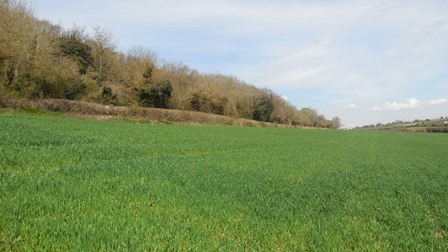
Grange Lane is one of Hartley's few true remaining country lanes.  Starting from Hartley Court Cottage near the Church, it descends part way down the valley side between Foxborough Wood and Haley Shaw, before taking a sharp left turn to follow the edge of Foxborough Wood.  The section by the wood has some of the finest views of the Hartley Bottom Valley.  The road then takes a sharp right to go down to the valley floor and then up the opposite side to meet Hartley Bottom Road at Red Cow Farm.

Hartley Kent: Grange Lane
Grange Lane - Section by Foxborough Wood

Grange Lane itself is a misnomer, caused by a misreading of the map.  It is presumed the name they intended was Orange Lane after the name of the hill at the Red Cow Farm end of the road.  I have not been able to find any early reference to the road being called this.  Earlier references to the road have variously called it Red Cow Lane (1906), Red Cow Hill (1931, 1935), Foxborough Lane (1935) and Grange Hill (1939).  It is not certain why the council settled on Grange Lane.

In 1929 the owner of Hillside House complained about the state of the road, Dartford Rural District Council said traffic on the road was too light to do anything about it then but they did conduct repairs in 1931.  In 1935 the road was tarmaced for the first time.  Kent County Council restricted heavy goods vehicles using Grange Lane in 1931 (following plans in 1929) but rescinded the order in 1965.  However a weight limit of 7.5 tonnes was brought in by the council in 1996.

Grange Lane has only three properties built along it, the c19th Hartley Court Cottages and two built on Small Owners plots - Hillside House and Hartley Dell.  Most of the land that borders the road is farmland or woodland.

Hartley Kent: Grange Lane
Grange Lane: (1) Church Road entrance; (2) By Foxborough Wood; (3) As it descends to the bottom of the valley.


Statistics about the road


SubjectNotes
Length of Road
0.60 miles (959m)
ClassificationU12965 Unclassified single carriageway (adopted)
Area75.81 acres (30.68 ha)
Houses2 detached houses
1 detached bungalow
Housing Density0 houses per acre (0.1 houses / ha)
Population (2011)7
Information about the houses
Explanation:
 
1. Date of Construction is sometimes approximate.
 
2.  Plot  histories include the ancient farms and fields with the  earliest    known  date, also the  name of the smallholding sold by  Smallowners    Limited at the beginning of  the 20th century.
 
3. Planning Permissions include the reference number, so more details can be seen at Sevenoaks Council.  
 
4.  Before Council Tax the tax on residential property was called  the     rates.  The registers for 1956, 1963 and 1972 are  held at Sevenoaks     Council.  The rateable value given is the gross  estimated rental   value   of the property, that is how much  the Valuation Office thought   people   would pay to rent it for a year, the  rates were actually   calculated  on a  lower value after certain  statutory allowances were   made.  For  some  reason the 1956 register  contains the rateable value   for the  properties  as it would  have been in 1939.
 
5.  Council  tax is based on what the Valuation Office thought the    property  would  have sold for in 1993.  It is divided into 8 value   bands.
 
6. House price data 1995 to date produced by Land   Registry  © Crown copyright and database right   2019. This data is   licensed under the Open Government Licence v3.0.  To report  an error,   go to Change a sales record form.

I   have tried to make sure the information is accurate, but no     responsibility can be taken for any errors.  If  you plan to rely on    the  information, you should check the source data to be sure.  If you    spot  an error, please let me know  via the contact form.

Hartley Court Cottage, Grange Lane DA3 8DY (1858)
Detached House
1392 Plot mentioned as being part of Hartley Court Estate
1858 First Built
1925 Planning Application: (GRANTED) 1925/Meeting 1925-08-04 Extension of stairs
1938 Planning Application: (GRANTED) 1938/2873 Addition to building
1956 Gross Rateable Value: £44
1963 Gross Rateable Value: £106
1970 Planning Application: (GRANTED) 1970/503 2 storey rear extension
1972 Gross Rateable Value: £395
1976 Planning Application: (GRANTED) 1976/676 Replacement Detached Domestic Double Garage And Utility Room
1993 Council Tax Banding: G (£160-320K)

Hartley Kent: Hartley Court Cottage, Grange Lane
Hartley Court Cottage, Grange Lane

Hillside House, Grange Lane DA3 8LH (1921)
Detached house
1392 Plot mentioned as being Part of a 30 acre field called "Eyleye", part of Hartley Court Estate
1921 First Built
1922 Advertised Price: £1150 (31 Aug 1922)
1956 Change of name from Irene House to Hillside House
1956 Gross Rateable Value: £35
1963 Gross Rateable Value: £90
1972 Gross Rateable Value: £217
1974 Planning Application: (GRANTED) 1974/404 Erection Of A Kitchen And Study Extension At Front Of Dwelling
1976 Planning Application: (GRANTED) 1976/993 Double Domestic Garage At Front Of Dwelling
1982 Planning Application: (GRANTED) 1982/955 Two Storey Extension To Dwelling
1993 Council Tax Banding: G (£160-320K)

Hartley Kent: Hillside House, Grange Lane from Hartley Hill
Hillside House, Grange Lane from Hartley Hill

The Dell, Grange Lane DA3 8LH (1933)
Detached bungalow
1844 Plot mentioned as being Part of a 17 acre field called "The Valley", part of the Hartley Court Estate
1933 First Built
1933 Planning Application: (GRANTED) 1933/Meeting 1933-08-01 Brick Bungalow (Hartley Hill)
1956 Gross Rateable Value: £28
1963 Gross Rateable Value: £72
1972 Gross Rateable Value: £432
1973 Planning Application: (GRANTED) 1973/Meeting Jul 73 Construct bedrooms in roof space
1993 Council Tax Banding: G (£160-320K)

© Content P Mayer 2000-2018.  Created with WebSite X5
Back to content